Nordenskioeld and Marinus
The only transmitted scientific work of ancient cartography is the "Geographia" of Ptolemy. But it can not be the "culmination of cartography" of classical times. The accuracy of its data is much too poor. The average best latitude errors of the Mediterranean is only +-1° and the east west extension of the Mediterranean has an error of 18° or 40 %.[1]
Such a longitude error would be a good result for medieval nautical dead reckoning navigation. But classical triangulation and astronomical positioning was at least 10 times better.[2]
So the data itself is just another argument that the bulk of the Geographia is a medieval product. That was already suggested by Grosjean[3] and by the famous cartography historians Bagrow and Skelton.[4]
How the crude Geographia could evolve from much better data is part of "The Ptolemy Problem". It could be a religious motivated early medieval fake to deceive the coming generations about the true size of the world and the scientific achievements of classical culture.[5] From that perspective one has to read the Geographia with suspicion.
Nordenskioeld began his large final 1896 book "Periplus" with a review of classical times. He found the transmitted literature we have from Greeks and Romans has only one single mention of sea charts. Nordenskioeld:
-
- "PTOLEMY, in the introduction to his "Geography", gives of a chart (from Tyre or drawn by the Tyrian Marinus), of which several revisions were published, and which, to judge from Ptolemy's description, must have been of essentially the same stamp as those mediaeval charts known under the name of portolanos."
As the leading expert on portolans, this opinion of Nordenskiold has considerable weight. He shared it already 1889 in the "Facsimile-atlas". Here he opposed the assertion by Theobald Fischer that the Greeks and Romans probably never employed nautical charts for practical use (p. 48):
-
- "The description and criticism of the works of Marinus of Tyre by Ptolemy shows on the contrary that the [pinax] of Marinus was a real portolano, provided with a text, which seems to have had much in common with the "Opera chiamata Portolano" of the middle ages, and of which, as of the portolanos, several editions had been issued."
He even saw evidence for a common occurrence of these classical portolans:
-
- "If Ptolemy himself had not always spoken of Marinus as a definite personality, it could even be conjectured that the name (greek), or the Tyrian sea-fish, had only been a collective name for a certain category of nautical maps, like the name Waghenaer, or Waggoner, fourteen hundred years later. The numerous editions mentioned by Ptolemy indicate that the Tyrian charts were made for a practical purpose, and the improvements, introduced according to Ptolemy in every new edition, constituted the germ for the future master-piece."
He concludes: "... it seems to me highly probable that the first origin of the portolanos is to be derived from the Tyrian charts described by Ptolemy under the name of Marinus."
Nordenskioeld further on Marinus work:
-
- "Unfortunately we have nothing left of the geographical work of Marinus, the last "edition" of which by Ptolemy is called (greek) "an improved edition of the geographical plate". But the criticism of it given by Ptolemy in chapters VI-XX of his Geography and described in detail in my Facsimile-atlas, shows that it formed a map, with accompanying explanation, of the known part of the world, based on itineraries and descriptions of voyages, and written specially for navigators. The coast-countries were the most completely mapped and described.
-
- The maps, or the map, were accompanied by geographical tables, probably indicating latitude and distances of various places from one another, sailing-directions, etc. The work appeared in several gradually improved editions, of which the last one was not accompanied by maps." (1896), p. 10
Â
Â
The Pinax and the Dragon Tail
Nordenskioeld called the map of Marinus a "plate". Indeed the original word "pinax" means a painted board of wood or other hard material. The Latin word would be "tabula" and was used for the oldest portolan atlas by Vesconte of 1313. Vesconte wrote there that he made "istas tabulas". Each vellum chart was clued onto two panels that could be folded together to keep the map safely inside.[6]
The map of Marinus was only a singular pinax, a single board and not a collection of boards like Vescontes tabulas. This pinax was sold together with a book, probably a codex. But in the last edition Ptolemy mentioned the book was without the pinax. So we have the odd situation that the book could exist without this map but the map was never mentioned without the book.
That does not fit a portolan map. But it fits well what the portolan transmission map may be: An overview world map covered with a 5 x 5 gon grid. The book would then have some of the grid sections in more detail with habor names and coast descriptions. As an overview tool the pinax itself was only a supplement and not much useful without the book.
It would ease transport and storage if the pinax and the codex were of the same size. Even if folded on two or three panels the world map then had no space for much names like a Cantino type portolan planiglobe of the 16th century. Again this fits the search because the portolans exhibit no classical toponyme heritage.
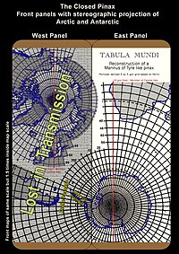
According Ptolemy the Marinus map was based on latitude and longitude and had an equirectangular projection on 36°. So the pinax was a world map with a grid to guide the user for detailed descriptions in the codex. A 4th century world map would have Rome or central Italy at the center. That would place the Bering Strait at the east and west end of the map. On a three panel pinax the map would look like the reconstruction below. The crucial issue is Italy at the center of a three panel map. All other details like the 5 by 5 gon grid are of minor importance.[7]

A reconstruction of a Marinus of Tyre like Pinax according Ptolemy and Nordenskioeld. Three wood panel were covered with a parchment map of the world. The inside an equirectangular projection. At the front panels a stereographic polar projection of Arctic and Antarctic. The Gon grid was added after it was found in the Normal Portolan. And after the Gulf of Kos portolan anomaly pointed to a world map as source for the Normal Portolan. The European part of the pinax suffices as sole root source of the Normal Portolan. With Italy placed at the center of a three panel pinax a lot of other early map mysteries are explainable by partial transmission of the pinax.
The two joints of the pinax will break within one or two centuries. The following transmission of the separated panels offers a unique explanation of some map mysteries.[8]
One of this mysteries the Argentinean cartographer Paul Gallez (1920-2007) published 1980 in his book "The Secret of the Dragon Tail - Knowledge of America before Columbus".[9] In several world maps around 1500 the east of Asia had a shape like a dragon tail.

The world map of "Henricus Martellus Germanus" (Heinrich Hammer), Florence 1490-92. The first map with the Dragon Tail. It is a mixture of Ptolemy, recent Portuguese discoveries and unknown sources.
The first extant were the four world maps by the German Heinrich Hammer ("Henricus Martellus") from 1490-92. He lived and worked in Florence from 1480 to 1496. Three were small without a grid and only one today at Yale (Beinecke Library) was large with grid and coordinates. Unfortunately this Yale Martellus, found in 1960, is in bad condition and not reconstructed yet.

The world map of "Henricus Martellus Germanus" (Heinrich Hammer), Florence 1490-92. A carefully prepared reproduction by Jose de Lacerda. Unlike the photography, here the date 1489 at South Africa is visible.
Gallez[10] got the opinion that a map fragment of south America was attached to Asia. Besides the general shape he found similarities in coastline details, the river systems and the mountains. Other saw this as "fortuitous" and noted that the toponyms there were from Marco Polo.
Gallez had no explanation how such a wrong attachment happened. A partly transmitted pinax offers an explanation. A Roman time world map would be Rome centered at one panel part. The evidence points to a three panel pinax: a half panel left and right of the full center panel.[11]

The Yale world map of "Henricus Martellus Germanus" (Heinrich Hammer), probably from Florence 1490-92. It is the most detailed "Dragon Tail" map by Martellus. It is the only one with a coordinate grid. It was found 1960 in bad condition and is not restored yet. It is now in the Beinecke Library of Yale University. There seems no better image available.
A high medieval geographer who only got the center panel would conclude that South America must be a part of eastern Asia. To connect it would explain the northward shift we see. There is the possibility that the transmission went through a small scale map.[12]
Â
The Genoa Link
A recent critic of Gallez was by Richardson (2003).[13]
He interpreted the Dragon Tail as a remnant of the land mass that encircled the Indian Ocean by Ptolemy. Richardson argued that after Dias rounded the Cape of Good Hope in 1488 this land mass had to be opened. Unfortunately that is a very common misperception. First, Diaz could not prove that one could reach India that way.[14]
The Portuguese were sure they had found the way to India because that idea was already well established. In May 1291 the two ship "Vivaldi" expedition was launched from Genoa to circumnavigate Africa and establish direct trade with India.[15]
Two months before Vivaldi left port a fleet of warships left Genoa for operations against Morocco. They won in August a battle near Ceuta and continued operation there for another year.[16]
This fleet secured the Gibraltar passage of Vivaldi and probably had to establish a resupply station for his return. By this evidence the Vivaldi expedition was not just an effort by two brothers but of whole Genoa. The puzzling question is what could convince the city council of Genoa to such a large operation? The Greek writings of Herodot and Strabo were not known in Italy before the 15th century.[17]

The world map of the atlas attached to Marino Sanudo's "Liber secretorum fidelium Crucis". He send it to the Vatican in 1321 and it is still there as MS. Vat. Lat. 2972 at the Vatican Library. It was probably drawn by Pietro Vesconte in 1320.
That left only some type of map. But a map that showed the distance around Africa too short. It is not conceivable the Genoese would have tried it with knowledge of the true distances. There are traces of such a map. One is the Marino Sanudo map of 1321. It is like a few others drawn by Pietro Vesconte in the 1320s. Of very same general shape is the Brunetto Latini map dated to 1300.[18]
All this maps have the way from Gibraltar or Ceuta to India only 3 times the size of the Mediterranean. The very same error has the Medici world map traditionally dated to 1351.[19] But on the Medici the shape of Africa is much more realistic. Because of that shape either its date was doubted or the map called a mystery (Hennig).
It seems Genoa was the first city that got access to portolans and possibly some type of related world map:
- The first mention of a nautical chart - almost certainly a portolan - was in the Chronicle of Saint Louis for the year 1270 on a Genoese ship in the Mediterranean.[20]
- In 1321 Marino Sanudo of Venice in his "Liber secretorum fidelium crucis" suggested the circumnavigation of Africa to trade with India. He supported his liber with a map that showed a way around Africa to India.[21] The Mediterranean part of this map was clearly a portolan and probably drawn by the famous portolan maker Pietro Vesconte. Vesconte signed the oldest dated portolan (of 1311) with the note that he was from Genoa. It seems Sanudo was Vescontes patron.
- Possibly a few years older (1308Â ?) is the oldest signed portolan. It was by Giovanni da Carignano, parson of the Genoese parish of San Marco, Genoa.[22]
- Pujades about the early portolan makers: "their activity was restricted essentially to three cities: Genoa, Venice and Palma de Majorca."[23]
In all likelihood Venice got it from Genoa by Vesconte who bragged with his heritage. That reduced the portolans origin to only two cities. An opinion already recorded in 1335.[24]
Hennig reported that the possibility to circumnavigate Africa was never doubted after 1300 and around 1350 even a writer like Boccaccio considered it a self evident fact.[25]
We can conclude that the idea to circumnavigate Africa came up by time (around 1300) and location (Genoa) like the first portolans. Further it manifest itself by the first known portolan world maps.
Â
The China Seaway
The Dragon Tail was not in agreement with the knowledge Europe had in 1490. It went too far south, almost as far as Africa. On the Waldseemueller map of 1507 the tails end went to 35° S.[26]
But Marco Polo in his book of 1298 came back from China by sea and did not mention any tail such far south. He left 1292 the port of Zaitun (Quanzhou). The direct seaway from China just touched the equator at the entrance to Malacca Strait 1° N near Singapore. More Europeans used the seaway from China. Another was John of Marignola,[27] a papal legate to the Mongol Khan then ruling China. Like Marco Polo he left China 1346 by Zaitun for India. During his voyage he reported he stayed for some time at a place 6° S, called Saba. The northern tip of Java is 6° S. It seems the Chinese ship this time went through the Sunda Strait.[28]
That means at least by the mid 14th century the seaway to China was known even by two straits near the equator. There is no record for any Dragon Tail claim to the south.

The Fra Mauro map, inverted according to the modern North-South orientation.
The world maps till the mid 15th century showed no tail and were not much different from Vesconte ones of the 1320s. The famous Fra Mauro map of 1458 presented a Vesconte similar shape and was filled with fantasies. Fra Mauro wrote on the map that he was aware of Ptolemy`s Geographia but thought his time had more knowledge than Ptolemy. According the Italian geographer Ramusio (1485-1557)[29] the Fra Mauro map was
- "diligently drawn and copied from a most beautiful and very old nautical map and a world map that had been brought from Cathay by the most honourable Messer Marco Polo and his father."[30]
Maybe the eastern part was really influenced by a Chinese map. But undoubtly it had the authority to be so. That makes the emergence of the Dragon Tail most puzzling. It was against several accepted voyage records and against all map knowledge collected so far.[31]
Nevertheless all the leading cartographers from c. 1490 to 1520 accepted the Dragon Tail.[32]
The only plausible explanation seems that a map supposed of high authority popped up in the leading science circle. Inevitable at least some of the scientist had to know something about the origin of this map to accept it. So we have the very same situation like around Mercator`s acceptance of the Caerte van Oostlant source data in 1541.[33] And again the source origin may be a "Secret Courts" issue.
The Marini Map

The Hieronymus Marini map of Venice, 1512. The first MS world map with "Brasil" in South America. Preserved in the Library of the Ministry for Foreign Relations, Rio de Janeiro. The Jerusalem center and the south up was very uncommon in 1512. Some details point to an enlargement of a small book illustration as source. In a prior transmission stage it was probably centered on the meridian of Rome. The rivers are remarkable accurate.
This odd map by the Venetian Hieronymus Marini of 1512 is famous for the Jerusalem center position. That feature and the style of its presentation is very typical for a high medieval map but an anachronism in 1512.[34]
There is evidence that this map is an enlargement from a book illustration[35] that was rather small - 100 mm or less in size.[36]
Despite its crude coastline it has some surprisingly accurate details.[37]
Notable is the extension of the approximate correct coastline. It goes to the east direct to the Gulf of Siam, 90° east of Rome. Beyond that is fantasy.[38]
Judging on South America the western map end is 90° west of Jerusalem and America is an extension of Asia. So this longitude extension is much like a pinax center panel just shifted by 20° - the distance from Rome to Jerusalem - to the east. The west was cut by 20° and the east got added a fictitious 20° Asia. The book illustration Marini used was probably created in the 800 to 1300 time frame.[39]
The Portuguese Map Reports
Galvao and Sousa Tavares
AntĂłnio GalvĂŁo (c. 1502-1557), known in English as Antonio Galvano, was from a family in government service. His father was chief diplomat and chronicler of the king of Portugal and he was governor of the fort of Ternate until 1540. After his death he left two manuscripts. One was partly lost[40] but the other got in such high regard that it was published in English by Richard Hakluyt as "The Discoveries of the World from Their First Original Unto the Year of Our Lord 1555", London (1601).[41]
From the Hakluyt edition, London 1601, p. 23f:
- "In the yeere 1428 it is written that Don Peter, the king of Portugals eldest sonne, was a great traveller. He went into England, France, Almaine [Germany], and from thence into the Holy Land, and to other places; and came home by Italy, taking Rome and Venice in his way: from whence he brought a map of the world, which had all the parts of the world and earth described.
- The Streight of Magelan was called in it The Dragons taile : The Cape of Bona Speranca [Cape of Good Hope], The forefront of Africa, and so foorth of other places: by which map Don Henry the kings third sonne was much helped and furthered in his discoueries.
- It was tolde me by Francis de Sosa Tavares [Francisco de Sousa Tavares], that in the yeere 1528, Don Fernando, the kings sonne and heire, did show him a map, which was found in the studie of Alcobaza [a renowned Cistercian monastery used as a library by Portuguese kings], which had beene made 120 yeeres before, which map did set foorth all the navigation of the East Indies, with the Cape of Bona Sperança [Cape of Good Hope], according as our later maps have described it. Whereby it appeereth, that in ancient time there was as much or more discouered, then now there is."
The very same Francisco de Sousa Tavares put the book in print at Lisbon 1563.[42]
So the 1428 map from Venice had a seprate South America as "Dragon Tail", because it had the Strait of Magellan there. The Dragon Tail was not attached to Asia yet.[43]
The map further had the cape of Good Hope at Africa. The other map of 1408 showed at least the cape of Good Hope.
Hakluyt printed the following notes beside: "a most rare and excellent map of the world", "A great helpe to Don Henry in his discoucries", "As much discovered in ancient time as now is". There is no doubt that Hakluyt thought this to be a true account and that "ancient time" refers to the Roman Empire.
Â
The Azores
Besides the statement by Galvao there is another source on the 1428 map from Italy. A manuscript by Gaspar Fructuoso (1522-1591) mentioned the same travel of the kings eldest son Don Pedro. He wrote the journey took 9 year - an information Galvao had not - but ended in the same year 1428 Galvao mentioned. The sea chart from Italy motivated Prince Henry ("Henry the Navigator"), the brother of Don Pedro, to send an expedition in the western Atlantic. That manuscript was used by Antonio Cordeyro for his "Historia Insulana", Lissabon 1717.[44]
According Cordeyro, Prince Henry gave an expedition order "to sail straight West, to discover a first island, investigate it and report to him." According the memoirs of Diogo Gomes (c. 1420 - c. 1500), in 1431 Prince Henry ordered "explorations of the far part of the ocean to determine whether beyond the description of Ptolemy some islands or mainland is to find."[45]
That way the Azores islands were found. It is plausible that the same map had South America too. Because the meridian through the western Azores island is close to the most eastern extension of South America.
Â
Magellan
Another mention of this Portuguese maps came from a Spanish source. Ferdinand Magellan, a Portuguese, unsccessful suggested his king an expedition to the west to reach the Mollucas spice island. He changed service and convinced the Spanish king to send a fleet of 5 ships under his command and got granted considerable privileges.
Antonio Pigafetta participated in the voyage and was close to Magellan. In his memoir he wrote that Magellan had prior knowledge of Magellan Strait:
- "But the captain-general said that there was another strait for going out, and said that he knew it well, because he had seen it by a marine chart of the King of Portugal, which map had been made by a great pilot and mariner named Martin of Bohemia."[46]
The Spanish historian Antonio de Herrera gave in 1601 a similar account. According Herrera Magellan told the court of Spain he intended to sail down from the mouth of the Rio de la Plata until he reached the strait. He was very convinced of it because he saw it on a map prepared by the renowned geographer Martin de Bohemia.[47]
Pigafetta wrote further, that Magellan did not know the latitude but was willing to go down to 75° S. He actually found the Strait in 1520 at 52° S. By all known records and notes there was no expedition before him there. Only a globe but no map of Martin Behaim is known. There is no explanation how he got this knowledge.[48]
Magellan thought he could reach the Moluccas Islands (Spice Islands) within one month after he left the strait. Instead it took 11 months and the Pacific crossing took terrible unexpected 15 weeks without any resupply. So it is certain he had no idea of the Pacific size. The map he saw had no Pacific, like it was only a pinax center panel.
Â
Â
The Gomara World Map

The "extremely rare" two part Gomara world map from the 1552 edition of his book "Hispania Victrix". It was banned in 1553 and a search on all copies started. The map is missing from many extant copies. It is the first map with the Aleutian arc.
Of the early printed world maps presented by Shirley (1983) this one with the Americas stood out.[49] It was a two part woodcut in a 1552 book by Francisco Lopez de Gomara. The Americas part began north with the Alaska peninsula and Aleutian arc just about where the Alaska map of the 1597 Wytfliet atlas ended. The whole world map matched well against a square grid projection.[50]
Europe is a crude portolan derivation.[51] But Africa to India shows an incredible good match in longitude - better than in latitude. Direct at the equator is a break where the latitude data gets worse to the south. At five main locations from west Africa to India the longitude error gets down to the woodcut accuracy limit of c. +-1.5°.

Analysis of the 1552 Gomara map with a modern square projection. The grid is in 10° and based on Ferro. The results were unexpected. The fit from West Africa to India is better in longitude than in latitude. The accuracy in Middle and North America is surprisingly good. The Gulf of Mexico is much better than Europe north of Spain. Such longitude data could not be acquired by the navigation we know from the 16th century.
On the American half of the map the longitudes for California, Mexico, Yucatan, Florida and the main Caribbean islands are of similar high accuracy. That is incredible because the Pacific coast of California to the north was not discovered in 1552 and from Pacific to Florida no coast longitudes were measured yet. There is even a good match across the Atlantic to the Canary Islands but the coast of Africa and Spain is careless drawn. Except South America this map half stands out for the accuracy in longitude instead of latitude.
Two results stand out. The hard to measure longitude is often of equal or better accuracy than the rather simple to obtain latitude. Europe north of Spain is much worse than the Florida - Mexico - California coast. The later was just "discovered" in the last 50 years. Such results are only explainable by the involvement of superior map data from outside this time epoch.
In the Americas the equator is 5° to far north. With the here presented match the tropics are about 10 % to close to the equator. Both errors could happen if a 5 by 5 gon grid was found and thought to be a degree grid.
According the Catholic Encyclopedia of 1909 Gomara (1510 - c. 1557) was a priest and since 1540 the "private and domestic chaplain" of Hernando Cortes, the conqueror of Mexico. His book "Hispania Victrix" was about the discovery and conquest of Latin America (and the voyage of Magellan) dedicated to the King of Spain. It was an account based on talks with Cortes and two other named soldiers. But:
- "GĂłmara fell into serious errors and in many instances sinned gravely against historical truth. It was perhaps for this reason that Prince Philip (afterwards Philip II), in a decree issued at Valladolid, 17 November, 1553, ordered all the copies of his work that could be found to be gathered in and imposed a penalty of 200,000 maravedis on anyone who should reprint it. This prohibition was removed in 1727 through the efforts of Don Andreas Gonzalez Martial who included GĂłmara's work in his collection of early historians of the New World..."
So not much copies of Gomara's first editions are extant. But surprisingly: "The woodcut world map accompanying Gomara's work is extremely rare and is missing from many copies." (Shirley).[52]
In some extant copies the very same woodblock is cut by 10 mm in height and in width. Shirley does not report what is missing.[53]
The Arctic
Greenland

The famous and controversial 1558 Zeno map. Claimed to be based on a map left by two ancestors 1380 in Venice. It was in 1569 superseded by Mercator.
The Zeno book of 1558[54] with its map is the most controversial pre 1900 report of arctic exploration. According the author the map and the voyage description were from a manuscript left by his ancestor Antonio Zeno 1405 in Venice.[55]
The story is probably a fake[56] but the map was a first step to a sudden fair presentation of Greenland.[57] On most maps soon after 1558 Greenland was presented much like on the Zeno map but as an island.[58]

Greenland on the Gerardus Mercator world map of 1569. The main part is based on Zeno 1558 like evident by the "Cenobium" settlement. How he got the northern coast as an island is a mystery. Later maps deteriorated the shape until the 18th century.
The first depiction as island could be on the Oronce Fine world map of 1531 that got famous for its Antarctica. The famous Gerardus Mercator (1512 - 1594) had it as island in his 1569 world map but not in the 1538 or 1541 one. Greenland as an island was against all knowledge available then.[59]

The famous and extraordinary 1531 world map by the French scientist Oronce Fine. It is the first Greenland as an island and the most detailed Antarctica.
Before 1000 the only next historic time for a possible warmer summer to circumnavigate Greenland was during the early Roman Empire. Another option would be a sledge expedition like Robert Peary did in 1900. Only then Greenland was confirmed as an island. In 1865 there was still a theory Greenland was connected to Eurasia like always thought before Fine 1531.[60] The Mercator map of 1569 was the best presentation of Greenland until the 18th century.[61]
Hudson Bay

World map of 1544 by the German scientist Sebastian Muenster. Alaska and Canada have similarities with the Wytfliet atlas of 1597.
It was named after Henry Hudson, who explored the bay in 1610. But it was depicted on a lot of 16th century maps and therefore the "Historical Atlas of Canada" concluded it "may possibly have been known to European explorers before".[62] It goes back at least to the Muenster world map of 1544. Surprisingly the elliptical shape is well present, specially in the Wytfliet atlas of 1597. Such a shape is unlikely to recognize without astronomical navigation.
Alaska

Left a map of Alaska over a century before the official discovery. From the Wytfliet atlas of 1597. Right the same area on a modern map.
The known discovery of Alaska began with Vitus Bering in 1741. But with the Muenster world map of 1544 and best by the Wytfliet atlas of 1597 we have a depiction of Alaska 200 years before. The Bering Strait with the eastern capes are present but not the western shore. For such a rather small strait that unusual lacking may indicate that the cartographer only had a map that ended here.
In the north it has the large mouth of the Mackenzie river - first reached by Alexander Mackenzie 1789. The Brooks Mountain chain is called "Bergi Regio" what sounds like German "Bergige Region" - mountainous region. The river below looks like the Yukon.[63]
There is no trace of the Alaska peninsular or the Aleutian arc. The coordinates on the maps are totally wrong, even more in latitude than in longitude. Southward the useful information ends around 60° N where the Gomara map with the Aleutian arc begins.

An atlas of the Americas by Cornelius Wytfliet, printed in Belgium 1597. The maps have no specific projection. The origin of the cartographic data about Alaska and parts of Canada is a mystery.
By the very same wrong coordinates this Wytfliet atlas map is either a partial copy of the Muenster 1544 map or both had a common source. That Wytfliet called his atlas a "Ptolemy" is only a tribute to the coordinate system attributed to Ptolemy. The maps are all of different very arbitrary projections.
The link to Sebastian MĂĽnster (1489-1552) is very interesting. The first work of Muenster was in 1525 the reedition of the Etzlaub 1500 Romweg map. This Romweg map was the first evidence for portolan quality data about the German coast what culminated 1543 in the "Caerte van Oostlant". The compilation error the Caerte had west of Danzig is much exaggerated at the 1544 Muenster map. For a 1544 map the northern and eastern Baltic is rather well.
Antarctica

The first depiction of Antarctica on a c. 1508 world map of the Florence artist Francesco Rosselli. The cartographic data was probably by Henricus Martellus Germanus.
An ancient legend of a southern continent before 1500 is often claimed but hard to find. In the world of Ptolemy was no space left for a continent south of Africa.[64] But after 1500 suddenly maps of Antarctica came up. The first seems to be the world map of Francesco Rosselli c. 1508. The most famous the 1531 map of Oronce Fine (1494-1555) and soon later Mercator in 1538. Most of this maps show a rather similar shape for Antarctica just different in size and exact location.
The Missing Drake Passage
In a few early maps Antarctica has the correct size[65] but even then neither the Antarctic peninsula nor the Drake passage is present.[66]
The Pinax offers an explanation for the missing of the Drake passage and the Antarctic peninsula. The Fine Antarctic had to be from a polar projection. The only place for such a map was on the front side of the closed pinax. Once the west panel got detached from the rest it was no longer possible to find a fit for the Drake passage. Because South America was not on the inside of the panel. That favored a loss in transmission.
Antarctica was probably transmitted by a special polar projection.[67]
That way the North West Passage was probably presented too.[68]
But we have (yet) no evidence that such a north polar projection was transmitted. It got lost like the Drake Passage. That points to the two wing panels of the pinax. Closed they had the space for the north and south polar projections in some unique opportunity.[69]
That arrangement would make the Drake passage the part of the whole pinax that most likely gets lost in transmission.[70]
A Hapgood Explanation

The Hapgood transformation of Antarctica by Oronce Fine 1531 and a modern map overlay
The most detailed analysis of Fine's Antarctica so far was by Hapgood (1966).[71] He identified similarities with a modern map and corrected the Fine map accordingly. He shifted the South Pole in the Fine projection, changed scale and rotated Antarctica c. 20° eastward. He presented the result in several drawings. It is still the only cartographic interpretation yet and a supportive overlay of his result was first published by Hertel (1984).[72] The enclosed graphic is such an overlay mainly based on Hapgood.
The transformation of Hapgood was empirical a matter of best fit only. He supposed Fine did some errors but could not explain why. That is now possible.
The Scale Error: Hapgood was not aware of the Rosseli map that had Antarctica in the right size. By Fine it had about twice that size. Such an error could happen if a 5° grid got misinterpreted as a 10° grid. The portolan transmission map had a 5 gon grid. So it seems the source map of Fine had the same. Hapgood noted that the Antarctic circle (23.5° off the Pole) in the Fine map is only 10° off the new transformed Pole. Assuming a gon grid that changes the reduction from 0.5 to 0.45 and the 23.5° (by 23.5° * 0.45) to 10.6° - what fits well the 10° Hapgood found. So the scale error Hapgood found points to a 5 by 5 gon grid on the source for the Fine Antarctica map.
The Pole Shift Error: By the grid mismatch and the Pole shift Fine solved several cartographic problems of his time. He now got the southern part of Magellan Strait to be part of Antarctica - a view already Magellan had. In east Asia he got Antarctica up to northern Australia and satisfied the rumors about the later Australian continent there. With his Antarctica there was no longer any need for a 7th continent then - for today Australia. The Pole shift further caused the extension of west Antarctica to 25° S what covered the northern New Guinea coast in the longitude system of Fine.[73]
The Ice-Shelves
Hapgood`s suggestion for a late glaciation age date of the Fine Antarctica is discussed elsewhere. But according a 2004 review by Ingolfsson,[74] there is no evidence that the Ross or Filchner-Ronne ice shelves in the last 10000 years were ever that much reduced like on the map.[75]

The Hapgood transformation of Antarctica by Oronce Fine 1531 and a modern map. Further the extension of the last glaciation maximum and the tracks of some of the most famous South Pole expeditions.
At the approximate location of the Filchner-Ronne ice shelf the map shows a narrow deep break towards the true South Pole. It is not possible that the ice shelf - a glacier like flow structure - ever had such a break. It is much more likely that the map here presents the inward and outward tracks of an expedition that tried to reach the South Pole over the ice shelf. For everyone who reached the ice shelf by sea it is obviously a structure floating on the sea. It could be mapped as sea like with dots or shading that was lost in transmission.
That interpretation is supported by the presentation of the Ross ice shelf. The western part is depicted as free water until the southern end at the Maud mountain chain. The same way over the ice shelf took Amundsen in 1911 to reach the pole.[76] There is the possibility that this map shows the track record of an European expedition that reached the South Pole about 1600 years before.[77]
A Roman Marine Chronometer
There is a long speculation how the portolans were surveyed. Besides the impossible dead reckoning a land based triangulation was suggested. Alternative supplemented by Luna eclipses or occulations. But mapping in the Arctic could only be done in the summer. That works only with a marine chronometer. The marine chronometer was a major engineering achievement of the 18th century and it seems at first glance hard to assume a first in classical times.
We have no transmitted texts of mechanical clocks then. The Antikythera mechanism is no clock but the only find close to it. According Derek de Solla Price, who did the first close investigation, for the first archaeologist who saw it "it must have resembled a well made 18th-century clock."
"The mechanism is like a great astronomical clock without an escapement, or like a modern analogue computer which uses mechanical parts to save tedious calculation. ... It is certainly very similar to the great astronomical cathedral clocks that were built all over Europe during the Renaissance."[78]
This mechanical clocks came up around 1300. Neither time, nor place nor name of the inventor is known. According the famous clock historian Rupert Gould, the first portable clock, the "Nuremberg egg" of c. 1510 had "all the principles of the modern chronometer ... the difference between it and the modern machine is purely one of detail".[79]
The invention is attributed to Peter Henlein (1480-1542) because he build the first known one. The use of it as marine chronometer was first suggested by Gemma Frisius, the teacher of Mercator, in 1530.[80]
The high reward offered for a useful marine chronometer by the British Government in 1714 had initially not much impact. Like Gould explained, crucial was the willingness of the advising scientists to finance the development. To support the work of John Harrison (1693-1776) the Board of Longitude from 1728 to 1761 spend 3700 pound.[81]
The result was the H4 marine chronometer with an accuracy of 0.1 seconds per day. For the accuracy of the Pizigani chart a clock had to achieve 4 seconds per day,[82] for the Gomara map 1 seconds per day.[83]
The Antikythera device was build around 100 BC - 400 years before the suspected portolan mapping. So the Roman Empire had up to 400 years for development to get a clock with at least 10Â % of the accuracy the British Empire got by Harrison within 30 years.
Germany and the Secret Courts
In the Arctic part of the Wytfliet atlas of 1597 several place names are found that make sense but sound German. There is at least on example on the Fine map too.[84] It could be that the German names were recognized and removed by Germans (Schoener, Muenster, Mercator) but left untouched by none Germans like Fine or Wytfliet. Anyway it is a possible indicator for a transmission stage that went through Germany. Such a stage was found probable for the Caerte van Oostlant too.
For a low maritime and late renaissance country we had in the above chapters an unusual role of Germans:
- Martin Behaim (1459 Nuremberg - 1507 Lisbon) had a map in Portugal that was crucial for Magellan
- Heinrich Hammer ("Henricus Martellus Germanus") had first Dragon Tail maps and first Antarctica[85] and had a link to Behaim at Nuremberg[86]
- Johann Schoener (1477-1547 Nuremberg) made the first globe 1515 with Antarctica and a pre discovery Magellan Strait.
It is hard to understand that - with only one exception[87] - no book from 1200 to 1601[88] reported or suggested a map transmission from classical times besides Ptolemy. Instead in the first half of the 16th century in Germany - the time and place where the bulk of the new maps came up - two legends were spread that pointed straight away from it.
One legend was that sea charts originate by sailing directions and therefore dead reckoning navigation.[89]
The other legend was about a recent discovery of a southern land called Brasill. Described in a "confused and confusing" (Richardson)[90] German leaflet "Newe Zeytung auss Presillg Landt" (Newspaper about the Land of Brasill) of around 1508.[91]
It was the first information about Antarctica and came up around the same time Rosselli put it first on a map. Both about one year after the death of Behaim. It seems established that a link existed between the leaflet and a 1513 text by Johann Schoener accompanying his 1515 globe. That globe showed an Antarctic continent (in odd shape) and the Magellan Strait later found in 1520.
By this two legends the scientists were saved from prosecution by the Secret Courts. This was a medieval organization with the task to kill anyone suspected of magic, heretics or the transmission of unwanted classical books. The accused were never confronted with the accusations but always tried in absence. Found guilty by the members of the local Secret Court the only possible sentence was death by hanging. It was carried out in secrecy.[92]
According the records the Secret Courts system was active in Germany from c. 800 till at least 1490. It was controlled by local Bishops and had 144 local chapters in Germany 1490.[93]
Outside Germany they were probably active since the large campaign of magic books burning around 375 in the now Christian Roman Empire.[94]
In effect this organization could prosecute any pagan or even scientific culture. The area of influence spread with the rule of medieval Christianity. The last area that got under control that way was Germany and Scandinavia. Prussia - then east Germany - became Christian by bloody conquest in the 13th century. Refuges went to the neighboring state of Lithuania that became Christian in 1386. There any suspicious book had to hide only 100 years whereas in Italy it was for 1000 years. So any transmission in the north was much more likely than in Italy.
- Forstner, Gustav: Längenfehler und Ausgangsmeridiane in alten Landkarten und Positionstabellen. Dissertation, Universität der Bundeswehr, München (2005), p. 66
- Europe in the Hakluyt-Wright world map of 1599 had an average longitude error of +-0.9°. Forstner (2005), p. 168. The "Catalogus Locorum" part of Johannes Kepler`s 1627 "Tabulae Rudolphinae" has for 34 western Europe main cities (Lisbon to Vienna) an average longitude error of c. +-0.6° and latitude c. +-0.4°; Forstner (2005), p. 122. The technique used (probably lunar eclipse or occultation observations) was well within the capabilities of the Roman Empire. The portolans had a longitude and latitude error of c. +-0.4°.
- Grosjean, Georges: Geschichte der Kartographie, Bern 1996
- Bagrow, Leo; Skelton, Raleigh Ashlin; Paisey, D. L.: History of Cartography, 1964
- It was probably prepared like the Almagest by Theon of Alexandria around 370-390 under the order of church authorities. By them it was first used too. According Nordenskioeld Ptolemy's work was the sole source of information in the description of the world in chapter 2 of the famous Christian writer Paulus Orosius: De Miseria Mundi (History Against the Pagans) of c. 417.
- Pujades (2007), p. 441
- The 5 by 5 gon grid will explain the transformation of the Fine 1531 Antarctica and some latitude error in Gomara 1553. It only gets crucial in explaining the compilation errors of the Normal Portolano in the 13th century. Only there the 5 by 5 gon grid was found.
- List of possibilities (with evidence found):
- West panel inside drawings: Partial transmitted to 1500 (Muenster 1544, Gomara 1552, Wytfliet 1597)
- Center panel inside drawings: Partial transmitted to 1500 (Martellus 1490, Marini 1512, Gomara 1553)
- East panel inside drawings: Not transmitted to 1500 (?)
- West panel front drawings: Not transmitted to 1500
- East panel front drawings: Partial transmitted to 1500 (Rosselli 1508, Leonardo da Vinci 1514, Fine 1531)
- It was in French and German but has no English edition yet; Gallez, Paul: "Das Geheimnis des Drachenschwanzes - die Kenntnis Amerikas vor Kolumbus" Berlin 1980. Latest was a Spanish edition: "La cola del dragon", 1990
- The idea did not originate by Gallez. Before him were Enrique de Gandia in 1942 and with Gallez was Edgar Ibarra Grasso.
- There is evidence to favor such a three panel over a two panel version. It is the Alaska map of the 1597 Wytfliet atlas. It ended along the Bering Strait. Every cartographer would have included the Asian side of the strait. So it was probably lost in transmission. That could only happen in a three panel version but not a two panel one. Only the misplaced South America of Gallez would happen with a two panel version too.
- The shape of the southern tip may be an abstraction a small map may create. A map size then would be like an upper part of a codex page or drawn in wide line. That would explain the lost Caribbean island. It could be linked with the Marini map (see below). Against a small map stage argues the iddentification of small coast and lake details by Gallez. An examination of the Yale Martellus may solve this issue.
- William A. R. Richardson: South America on Maps before Columbus? Martellus's 'Dragon's Tail' Peninsula. in: Imago mundi: the international journal for the history of cartography. Volume 55, Issue 1 October 2003, pp. 25 - 37
- The most eastern part of southern Africa he reached could still be a gulf at the land that encircles the Indian ocean. Some maps, like that of Giovanni Leardo (1448), showed large gulfs around Africa. According an inscription at the Fra Mauro map of 1458 a Chinese junk in 1420 reached from India the south tip of Africa and went 2000 miles southwest in the Atlantic. Fra Mauro further wrote that from this and Strabo he concluded it was possible to circumnavigate Africa. We know today that the Chinese information was probably true. But neither Fra Mauro nor the Portuguese could know it for sure nor had any prove until they reached India or at least Somalia.
- The ships were commanded by the brothers Guido and Ugolino Vivaldi. A Tedisio Auria or Thedisio Doria is recorded too. They were last seen at Cape Juby (Tarfaya) opposite the Canaries at the Atlantic coast of Morocco. In 1315 Sorleone Vivaldi, son of Ugolino, reached Mogadishu by land in search for his father. The records in German translation were presented by Hennig, Vol. 3, (1953), pp. 119ff
- Hennig, (1953), p. 131
- This is specially true for Strabo, Hennig (1953), p. 127f. Herodot with his 3 year duration claim would not have supported the expedition idea.
- It is in Oxford, Bodleian Library, Douce 319 fol. 8. According the website of the Bodleian Library it was dated to 1300 by C. Lucy Sandler.
- The Medici world map is part of an atlas and has a calendar page that begins with 1351. Recently by paleography Pujades thought it may be a mid 14th century copy of some older map.
- Pujades (2007), p. 418
- Hennig, (1953), p. 127. Note that Sanudo began to write his Liber in 1306, 15 years before he presented it the pope.
- Pujades (2007), p. 486
- Pujades (2007), p. 487
- Pujades: "For example, throughout the entire period this book covers [c. 1300-1450], Majorcan cartography and Genoese cartography were characterized by very close links, since Majorcan masters strongly depended on Genoese models in all their aspects. These tight bonds were perceived from very early on by their contemporaries, and underlie the statement Opicino de Canistris makes in his Descriptio Eclesiasticae Hierarchiae (1334-1335) when he speaks of 'mappa marts navigabilis secundum Januenses et Maioricenses'. It was by no means an arbitrary decision on Canistris's part not to include the Venetians" Pujades (2007), p. 480. The Majorcans were called by portolan historians often "Catalans" and their charts be of Catalan style. Nordenskioeld suspected the portolans origin there. The most original chart in Catalan style was the Pizigani of 1367. It popped up in Venice and there is a direct link between Pizigani and Marino Sanudo. See separate article "Pizigani 1367 Chart".
- He thought the Atlantic to be part of the Indian Ocean. Hennig, (1953), p. 130
- Africa was drawn to 45° S, a then wide spread (probably deliberate) misinformation.
- Hennig (1953), pp. 142ff
- Probably then like today Malacca Strait was known for piracy. That was no issue for Marco Polo whose ship was part of a larger fleet.
- Giovanni Battista Ramusio: Navigationi et Viaggi ("Navigations and Travels"), 3 vols, Venice 1550-59
- Falchetta, Piero: Fra Mauro's World Map, (2006), p. 592
- That makes impossible the explanation of Richardson: "It would seem clear that Martellus's fourth Asian ("Dragon's Tail") peninsula is not South America but a hypothetical development of Ptolemy's southward extension of Asia constructed to accommodate the names of places mentioned by Marco Polo, whose identities and locations were unknown or uncertain." Richardson (2003), p. 34. Richardson could only be right with at least one equatorial strait in the Dragon Tail. But no Dragon Tail map ever had one.
- Besides all maps of Martellus around 1490 to name a few others: Behaim 1492, Laone Globe 1493, Cantino 1502, Caverio 1505, Ruysch 1507, Waldseemueller 1507, Rosselli 1508, Leonardo da Vinci 1514, Schoener 1515, Waldseemueller 1516, Coppo 1520, Apian 1520, Vadianus 1534
- link: Mercator and the Science Community
- The south up is much more typical for high medieval too.
- *The Jerusalem disc is now too large in proportion to the map and buries part of the coast. On a smaller map it just had the necessary size to present the symbol.
- The coastline has an extreme bay exagerration that results from a scale up of every move in the small ink line
- Ireland and Britain are too small and too crude. On a small map that would be less noticeable.
- The local Seas (Adriatic, Aegean, Red, Baltic) are disproportionate in wide. Typical for a small map with a feature size approaching the ink line wide.
- The islands in the Mediterranean are all of same size, only Corsica is smaller. The Baleares are missing. So Corsica was the smallest size to draw, probably a around one ink line wide. It is 90 times the map wide. By a line wide of 0.5 mm the book illustration was only 45 mm wide and 35 mm high.
- The rivers are about correct and the Caspian Sea better than most maps around 1512. The east till the Gulf of Siam is better than most maps of this time too.
- Judged by the geography. The grid lines on the map are like a poor 1512 guess work and can be ignored.
- There was some type of Renaissance in the Latin and Greek regions in the 9th century. Older 5th century material was discovered and used. In the centuries before 800 such an illustration may unlikely be created or to survive in clerical circles. The Jerusalem fixation points to an creation in clerical culture. After 1300 the portolans got spread and the shape of Ireland, Britain and the Baltic would be drawn different. Ireland and Britain would be better then, but Jutland, Scandinavia and the Baltic worse than on this map.
- "History of the Moluccas"
- The original was AntĂłnio GalvĂŁo: "Tratado que compĂ´s o nobre & notauel capitĂŁo Antonio GaluĂŁo, ... de todos os descobrimentos antigos & modernos, que sĂŁo feitos ate a era de mil & quinhentos & cincoenta", Lisbon 1563. http://en.wikipedia.org/wiki/Ant%C3%B3nio_Galv%C3%A3o
- Acc. John Carter Brown Library: "Portuguese Overseas Travels and European Readers".
- At the time of Galvao the Dragon Tail at Asia was as a past feature of his youth. With few exceptions it ended around 1520.
- Hennig (1956), p. 70f
- Hennig (1956), p. 71
- The First Voyage Round the World by Lord Stanley of Alderley - Pigafetta's Account of Magellan's Voyage, London (1874) http://en.wikisource.org/wiki/The_First_Voyage_Round_the_World/Pigafetta's_Account_of_Magellan's_Voyage#cite_ref-69
- Spanish source text and German translation in Hennig (1956), p. 391f
- It is not possible that Magellan took a large river mouth - like the RĂo de la Plata - on a map for a strait. River mouths were always identified by the sweat water miles off shore. Any river would be marked as river on a map therefore. Like Pigafetta wrote, Magellan noted the strait entrance by the salty water still inland.
- Shirley, Rodney W.: The Mapping of the World, Early Printed World Maps 1472-1700, London (1983); p. 107, Plate 80 (Entry 94)
- That is an equirectangular projection for latitude 0° based on the equator. It is the most simple type of projection.
- The northwest of the Black Sea is very unique and could be a tracer to related maps. It could be the representation of the Baltic - Black Sea river link.
- "The British Library has copies of editions of Gomara's work dating from 1552, 1553, and 1554 (two locations) but all of these want the world map." Shirley (1983), p. 107
- "The librarian of the John Carter Brown Library has advised me that they have two copies of Gomara's work and that the maps in each are different in size, although apparently from the same blocks. The smaller example measures just over 180 x 280 mm, the difference in size being due to alterations to the block, not to trimming of the printed map." Shirley (1983), p. 106
- Nicolo Zeno: Dei commentarii del Viaggio, Venice 1558. (This Nicolo lived in the 16th century.) English translation: R. H. Major: The voyages of the Venetian brothers Nicolo and Antonio Zeno, in Publications of the Hakluyt Society, vol. 50, London 1873.
- The book tells the story of Nicolo Zeno and his brother Antonio but only Antonio survived and got back to Venice. According the extant Venice records the noble Nicolo Zeno was on a Venetian expedition to Flandria (Netherlands) in 1385 but present again in Venice November 1388. That dates are not in agreement with the story. Hennig (1953), p. 397
- Hennig (1953) reported a lot of voyage details found in books before 1558. He is convinced that it is a fake and makes a good case.
- There is some similarity between Zeno Greenland and a Greenland on a Ptolemy map by Henricus Martellus Germanus of 1480 in Florence. A woodcut with only Greenland of Venice 1528 (the "Isolario" of Benedetto Bordone) is somewhat similar to Zeno Greenland. It even has the fictious north eastern settlements.
- Hennig (1953), p. 400 mentions maps by Ruscelli (1561) and Moletius (1562).
- They know Greenland could not be connected with Norway like on the Zeno map. But the north of Greenland was impossible to reach by land or ship then. There is no record that this was different in the warm period around 1000. In the cold period 1300 to 1900 the north of Greenland was part of the Arctic ice shield. In theory one could then walk around the pole at the 82° circle - south of the Greenland northern coast.
- A 1865 map and other related information is found on a website by Leslie Trager: Mysterious Mapmakers: Exploring the Impossibly Accurate 16th Century Maps of Antarctica and Greenland
- In the later 16th century a British mapping expedition by Frobisher cut off the southern tip of Greenland for a "Strait". That image was already on the posthumous published Mercator map of 1595 and extended well into the 17th century.
- Hayes, Derek: Historical Atlas of Canada, Vancouver 2006
- A geologist pointed out that the arctic rivers create more erosion than others and the transported material creates a faster growing delta. The coastline there may have looked different 1700 years ago.
- A. Stückelberger in: Stückelberger, Alfred and Mittenhuber, Florian (Eds.): Klaudios Ptolemaios Handbuch der Geographie, Ergänzungsband mit einer Edition des Kanons bedeutender Städte; (Supplement with Canon edition), Basel 2009, p. 263. (The land south of the Indian Ocean was part of Africa too.)
- Most notable the Rosselli c. 1508 and the globe gores of Leonardo da Vinci c. 1514 where even the position is correct.
- There is no evidence that the area of the Drake Passage was transmitted to 800 or beyond. Therefore the pinax inside world map had probably no Antarctica. Like in some today maps it was omitted probably for explanation space.
- The Antarctica part of the 1531 Fine map is too good to be derived from an equatorial projection. The Rosselli 1508 map shows the difficulties they had to transform a polar shape in an equatorial one. It is not suggested that a real panel from the 4th century reached the 1500s but just copies. The lack or the misunderstood grid may be a problem for the scientists then.
- The Hudson Bay and the Mackenzie River mouth makes it very likely that they found that passage. In the Roman warm period it was better to find and navigate than in the 19th century.
- If both had the same scale and were turned for the meridian of central Italy (Rome), then the front panels would offer:
- The north projection enough space to present the northern end of the Empire (Rhine river and England) to the Bering Strait. So the way of the northwest passage.
- For Antarctica the Drake passage with a part of South America can be presented and the south tip Africa. To present Africa would offer a more familiar point of view than the probably less known South America.
- The front panel maps would more likely got lost or damaged than the protected inside map. But there is another point. The Drake passage and the Antarctic peninsula would be with South America on the west panel. Once the west panel got detached from the center panel and found alone there was no longer a geographic reference where to connect this map part. Because South America was not on the west panel inside it was impossible to deduce from the coastlines what part of the world it was. North America was unknown. One had to understand the polar and rectangular projection to note Alaska on both sides and realize the map position. Therefore in the Middle Age most people would not understand the west panel without the center panel. It was a useless piece and got lost.
- Hapgood, Charles H.: Maps of the ancient sea-kings, Philadelphia 1966
- Hertel, Peter; Hertel, Gisa: Ungelöste Rätsel alter Erdkarten. Köln, 1984
- The first Portuguese sighting of New Guinea was in 1527. But they were on the "Spice Islands" (Moluccas) just west of New Guinea since 1513. So regional knowledge of New Guinea was probably acquired before 1527. Fine placed Java at 160° E of Greenwich (real: 110° E) and the Ross Sea at 180° E (correct). He had western Antarctica at 205° E, 45° east of Java. He overestimated the longitude of Java by a factor 1.45 (160°/110°). The 45° reduced by the same factor becomes 31°. The real New Guinea is indeed at 110+31 = 141° E. Therefore west Antarctica is where Fine in his longitude system had to place New Guinea.
- Ingolfsson, O.: Quaternary glacial and climate history of Antarctica. in: J. Ehlers and P. L. Gibbard, eds., pp. 3-43, Quaternary Glaciations: Extent and Chronology 3: Part III: South America, Asia, Africa, Australia, Antarctica. New York (2004). (online)
- There was a warm period from around 2000 BC to 500 BC at most sites of Antarctica. But warm period is a relative term. In this period the temperature was not higher than in the last 100 years. Further, the ice-core records for the last 10,000 years "indicated only subtle temperature variations" of not more than +-1° C. So it is unlikely that in this warm period the ice shelves extension was much different from its present state. In the slightly colder time after 500 BC the extension may not be much larger because this period was more arid - with less rain there is less glacier grow too. The ice-shelves are glacier extensions and therefore must be affected the same way.
- Shackleton and Scott went over the Ross shelf ice too but at the opposite side.
- Organized by the Roman Empire a major involvement of people and knowledge from Norway seems indispensable. Amundsen was from Norway and used a low tech approach with traditional materials for his Pole run. There are reasons to believe that the Romans had trade and intelligence links to Norway. The reliance on natives with special capabilities had a tradition in Roman army auxiliary unites and in mercenaries. In 1989/90 Fuchs and Messner reached the South Pole without any animal or modern engine support.
- Price, D. de S. (1959). "An Ancient Greek Computer". Scientific American 200 (6): 60-67.
- Gould, Rupert T.: The Marine Chronometer, London (1960), p. 21. By "detail" he meant several additional mechanisms to be developed.
- Gould (1960), p. 19. The Egg had an error of 15 minutes per day and that was standard "for more than a century" after 1530 (p. 20). The H4 during the 156 day sea trial in 1764 had lost 15 seconds (after correction by the temperature table, 54 sec without correction) or 0.096 sec/day (p. 60).
- When Harrison first arrived in London 1728 he got 200 by the Board member Graham for the H1 development.
- 1737 H1 complete and further 500 from the Board for H2
- 1741 H2 complete and further 500 from the Board for H3
- 1746-1761 further 2500 from the Board for H3 and H4
- 1757 H3 complete
- 1759 H4 complete
- 55 km error over 30 days
- 1.5° error over 334 days (Cape Bojador to south tip of India via south Africa like Vasco da Gama)
- An island "VELSYLOLT" (Felsiges Land, Rocky Land) up on the southern part.
- He worked with Francesco Rosselli (1445 - (1508-1513)) in Florence and was probably his geographic source. Rosselli was only the artist. So the first extant Antarctica on Rosselli`s c. 1508 world map probably came from Martellus.
- The famous 1492 Behaim globe at Nuremberg is very close to to the Dragon Tail maps of Martellus of 1490-1492. Either Behaim copied Martellus or both had a common source.
- The book of Galvao by Sousa Tavares 1555
- The opinion of Hakluyt in his 1601 edition of Galvaos book is notable.
- According Lang (1986), p. 54 it was (first ?) mentioned in Germany by Joachim Rheticus in his "Autographon" 1541. It probably not originated by him but from a source he trusted.
- Richardson, William A. R.: Was Australia Charted Before 1606? The Jave La Grande Inscriptions, 2006
- According Erich Egg (1969) the literature suggests an origin in Augsburg around 1508. According the John Carter Brown Library (2011) it could be from "Nuremberg (1514?)". A version in English and the relation with Schöner is described here.
- The main source for the Secret Courts is a book by a German professor of law at TĂĽbingen: Thudichum, Friedrich: Femgericht und Inquisition (GieĂźen 1889) A scanned version was 2010 on the internet but is now not to find. The Swiss historian who gave the first solution of the Ptolemy Problem did a review of it. It is found with further contributions by him as user "Bibhistor" on the "Feme" Talk page of the German Wikipedia from 4. Nov. 2009 to 30. Dez. 2009. The authenticity of the crucial document of 1490 was confirmed by another historian in 1890.
- The numbers of "Stuhlherrn" and "Freigrafen" together at the 1490 Supreme Secret Courts ("Oberfeimgericht") meeting at Arnsberg.
- There is a whole article about this campaign. One chapter is about the first evidence for the Secret Courts system then.


Comentaris publicats
Afegeix-hi un comentari: