The Ptolemy Problem
The whole problem of the origin of portolan charts is centred around one single point, best be called "The Ptolemy Problem". Most researchers were well aware of it but only few dared to put it in clear words. The problem and its possible solutions affect a lot of other topics and could be linked to a question most historians tried to avoid: Was our transmitted classical history sometime subject to some systematic manipulation?
The Definition

A typical portolan, the Ptolemy and a modern map. The 50% Error of the Ptolemy in longitude size is corrected here to allow a comparison.
Because of the accuracy and any lack of development traces the portolans could not originate in the Middle Ages. The classical times, specially the Roman Empire, is then the most probable origin. This time had the need[1] and the technical scientific knowledge. The Romans are known for extensive land surveys of good accuracy.
But we have transmitted from the 2nd century the "Geographia" of Ptolemy. It is a book about the location of cities, rivers, mountains, coastlines and state boundaries of the whole known world. It gives coordinate tables and a guide to draw mathematical derived map projections. It is the only cartographic book transmitted from classical antiquity. Therefore it is considered the highpoint of ancient geography.

Ptolemy-Dulcert comparison by Nordenskioeld in his Facsimile-Atlas 1889
Even a short look on a map drawn by the data of Ptolemy reveals a very poor accuracy compared to portolans. The portolan Mediterranean has an accuracy of 1Â %. The Ptolemy had even the basin length 50Â % too large. The regional error of Ptolemy was up to 100Â %. The accuracy outside the Mediterranean was such abysmal that the coastline formed a unique shape very distinct from portolans or reality.
How could any portolan originate from classical times that had such poor maps? That is the Ptolemy problem. It was first presented by Nordenskioeld 1889 in his Facsimile Atlas. He presented the coastline of the Dulcert (1339) portolan side by side with a Ptolemy coastline map (pp. 30f). But his text about the problem was spread over the whole book. So it was rather Hapgood in his 1966 "Maps of the ancient sea-kings" who was able to put it clear on a few pages. He referred full on Nordenskioeld and even used his two maps to illustrate it. Most other historians never compared portolans with Ptolemy. What hindered somewhat to appreciate the portolans accuracy.
The Solutions
Hapgood suggested the most rigorous solution: The portolans originate from a forgotten civilization soon after the ice age around 8000 BC. He was inspired to this prehistoric time by remains of the white ice shield around Scotland on the Ben Zara portolan map,[2] an ice free Antarctic shore on the Piri Reis map,[3] the lack of deltas but estuaries on Catalan portolans like the Dulcert. The estuaries belonged to a group of geomorphologic coastline changes that really pointed to a high age. It was an argument hard to counter. It was only solved by the context of other coastline errors that resulted from the portolans scale history.[4] In the end there was no argument left for a prehistoric date.
The book of Hapgood presented a lot of very subjective identifications.[5] But he always presented his data by maps or even transformed maps in a way every reader could see his line of thought. Therefore his book is of some scientific value. He may be the first author who connected the portolans with other printed maps, specially those of Greenland and Antarctica.
That "extended portolan problem" is a matter almost completely ignored by historians. The generation of Nordenskioeld and Wagner could not note the accuracy of Greenland or Oronce Fine`s Antarctica because there were no similar accurate modern maps then. The ice covered "Gulf" of the Filchner shelf ice was not known yet. The issue of those old Artic and Antarctic maps and the important relation to portolans will be dealt elsewhere. It does not support a prehistoric date. But Hapgood was the first to gave it sufficient attention.
The book of Hapgood was probably the trigger for a much different solution of the Ptolemy problem. To explain Fine`s Antarctica and the whole portolans some suggested that this maps originate from a gift by extraterrestrial visitors. That solution had more followers in science than the published literature may suggest. It was a most unfortunate blow for the whole research subject.[6] This solution could not be disproved but made unlikely by the find of evidence for other solutions.
Nordenskioeld and Wagner suggested an origin of the portolans around the time of Ptolemy or even before.[7] Both saw a link to Ptolemy[8] but none had any suggestion how portolans could have evolved from the abysmal Ptolemy data or how both could have coexisted.[9]
So neither offered a solution but Bagrow (and Grosjean based on him) had one. He presented evidence that suggested the Geographia of Ptolemy to be mainly a Byzantine creation of the 10th century. But the most ground shaking discovery came from modern astronomy and hit Ptolemys most famous work, the Almagest.
Â
The Almagest Controversy
Of all 20th century books about Ptolemy, one was much standing out. It was 1977 "The Crime of Claudius Ptolemy" by the astronomer Robert R. Newton. It dealt with the "Syntaxis" of Ptolemy, better known by its Arab name "Almagest". It is about the only astronomy book we got transmitted from classical times. Therefore this book and its author Ptolemy are considered the highpoint of ancient astronomy. In the Almagest the Geographia is mentioned as a next book he intended to write.
Newton initially had no interest in Ptolemy or classical astronomy. Instead under contract for the US Navy[10] he investigated ancient astronomical observations to get a long time record of the moon orbit and a check of the ephemerides time.[11]

The fake of Ptolemy. His claimed observations for Sun and planets. The true values and the results of his theory. Data according R. R. Newton (Sun) and Barbara L. Welther (Planets).
Newton checked Babylonian, Assyrian, Persian, Arab and European medieval reports. But those of Ptolemy almost never got in agreement with certain knowledge we have of the planetary orbits.[12] Newton found that Ptolemy had most of his observation data not observed but calculated to fit his theory. Newtons final summary:
"All of his own observations that Ptolemy uses in the Syntaxis are fraudulent, so far as we can test them. Many of the observations that he attributes to other astronomers are also frauds that he has committed. His work is riddled with theoretical errors and with failures of comprehension, ..." Newton (1977), p. 378
The fake of observations was confirmed by several other historians.[13]
So Newtons find is not controversial. But Newton called Ptolemy a fraud, hoaxer and further sums up:
- "His writing of the Syntaxis has caused us to lose much of the genuine work in Greek astronomy... It is clear that no statement made by Ptolemy can be accepted unless it is confirmed by writers who are totally independent of Ptolemy on the matters in question. All research in either history or astronomy that has been based upon the Syntaxis must now be done again.
- I do not know what others may think, but to me there is only one final assessment: The Syntaxis has done more damage to astronomy than any other work ever written, and astronomy would be better off if it had never existed.
- Thus Ptolemy is not the greatest astronomer of antiquity, but he is something still more unusual: He is the most successful fraud in the history of science."
- Newton (1977), p. 378f
Near the end of his investigations Newton found that he was not the first astronomer to note that Ptolemy faked his observations. In 1819 the well known French astronomer J.B.J. Delambre wrote about it too. Unfortunately it was ignored by the historians. This failure caused Newton to waste a lot of time until he rediscovered it. Inevitably Newtons harsh and very plain words about Ptolemy were received by several historians as a critique of their work and the whole branch. Responses ranged from personal attacks to misrepresentations[14] or simple ignorance. Some presented data that further supported Newtons find but wanted to excuse Ptolemy from a human perspective.[15]
Â
The Overlooked Details
In this emotional debate some important details got not the deserved attention. There is general agreement that Ptolemy wrote around AD 150 in or near Alexandria. But there is no record of the Syntaxis or Geographia before the 4th century.[16]
The so called "Handy Tables" of Ptolemy, part of his books, were probably not created by him.[17]
According our transmitted history Ptolemy was the highpoint of classical science. He wrote the main books on astronomy, geography, optics, music (lost) and astrology. Like one historian said: "they represent a culmination as well as a final synthesis of the scientific tradition".[18]
But we have no record, no mentioning of Ptolemy himself before the 4th century. The 3rd century lexicographer Diogenes Laertius in his extensive survey of past great philosophers mentioned Ptolemy or his work with not a single word.
This odd situation gets another strange twist by the quality of his work. The planetary positions calculated according Ptolemys theory were during his live time in error of up to 8° for Mercury, 4° for Venus, 2° for Mars, 1° for Jupiter and Saturn.[19] The Moon longitude up to 1°.[20]
The observation error of a simple astrolabe is around 15 arc minutes (0.25°). The error of Ptolemy with his stationary instrument was 6.6 to 8.8 arc minutes according his star data.[21] Tycho Brahe achieved with his best instrument an observation accuracy of 0.5 arc minutes (0.0083°).[22] This was perhaps the accuracy limit for naked eye observations.
Â
The lack of improvement
So the errors of Ptolemys theory were visible with a simple instrument already during his lifetime. The error was over 100 times beyond the observation limit. It is not possible that no classical scientist after him noted that. The classical world had a lot of interest in astronomy.[23] Astrology was a popular application and people wanted personal calculations with the most accurate theory.[24]
Ptolemy could not predict the most impressive celestial event - the position of the shadow of a solar eclipse. Not even whether the eclipse would be total or partial. He could only predict the time for lunar and solar eclipses much like the Babylonians long before him.
But by careful observation and some calculation the position of the solar eclipse shadow was predictable in advance. So even without a mathematical genius observations would get appreciable results. Another benefit of an observatory would be the longitude measurement for long range voyages.[25]
By the prediction of a star occultation the Roman survey service could join together maps from different regions of the empire. So the need for observations and a better theory seems obvious. Why was Ptolemys work not improved?
Theon of Alexandria, the last known member of the famous library there, got known for his prediction and observation of a solar eclipse in 360. Strangely this very same Theon wrote about Ptolemys work without any improving remarks.
Â
The Observation Hint

Ptolemy with a armillary sphere model. With a large version he claimed his solstice observations. Painting by Joos van Ghent and Pedro Berruguete c. 1476 for Federico da Montefeltro, Duke of Urbino. Today in Louvre, Paris.
The undisputed find of Newton that Ptolemy calculated his "observations" has another still neglected aspect. Ptolemy several times emphasizes that he did his observations himself and described the instruments he used. He did not tell the size of the divisions on their graduated circles but still Newton could estimate the errors of such observations. Surprizingly the observation values Ptolemy gave were exact the calculation values according his theory. Newton described it as the fake of a typical early beginner student.
Elsewhere Newton granted Ptolemy still to be a mediocre astronomer. But someone with even basic astronomical knowledge would know that every observation has some error. To give the exact calculation values as observations makes it visible as fraud - at least for an astronomer. It may not be such visible for modern historians untrained in Greek calculations. But how could such a fraudulent work survive from the 2nd to the 4th century without exposure?
The errors in Ptolemy`s theory were well visible by a simple astrolabe or sometimes even with the naked eye. Any moderate astronomer could find the observations as fraudulent just by a check of the calculations. But the most known astronomer of the 4th century, Theon of Alexandria, dealt with Ptolemys work and gave no mention of this. There seems something odd in the 4th century.
Â
The Crucial 4th Century

The history of science by size of libraries. In early medieval times a collapse over three orders of magnitude happened. Only 0.1Â % or one in thousand book titles got transmitted.
The 4th century saw a total change of the culture in the Roman Empire. At the begin christianity was suppressed. At the end it was the only allowed religion of the state and the temples of all other religions were destroyed. The museums and libraries of the classical world were considered pagan temples and destroyed too. The over hundred millions of books probably in circulation at the begin of the century got lost.[26] Not a single one got transmitted through the Middle Ages. The library of Alexandria in AD 350 may had around 1 million books. The largest known in the early Middle Ages, Cassiodor in c. AD 576, had only around 100.
The main time of book burning was probably the second part of 4th century. According historical records, people burned their own whole libraries in fear of witchcraft accusation. The accusation to be in possession of magical books could cause a terrible death by slow torture over a fire. Books of the classical liberal arts were considered magical books and burned that way.[27]
Unlike the prevailing historical record written by Christians, the archaeological record shows evidence of a very violent and brutal destruction of classical monuments and peoples.[28]
Exact in this most dangerous time lived Theon of Alexandria, main representative of the classical sciences. He got not killed but wrote commentaries about the books of Ptolemy. It seems possible that he was Ptolemy.[29]
That would well explain the fraud Newton found. It may be a deliberate break point set by Theon only another astronomer could find. Someone without experience in practical measurements would not note it. That nobody would note the fake of observation data of older astronomers is granted by this timeline too. Older books were no longer available to check it.[30]
Hypatia of Alexandria, the daughter of Theon, was a very capable mathematician and astronomer. She teached a private class how to build and use an astrolabe and gave public lectures. In 415 she was cruel killed in the street as a witch by people from the bishop of Alexandria. One Christian source direct mentions astrolabes in the witchcraft accusation. The last pagan philosopher Damascius and the Suda said Hypatia was killed because of "her exceptional wisdom, especially in regard to astronomy."[31] That she promoted the main instrument to reveal the Ptolemy fraud and got this fate has to be considered with the above facts in mind.
Â
The Motive

The oldest transmitted Latin books and literary text fragments. Not one single piece from pagan times before the 4th century.
The destruction of the classical literature inevitable lead to the Middle Age with a very different culture. About 0.1Â % of the classical book titles were preserved in copies from Christian scribes.[32] Most of our classical texts probably originate from single versions prepared in the late 4th or 5th century.[33] By selection of books[34] and small changes in the text an altered version of history was produced.[35]
Synesius, a pupil of Hypatia, mentioned around 400 that the possession of "unaltered copies" was a serious crime then. Books now got "subscriptions" by state or church authorities that the content was correct.[36]
In such a cultural context the works of Ptolemy would well fit. The only competitive system to the geocentric of Ptolemy was the heliocentric system. There is strong evidence that a heliocentric system was more wide spread in classical times than previously thought.[37]
In a heliocentric system the planets were possibly inhabited other worlds and the stars could have planets too. Like suggested by the popular writings of Lukrez (60 BC). In the geocentric system of Ptolemy the planets were only small dots much closer to Earth - just walking stars.[38] They were no worlds but something like the stars - illuminated holes in the heavenly sphere of gods realm. The whole diameter of Ptolemys universe - the distance from Earth to the star shell - was 19865 times the earth diameter or 252 Million km.[39] That is less than the diameter of Earths orbit around the Sun.
Such a pocket universe was well to serve the new medieval culture. Besides the hell inside earth and gods realm in the sky there was nothing left to distract inquiring minds.
The same motivation to shrink the universe explains the Geographia too. The American continent and the Pacific ocean were removed. There was nothing left to discover by ship. The south of Africa was connected to Asia to discourage any attempt to circumnavigate Africa like the Phoenicians already did.
The Geographia Controversy

Greek Ptolemy world map in conic projection. Note the Indian Ocean is totally encircled by land. From Codex Vaticanus Urbinas Graecus 82, Constantinople c. 1300. Parchment 575 x 418 mm. First in possession of Palla Strozzi (1372-1462) then with Federico da Montefeltro, Duke of Urbino.
The Geographia came in the 15th century from Constantinople to the west and was soon translated and printed. First rate geographers like Mercator abandoned it in the 1540s. Others kept it in print until 1715.[40]
In 1945, Leo Bagrow, one of the most important historians of cartography published a paper were he suggested an origin of the Geographia in Byzantine times. He suggested that some parts could belong to a 2nd century Ptolemy but the books of the Geographia we have were compiled after 1100 in Byzantium[41] and based on recent knowledge.[42]
Bagrows paper was a response to a 1932 book by the historian Joseph Fischer of the Vatican Jesuit Order.[43] Fischers intention was to prove that the maps that accompanied our oldest Geographia copies originate from Ptolemy. Then most of the geographic data would originate from Ptolemy too. This was already in doubt before Fischer and Bagrow summarized arguments of other historians against the Geographia too.
In 2006 a two volume German language book was published what had about the same opinion as Fischer. Before, in 2000 an English book with a new translation and commentary came out. The authors had no doubt on the existence of Ptolemy. But they asserted that "Our knowledge of the text of the Geography depends, for all practical purposes, on more than fifty Greek manuscripts, none older than the end of the thirteenth century."[44]
All this 50 mss go back to one single manuscript. According some errors in our mss, this single ms was in capitalis letters like used in late antiquity. The same capitalis letters, but in Latin, traced the bulk of our Latin classical books to the late 4th or 5th century. So from the mss transmission history there is no evidence for an origin in the 2nd century.
Â
The Papyrus Evidence
A text is called transmitted if it went from one person or library to another or got copied. Anything else - even palimpsests - are archaeological finds. Most are papyri from Egypt. Such papyri are the only textual way to check our transmitted texts. Because no codex or roll got transmitted from classical times.[45]
This is often explained by the less durability of the papyrus roll compared to a parchment codex. A notion strongly opposed as "myth" by leading papyrologists.[46]
Â
Papyrus Rylands 522
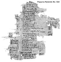
Canon of important cities, 3rd century, Fayum, Egypt.
According Stueckelberger there is no papyri find of the Geographia and therefore it was probably only in low circulation then. But he sees Papyrus Rylands No. 522 of the early 3rd century as undoubtedly the first physical evidence of the Geographia and the first Ptolemy papyri of geographical content.[47]
Papyrus Rylands 522 is a single 113 x 117 mm sheet acquired in 1917 said from Fayum. It contains on one side a list of cities with longitude and latitude. Roberts published this papyrus in 1938[48] and was of the opinion that both papyrus sides were Ptolemaic in origin. But he presented the opinion of Honigmann[49] that such city lists predates Ptolemy. Ptolemy himself stated he used cities latitude data from Hipparchus (c. 194-120)[50]
A latitude list of Hipparchus was used by Strabo (64 BC - c. AD 24) in his geographic work. It showed that Ptolemy even used the errors of Hipparchus.[51] It was already Hipparchus who suggested the locations on earth should be given by degrees of latitude and longitude.
Such tables, even with longitudes, exited before Ptolemy as he mentioned the longitudes of those of Marinos.[52] The table by Ptolemy is known as "Table of Important Cities" or simply "Canon" - derived from its Greek name.
Papyrus Rylands 522 was part of such a Canon. But it is disputed whether it is based on Ptolemy or from an independent tradition that Ptolemy used for his work too.
Ptolemy put a version of his Canon in the Almagest and in book 8 of the Geographia with c. 360 entries. It is like a short version of the c. 8000 place coordinates in the Geographia main table of books 2 to 7. So this 360 cities are two times in the Geographia. But those in book 8 were in a strange unusable coordinate format.[53]
Therefore some suggested that the Canon in book 8 was a later Byzantine addition to the Geographia. Other suggested it to be an early work of Ptolemy or something older than him.
The coordinates in PRyl. 522 differ from those in the Geographia but have similarities.[54] That let Roberts to join the opinion of Fischer that this papyrus is an extended and corrected version of the Geographia Canon.
But a 2000 book by Berggren and Jones about the Geographia did not mention this papyrus at all although Jones was aware of it. Jones mentioned it 1999 several times in his "Astronomical papyri from Oxyrhynchus". According Jones PRyl 522 and 523 belong to a list of nine "wild papyri" that "are open to interpretation as:
- (1) adaptations of Ptolemy's published work by other hands,
- (2) authentic versions by Ptolemy that did not survive into the Middle Ages, or
- (3) compositions independent of Ptolemy, which resemble his tables only because he himself was following established norms."
- Jones (1999), p. 39
Newton in his "The origins of Ptolemy's astronomical tables" of 1985 investigated how Ptolemy calculates the latitude from the longest day in the Almagest. He came to the conclusion:
- "This is a strong indication that the table of the latitude was not calculated by means of Ptolemy's table of chords. Instead, it must have been calculated using a more primitive table that still had many errors of several units in the second sexagesimal position, instead of having no errors of more than 2 units in the third position."[55]
Because Ptolemy used elsewhere a less erroneous trigonometric table this latitude table was probably by Eratosthenes (c. 276 - 195) or someone close to this times.[56] So probably the Canon was not by Ptolemy at all but he just used a table already in circulation. Ptolemy only explained how to calculate it.
Papyrus Rylands 523
The back side of PRylands 522 is known as PRylands 523 and is an astronomical table. Stueckelberger never mentioned its other side despite the fact that Roberts gave a notice to 523 in his first sentence to 522. To give each side an entry is common practice in cases with different content.
The astronomical table is like one in Ptolemys Almagest to describe the zodiac rise over a year.[57]
But according Roberts it used another coordinate systematic than the Almagest table. The Almagest table had an entry for every 10° of the Zodiac, 523 had it for every degree. Thats similar to a table independently published by Ptolemy as a book of its own. But 523 had the arrangement reversed and a different interpolation system.[58] Further 523 lacked the longest day data of Ptolemy.[59]
This lot of differences makes 523 a work of its own. Roberts still suggested 523 could be a copy of Ptolemy under the assumption that our transmitted Ptolemy is not the original one. He called it "a question that can hardly be answered with the evidence at our disposal." Actually he had it even at his desk, but it was indeed hard to find.
It was Robert R. Newton who found it over 40 years later. He analysed the zodiac table in the Almagest. This type of table deals with the transformations of coordinates on the surface of a sphere. It uses spherical trigonometry what needs trigonomic tables to get the results. He found that the trig table used had the same error like those that was used for the Canon table. This trig table was worse than the one Ptolemy used. Newton:
- "To summarize the situation, the tables of oblique ascension were calculated later than the table of the latitude, but in the same general time frame. They were certainly not calculated by Ptolemy. They could have been calculated either by Eratosthenes or by a near-contemporary. They were not calculated using the trigonometric functions of the parameters that Ptolemy gives."[60]
So we have again from Ptolemy clear evidence that there was an astronomical table tradition before and besides him.
Â
Codex PRyl 522/523
Roberts found 522 and 523 were written by the same hand. But the Canon cities table had a more compressed letter size than the zodiac table at the back. The zodiac table was at "Pisces" and it would come to an end after one more column - Pisces being the last of the signs of the zodiac.
The same amount of space would suffice, on 522 at the front side, for the names of the cities in the first column of the table. Roberts speculated that 522/523 was not just from a two sided written roll but part of the page from a papyrus codex. Jones in 1999 was sure that it was a codex page.[61]
Papyrus codices were well known from Egypt. It seems that the Codex had at one page side the cities latitude table and on the other the zodiac latitude table. Given the name of the city, the hour and date of birth an astrologer could get with few calculations the zodiac sign then rising there. So such a codex makes sense.
Â
Conclusion
Both sides of PRyl 522/523 have a content different by names and numbers from the publications we know by Ptolemy. That makes it impossible that this papyrus was ever part of our line of transmission or even close to it. Not just by content but by revealing a codex the papyrus makes strong evidence for a tradition besides Ptolemy. It is an irony that the analysis of Ptolemys transmitted work by Newton was necessary to confirm the clear message of the papyrus. Finally we have no papyrus evidence for the Geographia.
Â
The Agathodaimon Maps

Greek Ptolemy map of Europe c. 1300. In Vatican library.
Some of the oldest extant mss of the Geographia had 26 maps like mentioned by Ptolemy in Book 8.[62] Some of the mss have a note by an engineer (mechanikos) Agathodaimon of Alexandria, announcing that he had drawn on the basis of the eight books the whole inhabited world.
This let Stueckelberger to conclude that Agathodaimon was a member of the library of Alexandria and the maps therefore drawn before 391.[63]
But there is a later link to Alexandria. The Byzantine scholar Maximos Planudes (c. 1255-1305) wrote a poem with the claim that he had discovered the Geographia of Ptolemy, which had disappeared for many years:
- "This work lay hidden for countless years and found no one to bring it to light. But the emperor Andronikos exhorted the bishop of Alexandria, who took great troubles that a certain free-spirited friend of the Byzantines should restore a likeness of the picture worthy of a king."[64]
The mentioned "bishop" was the patriarch of Alexandria, Athanasios II who was in Constantinople at the time, It seems possible that Agathodaimon belonged to the staff of the patriarch in the 13th century.[65]
Jones saw it as probable that Ptolemy draw maps to check the plausibility of his coordinates. But he doubted that the Geographia was accompanied with maps. He mentioned Diller who "has shown that the medieval copies of the text of the Geography descend from a lost manuscript in which there were only about thirty-five lines to a page, which would have been too small for any of the maps."[66] Berggren & Jones concluded:
- "The transmission of Ptolemy's text certainly passed through a stage when the manuscripts were too small to contain the maps... The copies of the maps in later manuscripts and printed editions of the Geography were reproduced from Planudes' reconstructions."[67]
Such a late date of the maps may have allowed to incorporate more recent information of Byzantine origin. The country names on the maps were not from the Geographia text. Some mss had the country boundaries in the coordinate list what probably came from a map to the text.[68]
Kubitschek of the Vienna Academy of Science wrote that the maps show more recent material which Ptolemy could not know.[69] Soon later Schnabel stressed that the map-maker must have been a Christian.[70] and Bagrow suggested that Planudes, who was a cleric, was involved in the maps too.
Even Stueckelberger agreed that after some date the transmission of the maps was independent of the text.[71]
Post Ptolemy Evidence
- In one ms a miniature of the zodiac originates from the year 672[72]
- A cities list dates from August 25th, of the year 534[73]
- Cities and legends in Dacia originate after Ptolemy's time[74]
- Did Ptolemy used a Periplus from around the year 400?[75]
- Used Ptolemy a list from around AD 300?[76]
- A 7th century Armenian "Geographia" had only a version by Pappus of Alexandria as source.[77]
- According this Armenian "Geographia" the version by Pappus of Alexandria
was along the lines of Marcian's Periplus from around 400.[78]
Bagrow saw further knowledge from the 10 - 11th century and concluded "that the Byzantine author of the "Geographia" has presumably used materials of different epochs."[79]
Â
The denied knowledge
So it is certain that the Geographia included post Ptolemy information. This still allows that some part was written by a Ptolemy in the 2nd century. But the main question should not be about the person Ptolemy but about his work. Once proven not the highpoint of classical science the whole perspective changes. Then a fake of the 4th century by Pappus or Theon seems almost certain.
A sentence by Bagrow indicate the earlier times indeed had more focused on the work than the author: Ptolemy "was long considered in the 19th century as a geographer and, to put it mildly, a "charlatan", because he had allegedly failed to make use of the available material."[80]
Bagrow himself failed to recognize the crucial point and goes on to defend "Ptolemy, the great scientist" whose flawless work felt victim to "later Byzantine compilers". It is really deplorable that the 20th century missed the central point of the problem: What are the shortcomings of the Geographia? It denies the reader crucial knowledge already available then. It even works with deliberate deception.
Â
The South of Africa
That`s the case by connecting the south of Africa with Asia. It prevented any attempt to circumvent Africa. But the Greek writer Herodot already explained that Africa is surrounded by sea and was first circumnavigated 594 BC under pharaoh Necho II.[81]
This account by Herodot has high reliability.[82]
The books of Herodot were well spread in Egypt during Ptolemys time, so he had to know it.[83]
No other classical author before Ptolemy connected southern Africa with Asia.[84]Instead several saw the posibility to circumvent Africa.[85] Bagrow found in another classical source, a 1st century Periplus, that the Indian Ocean is connected with the Atlantic.[86] But Bagrow had no suggestion how the Byzantines could be responsible for this "error" of Ptolemy.
Â
The Latitudes of India
A similar credibility problem are the latitudes of India. On the Asia map Stueckelberger was able to identify 10 of 17 cities. All had a latitude error over 4.5°. One "point of departure" had an error of 6°.[87] The southern end of Sri Lanka is 8° too far south.[88] In Roman time there was intense sea traffic to India. Strabo reported 120 ships per year from the Read Sea to India around 24 BC.[89]
Once the ships left the Red Sea or the Horn of Africa they would cross the Indian Ocean along the latitude of their chosen arrival point. They had to know well the latitudes there. If they missed Sri Lanka to the south they would face the open ocean till East Asia. So it is not credible that a geographer at the end of the trade route in Alexandria got such wrong latitudes of India.
Â
The Unused Eclipses
Ptolemy gave Geographia chapter 1.4 the headline: "That it is necessary to give priority to the [astronomical] phenomena over [data] from records of travel."[90] He explains why longitudes derived from lunar eclipses are preferable but complained such data was rare. The only eclipse he reported was of 20th. Sept. 331 BC of 3 hours between Erbil and Tunis. The correct value was 2 hours and 14 minutes. So he introduced an error of 34Â %.
Plinius (Nat.hist. 2,180) reported for the same eclipse a time difference from Erbil to the Greek city Syracuse on Sicily of 2 hours. The correct value was 1 hour and 54 minutes. Syracuse is only 20 minutes from Tunis. Apparently it seems the Greek writer Ptolemy was not aware of this Greek record contradicting his only other record.
But Ptolemy in the Almagest had more eclipse data. In Syn. 4.6 he presented for four lunar eclipses the difference between Babylon and Alexandria. All were in about the same error of only 2° (14 %) too short. The same cities in the Geographia got an error of 6° (41 %) too long.[91] From the Almagest to the Geographia the position difference amounted to 8° (55 %).
So Ptolemy lamented about a lack of data but the same data he already used before in the Almagest. And this data strongly pointed to a much less extension in longitude than what he used in the Geographia. Such an extreme contradiction between both works - in the central issue of the Geographia - is not understandable unless he arranged it deliberately to give a hint that something was very wrong. Like the calculated Almagest observations he gave without error.
Â
The Denied Observation Recipes
The purpose of the Geographia is to enhance the cartographic knowledge. Several times, almost excessive, Ptolemy pointed to a need for astronomical observations[92] to increase the poor accuracy he had. But he gives nowhere, neither in the Almagest nor in the Geographia, any recipe[93] how to do it!
- He does not explain the different stages of a luna eclipse one has to account for.
- He gave no recipe how to measure longitude by lunar distances.[94]
- He gave no recipe how to predict a lunar occultation.
- He gave no recipe how to calculate the parallax at a lunar occultation.
But the Almagest proved that he had the knowledge to do it. And the Geographia had a further prove about its sufficient mathematical skills. He presents the math for several types of projections. The last one is the most interesting. He explained that a globe gives the best presentation because it has no distortions. The only distortion it has is by looking with one eye on it without recognizing a sphere.
Then he develops a projection that preserves this type of distortion on a flat map. This is the most complicated projection and by far the most useless. It is an unprecedented waste of time that only proves the math skills of the author. What first looks like a bragging may be in light of the denied recipes a further hint by the author that he was not free to write what he wanted.
But only a scientist with some experience in this field could not it. Unfortunately science almost vanished in the next centuries. After it came up again around 1400 Ptolemy was uncritical accepted as classical highpoint. Once his errors were known by the 16th century the scientists left Ptolemy to the historians. But the historians had not much classical or medieval work to compare Ptolemy with. They had no other way than to treat him as a piece of its own. By the lack of any better book they had to conclude it as the classical highpoint. After the fraud accusations came up they felt the moral duty to defend the classical world. Indeed their feelings were right, it was no fraud but a hint.
Conclusion
Besides the portolans there is enough evidence that Ptolemy was not the highpoint of classical science. There is no evidence that the Almagest or the Geographia existed before the 4th century. All point to the mid or second half of the 4th century. A careful look does not necessarily support that the author was a fraud, hoaxer or charlatan. Rather he could be a skilled 4th century scientist who gave hints that he was not free to write what he wanted.
Therefore Ptolemy was probably Pappus or Theon of Alexandria. In their time was an extreme cultural break when classical science almost faced extinction. No books from before this time got transmitted. The Almagest and the Geographia were the only books of their scientific branches and written to support the new mindset of the Middle Ages. The scientific level the classical world achieved can not be accessed by this books or other transmitted texts. Rather one should focus on archaeological finds, papyri or medieval / early modern "inventions" not considered in relation with classics yet.
Â
Acknowledgment
The here presented solution of the Ptolemy Problem was first suggested by a Swiss historian. The above text was only possible by his work. He wants to stay anonymous but presented considerable knowledge about the transmission history of classical texts in two German language web pages:
(Transmission History of Classical Literature)
(Transmission History of the Sciences)
Both offered data from hard to find or none English publications. At the last page he appealed for further support.
Â
References
- Besides to support the much larger nautical traffic, Romans had another need for accurate coastline charts. In case of an uprising or invasion it may help to land troops in the rear of enemy forces.
- He only had a b/w photography. It was white restoration paper clued to the back side he saw through holes created by acid ink.
- The map connected South America with Antarctica what limits the credibility of unique accuracy. The islands near Antarctica did not correspond to real islands. That left no much to support his claim. But the Oronce Fine Antarctica was still a point he had. Just it did not support a near ice age date.
- This other errors were the missing U shape bay NW of Crete or the presence of bays that never were. Such features are explainable by the origin of the portolans in a small scale source map. A world map perhaps. This map was then enlarged by a skilled artist and all small dings in the coastline were then exaggerated. That created the "bays that never were". By the lot of such fictive bays there is reason to assume the bay of Ephesus was created the same way. Just by chance at the position the real one was. The missing deltas were just missing like other features too small to be on a world map. The estuaries came up because the big river entries on the world map were drawn by two close parallel lines. By the enlargement the distance between this lines was enlarged too. That way an estuary type river mount was created instead of the delta.
- He often identifies features on modern maps with those on historic maps where other observers may not agree.
- Such visitors are a possibility. A longer time window may raise the probability for such a contact. So this solution can not be ignored. The problem is, that all details could be easily explained that way. And any error and mistake on the maps too. Like they only wanted to give hints to the earthlings. In effect this solution was the scientific based equivalent of the medieval "gods will" mind trap. Then any issue could be explained by the will and hidden intention of god. Our times had outer space visitors to excuse any deep investigation the same way.
- Nordenskioeld once suggested Phoenicians, Wagner the Greeks. Both had their high time before the 2nd century of Ptolemy.
- A similar latitude error of Byzantium and similar errors around Greece (Wagner).
- Some raised the idea that Ptolemy was limited to data from the scientific establishment what ignored the practical maps of the mariners. That was the situation in the Middle Ages according Nordenskioeld and other historians. But Ptolemy explicitly stated that he used data from Marinus of Tyre and other travellers. By the words of Ptolemy Nordenskioeld himself identified the maps of Marinus as portolan like mariner maps.
- The US Naval Observatory then was responsible for the prediction and improvement of the astronomical ephemerides - the positions of the stars, planets, sun and moon. The ephemerides time was based on this and later replaced by atomic clock time. This clocks were more accurate than the unsteady movement of earth.
- His final work on it: Newton, Robert R.: Ancient Planetary Observations and the Validity of Ephemeris Time. (1976)
- Some of the other observations had small disagreements with present theories. But Ptolemy was far out.
- *Gingerich (1980): "These errors can be as much as a degree, and sometimes more. He [R. R. Newton] also finds (and I generally confirm) that the reported positions agree very closely with Ptolemy's theory - generally well within 10 minutes of arc. Somehow, according to Newton, the match with theory appears just too good. In his opinion this means that Ptolemy simply made up these observations."
-
- Gingerich then raised four hypotheses to explain the problem. The first one is almost like the "Ptolemy Problem" defined above:
Gingerich: "1. Ptolemy borrowed good hypotheses from elsewhere (Hipparchus? Babylonians? A lost civilization?) and made up his theory to look as if he had done it all." -
- "...Whence, according to hypothesis 1. the apsidal lines, eccentricities, epicycle sizes, and so on could be borrowed remains a mystery. Perhaps they were brought by ancient astronauts, but until further evidence is forthcoming, the first hypothesis is unacceptable within our present framework of historical understanding."
- By this words the portolans and the Almagest present the very same problem: Traces of lost astronomical knowledge. Gingerich finally suggested Ptolemy may had data not mentioned in the Almagest. Newton (1982) dealt in detail with the hypotheses of Gingerich (1980).
- "Ptolemaios beschreibt seine Beobachtungsinstrumente und betont, er habe seine Messungen "mit größter Zuverlässigkeit" ausgeführt. Das ist, wie Newton mit Recht sagt, ein absichtlicher Betrug." (Waerden, Bartel Leendert van der: Die Astronomie der Griechen, Darmstadt, 1988; p. 261)
- "Newton's thesis, for which the evidence is strong, would largely destroy Ptolemy's reputation as an astronomer..." (Thurston, Hugh: Early Astronomy, New York 1994, p. 171)
- "Final Remark: To my mind, the most remarkable thing about the whole affair is not Newton’s intemperate language, arising no doubt from frustration at not being able to use data from the Syntaxis in his own researches, coupled with disdainful treatment by the historical (not astronomical) establishment. Nor is opposition to Newton particularly surprising; the establishment often digs in its heels and puts on blinkers when a radical and ingenious proposal is set forth. No: the remarkable thing is that Delambre’s devastating and irrefutable proof that Ptolemy lied about his "observations" of the equinoxes and solstice was ignored for so long." (Thurston, Hugh: "R. R. Newton versus Ptolemy" DIO 8.1, (Nov.1998), pp. 3ff)
- In a book review on Newton by N.T. Hamilton and N.M. Swerdlow (Journal for the history of astronomy, 12, (1981) p. 59) the authors denied the reader the crucial fact that Ptolemys observations exactly fit his theory but were way off the sky. That misrepresentation could not be a mistake by chance and in fact had serious consequences. It delayed the new solution of the Ptolemy Problem by at least 20 years. Besides this the review had other problems. See: Robert Russell Newton: "The Scholarly Integrity of Book Reviews" [www.dioi.org/vols/w11.pdf DIO 1.1] (1991) pp. 30-49
- Another myth about RR Newton is that he called Ptolemy a fraud because he used older material like the star catalogue of Hipparchus. That is not Newtons reasoning but was put up so by Stueckelberger (2006) p. 10. It seems Stueckelberger had not read Newton but relied only on G. GraĂźhoff, The History of Ptolemy's Star Catalogue, New York 1990.
- Like Gingerich (1980)
- The two papyri P.Oxy. 4142 and 4143 could be related to the Syntaxis, but are both 4th century. Jones (1999) pp. 102-108.
- R. R. Newton (1985) did a detailed investigation: "The origins of Ptolemy's astronomical tables". For most tables he could prove a probable origin from a time before Ptolemy.
- This statement focused on the Syntaxis and Geographia, not the astrology book.
- According graphs by Barbara L. Welther in Gingerich (1993) pp. 66ff. This errors raised to 13° for Mercury, 6° for Mars, 2° for Jupiter and 3° for Saturn in the later 16th century. According the Alfonsine based ephemerides of Leovitius presented as graphs by Barbara L. Welther in Gingerich (1993), p. 233.
- Moon mean error was 0.6°. This was well outside the measrurement error and makes wrong the often repeated statement by Dreyer (1905, p. 200). See Newton about Dreyer in (1977) p. 161ff
- Newton (1977), p. 216
- Thurston (1994), p. 210
- The most complicated device we yet found from classical times (100 BC), the "Antikythera mechanism", was designed to calculate astronomical positions. Jones, in his "Astronomical papyri from Oxyrhynchus" wrote:
- "In contrast to the modern conception of Greek astronomy as a theoretical enterprise, the papyri portray a science that was overwhelmingly directed towards prediction." Jones (1999) p. 5
- Jones about Papyrus Oxyrhynchus #4133, an analysis of observations of Jupiter: "It represents a kind of text - a theoretical treatise that embodies original research, including the analysis of observations - such as we might not expect to find among the papyri from a provincial centre even of Oxyrhynchus' intellectual stature. Moreover, the surviving portion of this book, though not extensive, by good luck coincides with a passage rich in information. The author's account of his own observation of Jupiter on December 31, A.D. 104, is the first scientific observation report in Greek from the time before Ptolemy that has come down to us independent of Ptolemy's Almagest." Jones (1999) p. 67
- This seems odd for a modern mind. But some astronomers of modern time had this motivation too. Rheticus - the crucial helper of Copernicus - mentions it explicitly. Later Wallenstein wanted a horoscope by Kepler according his new theory. For more see: Kraai, Jesse: Rheticus' Heliocentric Providence: a study concerning the astrology, astronomy of the sixteenth century. Dissertation, Heidelberg (2003)
- Probably an astronomer able to predict the movements of heaven more accurate than others may enhance his popular reputation that way. The hype about Albert Einstein in the 1920s suggests that such popular motivation may not be limited to astrology.
- A traveller in a far country only had to record the local time of an eclipse or occultation. After return the observatory could calculate his longitude to 1° or better.
- For sources see the Acknowledgment section below
- Ammianus Marcellinus 29,1,41-29,2,4
- Eberhard Sauer ("The archaeology of religious hatred in the Roman and early medieval world" 2003) did a first investigation in that matter. Besides evidence for extraordinary intense destruction of temples and statues he even found skeletal remains killed in cruel way during such events.
- Pappus of Alexandria may another option if he was older than Theon. According one source he lived before Theon. Another says he was born in the mid of Theons live. But Pappus mentions an eclipse of 320 as recent. So he probably was slightly older than Theon. Like Theon Pappus wrote about Ptolemys books too.
- It was already suggested that Pappus lived in such a time of transition. Sefrin-Weis wrote in her 2010 book about Pappus:
- "Without a doubt, Pappus of Alexandria’s Collectio IV is one of the most important source texts for the history of Greek mathematics. ...Pappus, when dealing with geometry, looks constantly backward, to the classics in the field, and attempts to make them accessible, just as the culture of which they formed a part was increasingly marginalized, and was soon going to be history. It is almost as if he was trying to make sense of the tradition of his field so that he could leave to posterity a key to it, since there was not going to be a thriving ongoing tradition of instruction.
- This was perhaps a time to look backward, and save and defend what could be saved rather than a time to build for the future. From this perspective, the much deplored lack of originality, which has been detected in the works of Pappus and others during this time (e.g., Theon of Alexandria, who was the father of Hypatia, and the most influential editor of Euclid’s Elements), becomes understandable." Pappus of Alexandria. (2010), pp. Xiii ff
- "She was torn to pieces by the Alexandrians, and her body was violated and scattered over the whole city. She suffered this because of envy and her exceptional wisdom, especially in regard to astronomy." Suda
- For the sources see the Acknowledgment section below
- This was first suggested by Alphonse Dain (1896-1964) in "Les manuscrits", Paris 1949
- Christian authors were preferred over pagan authors. Anti Caesarean writings over official histories.
- A good example is the famous library of Alexandria. A study by Edward A. Parsons (The Alexandrian library. Glory of the Hellenic world. Its rise, antiquities, and destructions, New York 1952) showed that it was not burned in Caesars time but well flourished then. Parsons conclusion was found independently again by Robert Barnes (Cloistered Bookworms in the Chicken-Coop of the Muses. The Ancient Library of Alexandria, in Roy MacLeod (Ed.), The Library of Alexandria, London 2000) and Sylwia Kaminska (in Wolfram Hoepfner: Antike Bibliotheken, Mainz 2002). But Plutarchs text said it was destroyed then. In Ammianus Marcellinus the very same was claimed. Despite Ammian visited Alexandria at least once and another source (Synesius, Calvitii Encomium, 6) described its interior somewhat around 380. So the transmitted texts of Plutarch and Ammian got altered here. Probably elsewhere and other authors too.
- It is not known by what criteria a book was considered correct now. It seems the text quality was not the issue. So the opinion of Reynolds und Wilson (1991), p. 42.
- Waerden, Bartel Leendert van der: Die Astronomie der Griechen, Darmstadt, 1988, p. 285, p. 304. Dennis Rawlins (1987): "Ancient Heliocentrists, Ptolemy, and the Equant", in: American Journal of Physics, 55, pp. 235-239. Dennis Rawlins: "Ancient Planet Tables' LongÂCycle Ancestries" DIO 11.2, Oct. 2003, pp. 34ff.
- In the Universe of Ptolemy Mercury came as close to Earth like the Moon and Venus just 2.6 times further. But both were dots without a visible disc. This arrangement suggested that the other planets further away were nothing different.
- Newton (1977), p. 71
- Forstner (2004), p. 178
- "In Byzantium the manuscripts were not only copied from earlier originals; one has also to locate the making of the original of the "Geographia" in eight books in the now existing form in Byzantium and to date it in the period between the 12th and 14th centuries." Bagrow (1945), p. 365
- "In summing up what has been said above we must arrive at the result that the knowledge conveyed by "Ptolemy" could only be spread in the 10th centuries in Byzantium. They fit to the events of the recently elapsed periods." Bagrow (1945), p. 385
- Fischer, J.: Claudii Ptolemaei Geograhiae Codex Urbinas Graecas 82. Leiden (1932)
- Berggren & Jones (2000), p. 42
- The oldest transmitted book is the Sinaiticus Bible of c. 330-360.
- "The durability of both under normal condition is not open to doubt. Many instances of long life of writings on papyrus could be quoted, but this is no longer necessary, since the myth that papyrus is not a durable material has at last been authoritatively and, one would hope, finally refuted by Lewis." Roberts, Colin H.; Skeat, T. C.: The Birth of the Codex, London (1983), pp. 6f
- Stueckelberger (2009), p. 321
- Roberts, C. H.: Catalogue of the Greek and Latin Papyri in the John Rylands Library, vol 3, Manchester 1938
- Honigmann, E,: Die Sieben Klimata, Heidelberg, (1929) p. 62
- Geogr. 1,4,2
- Stueckelberger (2009). p. 137
- Geogr. 1,18
- Instead of degrees the longitude was given by the difference in time calculated from the meridian of Alexandria. But the latitude was by the number of hours of the longest day. It is possible but not simple to calculate the latitude degrees from that. It is assumed to be an old format for latitude but Hiparchus already used degrees. The accuracy to fractions of hours suggests that the hours were calculated from a degree coordinate list. The whole book 8 is therefore such an oddity that some historians suggested "that Ptolemy did not know his own mind." Berggren and Jones (2001) p. 4 (in referring the opinion of Polaschek (1959))
- Roberts (1938), p. 143; based on J. Fischer (1932). There is no published statistics on the similarities yet. Not even by Stueckelberger (2009).
- Newton (1985) p. 24
- Thats because the predecessor of Eratosthenes, Aristarchus (c. 310 - 230) had no trig table at all, Eratosthenes was the first. Till the time of Ptolemy the tables got more accurate. Newton (1985) p.27
- The extant text is part of a table of oblique ascensions (the intervals by which any point in the sky rises later than the spring equinoctial point) for each degree of the ecliptic and for each of a series of latitudes on earth.
- Like in Ptolemys 1° table book the values were interpolated from the 10° table. Therefore the 10° results of 523 are the same like in Ptolemys Almagest table. But that does not imply the 10° deg results were copied from him like Roberts suggested. It could be calculated independently or Ptolemy had the 10° table from someone.
- Ptolemy had the number of equinoctial hours of the longest day added for each klima and each sign of the zodiac.
- Newton (1985), p. 71
- Jones (1999), p. 40
- Ptolemy refers in Book 8 in the following words: "We have made ten maps of Europe, four maps of Libye, and twelve maps of the whole of Asia" (8.2). Berggren & Jones (2000), p. 45
- The destruction of the Serapeum library was in 391. He thought a such "demanding job" like drawing the maps improbable after this date. Stueckelberger (2009), p. 110
- Berggren & Jones (2000) p. 49
- Jones saw the further possibility that the Agathodaimon note may be linked to not transmitted maps. Berggren & Jones (2000) p. 49
- Diller, A.: "Lists of Provinces in Ptolemy's Geography." Classical Philology 34 (1939), pp. 228-238. Reprinted in Diller, A.: Studies in Greek Manuscript Tradition. Amsterdam 1983.
- Berggren & Jones (2000), p. 50
- Stueckelberger (2009), p. 85
- Anzeig. Wien. Akademie. Bd. 71, 1934. pp. 75-87. (Acc. Bagrow (1945), p. 372f)
- Schnabel, Paul: "Text und Karten des Ptolemaeus", Leipzig 1938.(Acc. Bagrow (1945), p. 372f)
- Stueckelberger (2009), p. 86
- "One cannot pass in silence the fact that by converting the solstitial point in the zodiac, Schnabel has established that a miniature of corresponding contents originates from the year 672. This miniature has survived in the manuscript of the Kavcov, Vat. Grace. 1291, XI sec." Bagrow (1945), p. 323
- "another list of cities, namely the so-called Praceptum canonis Ptolemaei, dates from a Byzantine rev on August 25th, of the year 534." Bagrow (1945), p. 324
- "G. SchĂĽtte has pointed out, that the cities and legends in Dacia could not originate in Ptolemy's time; they came into being later, not before 180-190 A.D." Bagrow (1945), p. 325
- "Marcian of Heraclea (about 400 A. D.) also frequently refers to Ptolemy in his Periplus without mentioning, however, Ptolemy's maps. Especially striking are the almost word-for-word repetitions in the enumeration of different names; for instance, the succession of the important and large gulfs. Fischer assumes that even Marcian may have used Ptolemy's maps, because, if his sea-voyage is traced on the basis of the text and the maps, certain similarities are found.
- Where does Marcian, for that matter, refer to Ptolemy? Two or three times he lauds Ptolemy in a general way and once he refers to him regarding the size of the earth. Can one assume that the Periplus was made according to the maps and the text of a, let be, "divine and wise" geographer, as Marcian describes him?
- All evidence is to the contrary; it would be more correct to assume that for his "Geographia" Ptolemy used Marcian's Periplus. Since, however, Marcian lived after Ptolemy, it is most likely that both Ptolemy and Marcian have availed themselves of some other periplus." Bagrow (1945), p. 328
- "Marcianus of Heracleia who likewise has benefited from Ptolemy mentions and lauds him, but refers to him only in the passages referring to the dimensions of the globe. He does not mention Ptolemy in other passages although a retracing of his sea-voyage (about 400 A. D.) on the basis of his periplus makes one wonder at the correspondence of his text to the "Geographia".
- However, is it not possible to assume that the text and the maps of the "Geographia" have been drawn up on the basis of Marcianus' periplus? This question would be inappropriate if all the eight books of the "Geographia" had been written by Ptolemy who lived two and a half centuries before Marcian. The question is, however, entirely justified if the origin of the corresponding books of the "Geographia" and of the maps is established to a later period." Bagrow (1945), p. 358
- "The same applies to the Itinerarium provinciarum Antonii Augusti (284-305) which, according to Cuntz, so strongly resembles the "Geographia". He must, therefore, assume that Ptolemy probably disposed of older similar material. This may eliminate Cuntz's reproach to Ptolemy for having much too freely used the astronomic position of the points, since this reproach should be addressed to someone else." Bagrow (1945), p. 358
- It was the Geography of Ananias of Sirak (ASX) who lived c. 610-685. Hewsen (1992), p. 15. Hewsen noted some interesting points: "*1) the paucity of references to Ptolemy in the text itself,
- 2) the almost absolute lack of resemblance between the content of the ASX and that of the Geography of Ptolemy - with its endless lists of names, and coordinates -,
- 3) the author's explicit statement that he is following Pappus of Alexandria, ...
- To my mind, the Greek model for the ASX was either Pappus' Geographia, itself, or a Byzantine epitome of it; the sort of handbook so common in Byzantine learned literature." Hewsen (1992), p. 12.
- Hewsen, R.: The Geography of Ananias of Sirak. Wiesbaden 1992.
- "Since there is no indication that our author was in any way acquainted with the work of Marcian of Heraclia, we must assume that the work of Pappus of Alexandria, which he specifically cites as his major source, was an adaptation of Ptolemy recast along the lines of Marcian's Periplus or that of similar works which have not come down to us." Hewsen (1992), p. 16
- Bagrow (1945), p. 385f
- Bagrow (1945), p. 371
- "Libya [= Africa] shows clearly that it is surrounded by the sea, except where it borders on Asia. Nekos king of Egypt made this discovery first known. When he had stopped the digging of the canal connecting the Nile to the Arabian Gulf [c. 596 BC], he sent Phoenicians in ships, with orders to sail on their return voyage past the Pillars of Heracles [= Strait of Gibraltar] until they entered the northern sea and so returned to Egypt. The Phoenicians set out from the Red Sea and sailed the southern sea. Whenever autumn came they landed and planted grain in the part of Libya they had reached, and there they waited for harvest time. Then, after gathering the crop, they continued their voyage, so that two years had passed. It was in the third year that they rounded the Pillars of Heracles and returned to Egypt. There they claimed and some may believe it, though I do not, that when sailing around Libya they had the sun on their right hand. This is how Africa was first discovered by sea." Herodotus, Histories 4,42
- Because the voyagers claimed the sun to their right for some time. The sun only goes south to 23.4° S but the southern end of Africa is at 35° S, so their claim is true. The point is further enhanced because Herodot says he does not belief this fact. Either he thought the earth to be flat or that Africa does not extend such far south. Some modern historians doubt the whole story because they could not imagine a motivation for Necho to suggest such an expedition. Instead they should realize that our knowledge of this times is always limited. But the point with the sun is a good prove in hindsight.
- Herodot was within the 10 most popular authors at a papyri trash site in Roman time Egyptian Oxyrhynchos. KrĂĽger, Julian: Oxyrhynchos in der Kaiserzeit (1990) p. 214
- Stueckelberger (2009), p. 263
- Stueckelberger (2009), p. 264 mentions the Anabasis of the Greek writer Arrian "Arr. Anab. 5,26,2; 7,1,2". Further Strabo (1,4,6) and Seneca (Nat.quaest. 1, praef. 13.) for a westward voyage to India. Such a trip would not circumvent Africa but excluded a connection between southern Africa and Asia. So it implies the possibility to circumvent Africa. Maybe this indirect implication got unnoticed and saved this pieces from 4th century deletion.
- "The author of the Periplus maris Erythraei, a merchant of Alexandria, expresses in a definite form the idea that the Indian Ocean communicates with the Atlantic." Bagrow (1945), p. 337
- Stueckelberger (2009), p. 301
- Stueckelberger (2009), p. 303
- Strabo (2,5,12)
- Transl. by Berggren & Jones (2000), p. 62
- Stueckelberger (2009), p. 237
- In the translation by Berggren & Jones (2000) Ptolemy continuously recommended astronomical observations at this pages (all of Book 1): 58, 59, 60, 61, 62, 64, 65, 69.
- The word "recipe" instead of "explanation" is used with care. One can argue that all knowledge to do it is somewhere in the Almagest. A person that fully understands the Almagest is able to write such recipes too. But a traveller, a merchant or a sailor has no chance to get to this level then. Such a person needs a most simple guide how to do it. He can take readings from an astrolabe and do some calculations but nothing more. And only from such persons any data from far away is to expect.
- The angular distance from a star to the moon disc was a common method since the later 18th century. In classical times without telescopes and accurate prediction one could still expect an error of +-6° by comparing a traveller observation with that of a stationary observatory in Alexandria.
Â
Literature
Literature


Comentaris publicats
Afegeix-hi un comentari: