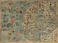
Caerte van Oostlant

The "Caerte van Oostlant" Woodcut in 3rd Edition (1 MB). A 4 MB version
here
The "Caerte van Oostlant" is a printed portolan chart of the North- and Baltic Sea of 1543.[1] The Caerte depicted area begins where the medieval portolans ends and has similar accuracy like the 14th century portolans.
The Caerte has as a latitude and longitude grid with a much larger error than the coastline shape. The three editions within 20 years show a serious deterioration in parts of the coastline shape.
Metrics, Preservation & Reproductions
The first edition of 1543 is only extant by copper engravings from Venice. The oldest is the "Septentrionalium regionum... descriptio" by "Michaelis Tramezini" of 1558 and one print is at the University Library of Rostock, Germany. It is of 520 x 380 mm.[2]
The best reproduction is at plate XXXIV in Nordenskiöld`s Periplus of 1897.[3] Later copper engravings are from Venice too. One 1572 is in reduced size in Nordenskiöld`s Facsimile-atlas as Fig. 25 and catalog entry 32 by "Ioannem Franciscum Camocium", 520 x 384 mm. There is a very same edition without the name of Camocium on the map.
A complete 9 sheet original woodcut print, only slightly superficial colored, of the Caerte third edition is preserved in the Bibliotheca Augusta of Wolfenbuettel, Germany. The outer rim is 1040 x 785 mm. The inner border of the cartographic image is 965 x 730 mm. It is reproduced in reduced size as single large sheet paper attached to the back cover page of Lang (1986).
Â
Author
According Abraham Ortelius (1570), the editor of the first modern atlas, Cornelis Anthoniszoon was the author of the "Caerte van oostlant".[4]
The writing of the name differs from Cornelius Antonij (Ortelius) to Cornelis Anthonisz. or Anthoniszoon.[5]

Cornelis Anthoniszoon in a self portrait of 1533.
In 1558 the 3rd edition of his pilot book "Onderwijsinge vander zee" was published. There he mentioned that in 1543 - by allowance of the Emperor - he published the "Caerte van Oostlant". He wrote he got advice by a sailor with 50 years experience and asked known navigators. He further consulted special literature.[6]
In a 1533 painting "De Braspenninckmaaltijd" he is in the background of his Amsterdam rifle association and estimated to be around 25 years old. It is assumed that the known artist Jacob Cornelisz van Oostzanen was his grandfather. The oldest record Anthoniszoon is mentioned is from 1527 in Amsterdam. In the next one from 1533 he is called a painter. In 1538 and 1544 he draw a city map of Amsterdam.
His Caerte contains so much accurate details that it is assumed he travelled by ship the coast of the North- and Baltic sea around 1540. In a 1544 printed pilot book by Anthoniszoon for the Caerte some coast points viewed from a ship with characteristic details are given as woodcuts. That supports his presence their unless he got it by a sailor as paper sketches for his woodcut. There is no record that he was himself ever a sailor or in any nautical profession. It is assumed he took in 1552/53 part in a military campaign of the Emperor because he left very detailed but unfinished sketches of the siege of Therouanne.
His last painting, unsigned but attributed to him is from 1556. In 1557 his wife is recorded as widow. So Lang assumed he died in 1557.[7] He left a considerable number (around 100) of paintings, wood- and copper cuts.
According Amsterdam city records he got in 1541 the order to prepare a hydrographical map of the Zuidersea and its sea gates. He got paid for it and the Caerte van oostlant in 1543 seems his next project. In 1543/44 he did a new order by the Dutch State, a map of the flooded area of the Putte district. So according the records he spent for the Caerte not more time than for a good large woodcut.
According Ortelius (1570) Cornelis Anthoniszoon produced a map called "Europa" too. Lang (1986) supposed it may be a sea chart but it is lost and nothing further is known about it.[8]
Â
Editions
First Edition
The first edition of the Caerte of 1543 is only known by copper engraved copies from Venice. The oldest known is called "Septentrionalium regionum... descriptio" by M. Tramezzino in 1558. That this is a copy of the the 1543 Caerte was explained by Lang (1985) with a note to J. Denuce (1912)[9] The catalog of Italian maps by R. V. Tooley (1939), is of the same opinion.[10]

A 1562 Venetian copper engraved copy by Camocius of the "Caerte van Oostlant" first edition (0.3 MB). A 1 MB version is
here
A second copy by another engrave is from Venice 1562. It has less and smaller decorations in the lower right and therefore there more cities and river details. This is evidence that the source of the Caerte was rather short on inland information. One 1562 print preserved in University Library Rostock, Germany, was used by Lang (1986). He considered it equal to the 1558 edition. Of this 1562 edition two different prints exist. One with the the name "Joannes Franciscus Camocius" in the lower part of the explanation box and the other version with an empty line there. That is the only alteration, it is still the same copper plate.
Second Edition
By comparing the Venice copy with the woodcut of the third edition Lang was able to identify evidence for a second edition. This second edition was done by C. Anthoniszoon and left typical style elements of his hand in new created, revised blocks of the woodcut. He added new names at the English coast and changed the shape of Norway in a very wrong way. Lang (1985) stated without doubt this was done by the hand of Anthoniszoon. The time of this edition he estimated around 1550, but certainly before his death in 1556 or 1557.
Third Edition

"Caerte van Oostlant" history of wood blocks in 3rd edition.
The third edition is the only one were a print of the woodcut is still extant. It was published in Amsterdam by the artist and publisher Arnold Nicolai around 1560. According Lang (1986), the lower left block got some changes but not England. The lower right got a new info box and some inland features were changed. Most notable is an update of the Netherlands. It seems based on the work by Jacob van Deventer, whose map was in print since 1536. The style of the letters and other details of the new blocks were not by the hand of Anthoniszoon. Therefore a date after his death is assumed. A bill of 1565 of a purchase of a Caerte print exists and Nicolai began to publish maps since 1558. So Lang (1985) assumed a date ca. 1560.
Â
Â
Accuracy and Errors

"Caerte van Oostlant" Overview 1st and 3rd edition in relation to modern map.
The first edition of the Caerte is of impressive long range over all accuracy like Nordenskioeld and Lang noted. The average coastline error (RMS) seems to be around 5 % if 100 % is the whole east to west extension. By correcting a c. 22.5° change of the English and German coastline rotation the average error at least for the western part may be down to around 1 %. Anyway the Caerte is in the accuracy range of a typical Mediterranean Normal Portolan like the Dulcert chart of 1339.
The latitude numbers in average were off by 15Â % of the map height. The longitude numbers by 68Â % of the map wide. Both scales have a large systematic error that is not present in the map coastline. Therefore neither the latitude nor the longitude numbers had any relation with the survey the map is based on. Like Lang suggested, this numbers were probably taken from a Ptolemy edition. That is remarkable because in 1543 latitude measurements with much better accuracy were well possible. But it seems still an uncommon practice in northern nautics.
By a first estimate the Caerte fits an equirectangular projection based on ca. 50° North. The mid parallel of the map is around 55° (55.75°) but a projection with 55° would not fit and a 45° one neither. So the Caerte is a cut from a larger map centred around 50° North or it got an error in the projection base by 5°.
Â
The Jutland Problem
The Caerte shows a rather unique portolan problem. Two large basins, the North- and Baltic Sea, were close together but separated by a long sea way around Jutland. From the town Cuxhaven at the south east corner of the North Sea to the Bay of Luebeck at the south west of the Baltic there is a sea way around Jutland of c. 1000 km. But the over land distance is only 150 km. The Caerte has the sea distance accurate to 3.5Â %, but the direct land distance only to 10Â %. The shortest land way from the North- to the Baltic Sea near Kiel with 80 km the Caerte had even 65Â % too large. So we face the typical portolan paradox that long ranges are much more accurate than short ones.
Inland errors beyond 10Â % are no surprise because Germany had no triangulated surveys yet. By the proven lack of any latitude measurements Lang like other historians suggested all positions on the Caerte were estimated by dead reckoning only.[11]
But unlike the straight courses inside the basins, like suggested by Anthoniszoon`s pilot book and assumed by Lang, a trip around Jutland would face a lot of different currents, winds and steerings. The principal problem is that even modern dead reckoning equipment on a 1980 motor ship, with gyro compass and electric log, has only a granted accuracy of 5Â %. It is therefore impossible for a ship of 1540 to get there any data in the 3.5Â % range.
An alternative explanation would be the use of latitude measurements that were lost until the map reached Anthoniszoon. But the Caerte, specially in the Baltic, is better in longitude than in latitude. The only possible conclusion seems that sometime data from latitude and longitude measurements were compiled to a map but only the shape of the coastline got transmitted to 1540.
Â
The Coastline Rotations

"Caerte van Oostlant" Errors in 3rd edition in relation to Gon grid.
The most obvious error of the first edition is the rotation of the English coast by 2 nautical points (22.5°). According Lang this is described in a 1541 pilot book the very same wrong way too.[12]
Lang could not explain the origin of such an error. Magnetic declination was never such large and there is no evidence it was involved anyway. In a course very close to north one would expect an orientation at the polar star. Any course 20° east or west of it would be hard to ignore.
From that perspective it is difficult to understand how such an error could be in a pilot book. Even more strange that it stayed there and for all three editions of the Caerte too. This is a strong contradiction to the assumption that the pilot book data was accumulated by generations of sailors.
There is further evidence that the distance and courses from the 1541 pilot book were derived from a map.[13]
In the North Sea are two further rotation errors. One in the 3rd edition at south Norway by 2 nautical points (22.5°). The other is in all editions at the West- and East Frisian islands chain. It could be less than 22.5° on the Caerte but well up to 22.5° on the Deslien 1541[14] and the Homem 1559 maps. The van Hoirne map of 1526 and the Olaus Magnus map of 1539 present a tradition of a correct orientation of these islands.
In the Baltic a rotation error west of Danzig is very obvious. It seems to be rather two times 2 nautical points or in sum 45° at its center. That local error totally screws the Bay of Danzig and shortens the maps east to west extension. It is the sole cause why the whole eastern Baltic coast is moved to the west. The error is centered as a bend at a straight part of the coastline. It is impossible to imagine any type of error in navigation or dead reckoning that may explain such a sudden break. There must be some other factor responsible for local sudden coastline rotations.
Less obvious is a fifth rotation error of the northern Baltic. The passages to the Gulf of Finnland and the Gulf of Bothnia are rotated by c. 45°. This is an important link to the Carta Marina, we will see later.
Relation to Gon Grid
All the first four rotation errors are related to a gon grid. The point of rotation for the English coast is close to 60 gon North and 20 gon East of Ferro. Ferro island is the historical most used longitude marker 18° west of Greenwich. The rotation point of the south Norway error is 65 gon North and 30 gon East of Ferro. The point of rotation for the Frisian islands could be 60 gon North and 30 gon East too. The bend in the Baltic is around 40 gon East.
The very same relation of rotation errors by 2 nautical points (22.5°) related to a 5 x 5 gon grid based on Ferro was found in several older Mediterranean portolans too.
The Norway Error
The most obvious error in the third edition is a shift of the west Norway coast almost 200 km to the west of its real position. Thats about twice the error the first edition already had. According Lang, the style of the woodcut reveals that both errors were done by Anthoniszoon himself. For the second edition he doubled it.
A close investigation of the third edition shows some hidden relations. The begin of the error is at the 22.5° rotation point at 30 gon East, 65 gon North. From here to 25 gon East the coastline seems to be doubled, drawn two times. About six features of the coastline can be identified in the same order in each of the 2.5 gon parts. A moderate distortion of the features may have fooled Anthoniszoon in thinking he had to insert a previously missed part of the coastline.
If the coastline is cut by one of the double 2.5 gon parts, the western shore of Norway will fit quite well the real geography. Such an error in the middle of a 5 gon longitude grid we find again in Mediterranean portolans at the Gulf of Hammamet and at the Bay of Antioch. In this examples the error is accompanied by a 22.5° rotation error too.
Â
Helgoland
(still in work)
Â
Â
Sources
A pilot book, a "written Portolan", published in Amsterdam 1541 had the very same obvious directional errors of some coastlines like the Caerte.[15]
In his own pilot book "Onderwijsinge" of 1558 (3rd Ed. posthoumus), where he mentioned his Caerte, Anthoniszoon wrote old sailors and nautical literature were his sources. That Anthoniszoon did himself sea voyages to collect local geographic knowledge is only an assumption based on the details he presented.
At the German Baltic coast the island of Ruegen and the Spree river document classical influence "for sure" (Lang). Lang suspects the use of a Ptolemy edition for inland details. For the 1543 first edition of the Caerte Lang denies any use of the 1539 "Carta Marina" of Olaus Magnus but suggested it for the second edition.
Lang concluded that the first edition sources were "few, of meagre content and error ridden". He considered assumed observations by Anthoniszoon himself as the main source. In that respect he agrees with the conclusion of other portolan researchers[16] that a pilot or portolan book can not create a portolan chart because it lacks details. But Lang still assumes that the over all long range accuracy of the Caerte was derived from the 1541 pilot book. That instead this pilot book was derived from a map he not even considers. But there is strong evidence for a map similar to the Caerte in 1541. Its line of development seems as obscure as that of the southern portolans before 1300.
Â
The Tradition of the North
The oldest sea chart of the North is the fragment of the Jan van Hoirne woodcut of 1526. Anything older are only printed Ptolemy editions from the the later 15th century. This poor preservation record opens the possibility that Ptolemy editions overwhelmed a prior tradition of manuscript charts up to extinction. Lang (1955)[17]suggested to look on the southern portolans from Italy and the "Catalan" tradition for traces of the northern tradition. Because the South was in close trade connection with the North, by sea and by land, any chart of the North is expected to improve the portolans quite soon. Much like it happened after 1543.
By the use of Jutland as an easy to identify feature of the North, we find during the formation period of the southern portolans till ca. 1340 about 3 different shapes:
Â
The long Jutland

Jutland in typical portolan tradition.
By 1330 we find the Dulceto portolan (Pujades 2007, C7) with a Jutland much too large and too long stretched north. The German Bight does not exist and the North Sea is much to small. This erroneous shape will dominate the portolans till the Caerte in the mid 16th century. It was first used by Vesconte in 1318 (Pujades 2007, A3,9) but without a Baltic like in 1330.
The origin of this normal portolano feature is probably a southern high medieval Pomponius Mela map. The Vatican has a 15th century metal plate "Borgia XVI"[18] with the very same North like the 1330 chart. Almost certainly it dates from a map created before the first portolans.[19]
This map must be of some circulation in the south that it was soon accepted there to supplement an area were portolan maps were not available. It is therefore very probably a southern tradition.
Â
The button like Jutland

Jutland in Anglo-Saxon tradition on few portolans.
It was used in the Anglo-Saxon Cotton map of c. 1040, in an early Vesconte like world map and in another Vesconte of 1321. It popped up again in 1500 by de La Cosa. Here this maps are well evidence for a northern tradition.
The finger like Jutland

Jutland in finger like tradition on few portolans.
It is first known from still another Vesconte of 1321 (Pujades 2007, A4,1). It may be on the Brunetto Latini map[20] of around same time but of more true shape than any later till the 16th. century. The finger like in 1321 popped up again in a 1462 portolan by Petrus Roselli.[21]
It has the same correct rectangular shape of the German Bight like in 1321.
It is remarkable that Roselli before and after it always used the "long Jutland" shape. According Lang the "Seebuch" (Sea Book), a written northern pilot book or sailing direction of 1500, is close linked with the 1462 Roselli chart,[22] So the finger is probably a northern tradition too.
Conclusion
There was a map information flow from the north to southern portolans. This almost rules out that the north had any maps of portolan like accuracy of the north in circulation - like the south had after 1311. This view is support by the Seebuch of 1500. It gave no accurate details like the ones after 1541 and therefore makes a prior circulation of better maps unlikely. So the Ptolemy editions did not made a portolan like map tradition of the North extinct.
Â
The "Romweg" Map

The "Romweg" woodcut map by Erhard Etzlaub of 1500. Here in north up position.
In 1500 the German Erhard Etzlaub published his "Romweg" (Rome Way, way to Rome) map. It is mainly a Ptolemy. But rotated by one nautical point (11.25°) the southern North Sea coast fits well the real geography and is an improvement over Roselli. Anything else is a typical poor Ptolemy but this part is of portolan accuracy. It is good on long ranges and poor on short ones. The rotation of c. 11° is typical for southern portolans too. But here it fits an equirectangular projection on 50° whereas the southern portolans are on c. 35°.[23]
This coast part can almost certainly linked to a northern tradition. All southern portolans until the 1550s still show it in a much worse shape like before Roselli`s 1462 map. The improvement of Roselli was even discarded by himself. Much like Etzlaub - in a map of 1511 he used a more Ptolemy like shape. Probably this new shapes were not too old but too young. This Romweg coast could be the first trace of some northern Caerte like portolans.
Jan van Hoirne Map of 1526

Only extant fragment of the Jan van Hoirne map of 1526.
In 1526 the woodcut "Caerte van die Oosterscher zee" was published in Antwerp. The author was Jan van Hoirne. Of probably hundreds of prints, only the fragment of one is still extant.[24]
It shows the German Bight, south at top and is the oldest known example of Dutch chart making. According Lang it was a source for the Caerte of Anthoniszoon or both had a common source.[25]
The fragment fits to an equirectangular projection on 50° north like the Caerte. But it has not the rotational error the Caerte had on the western islands. So the known part of the van Hoirne map seems more accurate than the later Caerte. Judging by the three visible rhumb lines, the van Hoirne map covered a larger geographic area than the Caerte. Probably at least like the Olaus Magnus map.
Â
Olaus Magnus "Carta marina" 1539
The next step in northern cartography was a map collection by Jan Jansz alias de Paep of 1532 covering Europe from France (Bretagne) to the Baltic (Danzig). It is complete lost.[26]
Carta Marina of Olaus Magnus
More luck had the "Carta marina" by the Swedish bishop Olaus Magnus (1490 - 1557) printed as large 9 sheet woodcut in Venice 1539. Of the woodcut edition only two prints survived but more from later copper engraved editions. The last copper engraved edition was in 1572.[27]
In his book[28] to the map, Magnus wrote he compiled it because he was not satisfied with the maps of Scandinavia published in Ptolemys` Geographia.[29] Lynam noted that the meridians like the rhumb net were rotated on average 10.45° to the East. The only one compass rose (lower left) is at 12° to the East.[30]
According Lynam (without source) the magnetic declination in Uppsala (near Stockholm) 1535 was about 12° East. But recent archaeomagnetic models put it from 2° E to 5° East.[31]
According this models the declination 1500 to 1530 nowhere in the Baltic or North Sea went beyond 6° East.[32]
So the 12° East rotation is probably not related to the magnetic field. May be it was only a 1 point (11.25°) rotation found on other portolans too. The 4 points (45°) sudden (!) rotation of the northern Baltic was certainly a compilation error not related to magnetic declination. It is the largest compilation error found on portolans so far.[33] But the Caerte van Oostlant had in all editions the very same rotation error.
Lynam noted that the scale bar of the map was "much nearer to the [southern] portolan charts" than to the Ptolemy editions.[34] The over all accuracy of the main regional features he considered from "remarkably good" to "first time in something like its true direction and its true proportions". Others disagreed. Because of "very large distortions everywhere" Lang considered it useless for sailors.[35]

"Carta Marina" of Olaus Magnus in relation to modern map.
Placed over the 50° North equirectangular projection like found for the Caerte, the Carta Marina shows - excluding the western and northern borders - surprising accuracy. The southern coasts of the North and Baltic Sea and the eastern Baltic are in long and medium range more correct than in the later Caerte. The average error there is below 40 km, what is much like southern portolans.
Most errors of the Carta Marina are related to rotations. The main error of south Norway has similarities to the Caerte error there. Both have a section of the coastline doubled and a rotational error. But the rotation error in the Carta is larger and effects a larger area.
By his detailed study Lang is sure that the Carta was not the source for the Caerte. Only in the second edition Anthoniszoon used some details of the Carta.[36] But by the above cartometrics it is certain that Carta and Caerte had a common source.
Mercator and the Science Community
In 1538 Gerardus Mercator (1512 - 1594) created a world map still linked to the Ptolemy tradition regarding the North and Baltic Sea. A tradition accepted by most scientists since the mid 15th century. But only two years later in a 1541 globe[37] Mercator revised his map to the same shape like the Caerte of 1543 later presented.
Still in 1541 Nicolaus Desliens of the "Dieppe school"[38] of mapmakers published a map with a Jutland and Norway in shape between Olaus Magnus and Mercator. This portolan is still extent and has other unique features.[39]
Despite the Norway error Anthoniszoon introduced in ca. 1550, the shape like the 1543 edition spread to most other map makers, even to the Portuguese Andreas Homem in 1559. To keep Anthoniszoon as creator of the Caerte content, Lang suggested that Anthoniszoon must have shown Mercator a pre version of his Caerte. But here we face a principal plausibility problem.
We have no direct evidence that Anthoniszoon was anything but a good artist and first rate woodcutter. Mercator was considered the greatest cartographer of his time and the pupil of the well known cosmographer and mathematician Gemma Frisius. How could such a high scientist accept a map from a person like Anthoniszoon as better than his own and better than of other known educated men like Magnus?
It is much more probable that Anthoniszoon got the map sketch from Mercator and there is some evidence for a link between both man.[40]
Mercator was close linked with the scientific community of his time. In his world map of 1538 he used the very same realistic Antarctica like Oronce Fine, the first Professor of Mathematics at the Collège Royal in Paris, in his world map of 1531. This very puzzling shape of Antarctica is first known from the German mathematician Johannes Schoener of Nuernberg in 1523. Oronce Fine is known as a source for the Dieppe school too. So by all likelihood somewhere in this scientific circle the source for the Caerte popped up between 1539 and 1541.
Â
Mercator's Interpretation

South Atlantic on the Mercator globe of 1541.
In this 1541 globe Mercator gave an interpretation about portolans. The globe has several points that emanate lines and create partly a rhumb net like on medieval portolans or the planiglobe world maps of the 1500s. But Mercator did more than a decorative tribute. According Harvard university (website)who posses one original globe, the lines are curved like loxodromes.[41]
Mercator was a mathematician and could well envision such a type of line.[42] With this feature he suggested that the line net on portolans was a loxodrome net. And that he thought the portolans were surveyed by the direction measurements in dead reckoning navigation.[43]
In his famous 1569 world maphe therefore used a projection he thought the portolans originally had. It had portolan like lines but with the Mercator projection they were real loxodromes. So Mercator in 1541 had the same idea on portolans like Arthur Breusing in 1869. Therefore it seems Mercator developed his projection guided by the portolans.
It does not imply that Mercator thought the portolans to be contemporary products. He may anticipated a classical origin but thought it was surveyed by much more accurate compass navigation then.[44]
The Cipher Map
That this maps with different compiled North Sea and Baltic from 1539 to 1559 had a common source seems obvious. But a close look makes it impossible that this common source was a map. The rotation errors we find in all this maps could not happened by copying from a map.
The common source had to have the coastline in some coded, crypted way. By deciphering this "Cipher Map" the rotation errors and the doubling at Norway happened. The shortening of the Baltic east extension after the Danzig rotation error points to a coastline winded up along a 16 or 32 sided polygon disc. There is evidence that the southern portolans went through such a very same type of cipher map too. It seems that this cipher map was in a limited circulation after 1539. It was kept secret and instead the myth of dead reckoning was spread to explain the new cartographic data. Probably the cipher map itself was the decisive factor that let Mercator to suddenly abandon his map and accept the new outline. Like other evidence shows, it is very likely that the cipher map itself had a rhumb net to encrypt the coastline by a directional code. That would be a further inspiration for his portolan interpretation.
The cipher map may explain why it was first in the hands of Olaus Magnus. As bishop he was in control of the "Secret Courts". This was a very powerful but today less known institution of the Middle Age. Like the Inquisition but in a much more brutal way Secret Courts were in charge of hunting down witchcraft and magic. The cipher map probably looked like an instrument for dark rites. On unknown new things the Secret Courts had to consult their bishop. So the disc may got in Olaus Magnus hands.
This line along the Secret Courts may explain Mercators involvement too. The nominal head of the whole Secret Courts organisation was the Emperor. Whether that was the case in Sweden is unclear but Magnus left Sweden and lived in the area of Emperor Karl V, where he published his map. If the court of the Emperor got the disc he may have send it for evaluation to the most capable cosmographer of the Empire. That was Gemma Frisius and his pupil Mercator.
Find or Hidden Tradition?
After 1500 we saw the arrival of unexpected new cartographic maps: Antarctica by Schoener and Fineaus. Parts of South America or even Australia suggested for the Dieppe school. By Magnus and Mercator the northern extension of the southern portolans. Finaly Alaska and Hudson Bay by Lafreri. This could be all explained by the find of an old book from Roman times, in a grave for example. But there is cartometric evidence that points in another direction.
The Carta Marina and the Caerte have an equirectangular projection on 50° North. But the area on these maps is north of 50°. This is a strange error unless we have only the upper part of a map that went down the Atlantic too. Indeed that was the case. The Atlantic coast of the southern portolans did not fit well the equirectanular projection of the Mediterranean, what was around 35° North. Like Wagner first noted, the Atlantic was from another map with another scale.
So someone compiled the Atlantic of the northern map on the southern Mediterranean portolans. He was not aware of the error he did by matching different scales and projections. So this error did not happened in classical times but probably later in the Middle Ages. It happened before 1318, perhaps even in the 12th century.[45]
This error was not noted till 1403 but even then ignored by almost all chartmakers. That someone before 1318 could match this maps together points to a hidden line of tradition. That at least two different maps were in very limited circulation during the High Middle Ages. Traces of the northern one came to light in the 1500s, about 200 years after the southern portolans suddenly arrived from nowhere. The scientific ignorance of southern chartmakers[46] may locate this hidden tradition rather in the north.
The rotation errors in the southern portolans past 1300 are all the same. All based on the same compilation. So there is no evidence that a cipher map was in use there past 1300. But the different rotation errors of the above mentioned northern maps after 1500 makes it very likely that a cipher map was still around then in the north.
References
- That several early printed maps were all or in part portolans was first discovered by Nordenskioeld (1889).
- According Nordenskiöld, Facsimile-atlas (1889), entry 130, p. 122
- Later reprints of this book have it page folded what makes the near center area inaccessible.
- Ortelius wrote in the "Catalogus auctorum" of his "Theatrum orbis terrarum" that the map "Regionum orientalium Tabula" was by Cornelius Antonij of Amsterdam. Because Ortelius printed the Denmark part in his atlas, this "Regionum orientalium Tabula" can be identified with the "Caerte van oostlant".
- The later versions were both used by Lang (1986). The following is mainly based on him, Arend Wilhelm Lang (1909-1981). His posthumous published book seems the deepest study so far: Lang, Arend W.: Die "Caerte van oostlant" des Cornelis Anthoniszoon 1543, Hamburg 1986. Additional: Lang, Arend W.: "Cornelis Anthoniszoon (t 1557)", in: Neues Archiv fĂĽr Niedersachsen, Heft 5/6, Bremen (1953), pp. 219-242
- Lang (1986), p. 45
- Lang (1953), p. 221f
- Lang (1986) p. 19
- Denuce, J.: "Oud Nederlandsche Kaartmakers in betrekking met Plantin", Vol. I. (1912)
- Tooley, R. V.: "Maps in Italian Atlases of the Sixteenth Century", Imago Mundi III, (1939) pp. 12-47. Tooley did not mention Denuce as reference and did not state from what Caerte edition the Venice copy was.
- Lang (1986), p. 55
- Lang (1986), p. 44.
- Lang (1985), p. 49-52 mentioned a pilot book "Dit is die Caerte vander zee". Amsterdam (1541) as source for the Caerte van Oostlant. The English coast rotation by two nautical points is there too. But from Firth of Forth at the northern end of the rotated part a distance to Cape Lindesnes is given too. It is very unlikely that the distance measurment had an error just to short the distance by the rotation. So almost certainly both, rotation and distance, were extracted from a bad compiled map.
- About this map see the note at its next occurrence below.
- Lang (1986), p. 44
- First Steger (1896), latest Pujades (2007)
- Lang, A. Wilhelm: Traces of lost North European sea charts of the 15th century, in: Imago Mundi - The International Journal for the History of Cartography, Volume 12, Issue 1, 1955, pp. 31-44
- I`m very thankful to Tony Campbell who identified it and provided the following info: There is an account of it in Destombes, Mappemondes (1964), no.53.1, planche V. It has been dated from internal evidence to the rather long period 1410-53.
- Pomponius Mela wrote around the year 43 a short book about a travel to the north. It was transmitted to the Middle Age without a map. The Mediterranean in the original map of Borgia XVI is very different from portolans, any other map or reality. So it was a creation of its own. Had the portolans (or the Ptolemy) already be available there would have been no need to create something such unique.
- Oxford, Bodleian Library, Douce 319 fol. 8
- Pujades (2007), C64 & COR4.
- "The descriptions in the Seebuch largely tally with those in Roselli's chart so closely that the Seebuch provides us with the most important clue to the correct interpretation of several features of the chart, which otherwise would remain unexplained." Lang (1955), p. 40
- This Etzlaub part may fit to a 35° projection too. But less well and only without rotation. All southern portolans had a rotation of around 9° to 12°. A lack of rotation would point to a none southern tradition too. So either way, whether 35° or 50° based, it belongs to a northern tradition.
- Lang (1986), p. 17. The fragment is in the Gerneentearchief of Groningen.
- Lang (1986), p. 46 noted that both maps have the same ca. 50 km error regarding the position of the Jutland islands chain. The chain begins near Tondern instead near Husum.
- The known references raised even doubt whether it were maps or written descriptions only. Lang (1986), p. 17
- Nordenskiöld (1889), p. 60f. His reprint on page 59 is of this last edition.
- "History of the Northern Peoples", printed in Rome, 1555.
- Lynam (1949), p. 4
- Lynam (1949), p. 5
- Model PSVMOD 1 (2000) 1500: 6° E, 1600: 3° E, -> 1530 c. 5° E; Model HHK (1998) 1500: 2.5° E, 1600: 1° E -> 1530 c. 2° E. According graphics from http://www.phys.uu.nl/~vgent/magdec/archmag/archmag.htm
- Maximum declination was 10° East for model GUFM 1 (2000) in the North Sea in 1600. The previous models had only up to 6° East declination in 1600.
- The near Danzig rotation error is of a similar angle but affects a much smaller area.
- Lynam (1949), p. 6
- Lang (1986), p. 17
- Lang (1986), p. 40
- [(here)]
- There is a good wikipedia article on this school: here
- It is the oldest of the "Dieppe School" and the first with reference to Canada. It was not destroyed in World War II but got only some water damage. It is definitive dated 1541. After some doubts it was checked in 2002 by the curator of the map division of the Sächsische Landesbibliothek Dresden, Dr Georg Zimmermann. It was the result of an inquest by Derek Hayes he reported on http://www.maphist.nl in February 2002 under "Desliens 1541(?) world map".
- He further reported a very interesting statement by Sarah Toulouse, chief librarian at the Bibliothèque municipale de Rennes, France:
-
-
- "...There even is an argument for a 1541 date : on this map, Desliens depicted the discoveries of the first two travels of Jacques Cartier in 1534 and 1536, but nothing appears of the third travel, which occurred in 1541... But one would have to check precisely the West Coast of South America, where there might be interesting things about the date.
-
-
- I would say that the map could actually be from 1541, but in that case, Desliens would have depicted a more accurate Scandinavia and South America 10 or 15 years earlier than the other Norman cartographers."
- The original map (not the facsimile) is under "Objektdokument 70401907", "Nicolas Desliens. - Dieppe, 1541." at Sächsische Landesbibliothek - Staats- und Universitätsbibliothek Dresden, Kartensammlung, SLUB/KS A19883; Aufnahme: df_dk_0005150
http://digital.slub-dresden.de/ppn275078841
- The Caerte has the rotation error near Danzig in all versions and Mercator in his 1541 map (a globe) is the only other with this error.
- I read first about this on the website of Harvard about the globe. The images there were photographys from the globe and had therefore a distortion. Nordenskioeld (1897) wrote that unused gores of the 1541 globe were found 1868 and a photo-lithographic reproduction published 1875 by Malou. Nordenskioeld mentions geographic features but not the loxodromes. I never heard about this detail or its implications regarding portolans. But a closer look on the distortions of the Harvard images suggested they could be right. So I see no reason to doubt it.
- He probably had not the detailed math about it. But by the basic rule that the line had to cross any meridian or parallel under the same angle he could well handle it.
- Dead reckoning gives data for direction (by compass or today gyro) and range. By use of both data it is impossible to draw a larger map because the earth is not flat. By taking only the direction data one gets a map in Mercator projection. But in theory only if the data was almost free of measurement errors. Whether the direction could be measured more accurate than the distance is still an open question. But it seems Mercator thought that way and the portolan line net may have put his mind in the direction of directions.
- He know that a Nuremberg type clock could be used on ships to get the longitude. This was suggested by his teacher Gemma Frisius. But even around 1700 Isaac Newton doubted that ever an accurate clock could be build to do the job. Therefore Mercator probably thought the direction measurement was more easy to solve and done so by the ancients.
- The Pizigani 1367 chart with already a typical Atlantic is suggested a copy from an early 13th century portolan. Fischer, (1886) p. 91
- They ignored the magnetic declination and ways of latitude measurements until the 16th century (Campbell, 1987, p. 386). They were never clear to what type of mile the scale bar was and sometimes even confused the scale bars in an atlas.


