
La vaca cega desconfiada
_FRASE_TOP
| 30-12-2014 (3521 ) | Categoria: Mapes |

Published by Edinburgh John Batholomew & Son & Royal Scottish Geographical Society. No date
Quantity Available: 1
From: Mogul Diamonds (Nr. Wolverhampton, United Kingdom)
Seller Rating: 
About this Item: Edinburgh John Batholomew & Son & Royal Scottish Geographical Society. No date. Coloured facsimile reprint of the original map of Lancashire. Sheet size 60.5 x 51cm; print size 49.5 x 38.5cm. Mounted. Clean and undamaged. Postage could be difficult. Seller Inventory # 21573
Published by Edinburgh John Batholomew & Son & Royal Scottish Geographical Society. No date
Quantity Available: 1
From: Mogul Diamonds (Nr. Wolverhampton, United Kingdom)
Seller Rating:
About this Item: Edinburgh John Batholomew & Son & Royal Scottish Geographical Society. No date. Coloured facsimile reprint of the original map of Middlesex. Sheet size 60.5 x 51cm; print size 49.5 x 38.5cm. Mounted. Clean and undamaged. Postage could be difficult. Seller Inventory # 21574
Quantity Available: > 20
From: Gyan Books Pvt. Ltd. (Delhi, India)
Seller Rating: 
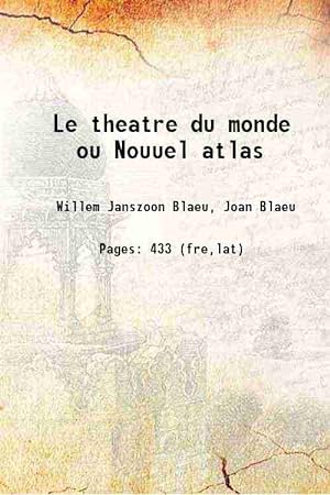
About this Item: 2018. Leather Bound. Condition: New. 433 SPECIAL DISCOUNTED PRICE DURING COVID PANDEMIC. Leather Binding on Spine and Corners with Golden Leaf Printing on round Spine. Reprinted in 2018 with the help of original edition published long back [1650]. This book is printed in black & white, sewing binding for longer life, Printed on high quality Paper, re-sized as per Current standards, professionally processed without changing its contents. As these are old books, we processed each page manually and make them readable but in some cases some pages which are blur or missing or black spots. If it is multi volume set, then it is only single volume, if you wish to order a specific or all the volumes you may contact us. We expect that you will understand our compulsion in these books. We found this book important for the readers who want to know more about our old treasure so we brought it back to the shelves. Hope you will like it and give your comments and suggestions. Lang: - French, Latin, Pages 433, Print on Demand. EXTRA 10 DAYS APART FROM THE NORMAL SHIPPING PERIOD WILL BE REQUIRED FOR LEATHER BOUND BOOKS. {FOLIO EDITION IS ALSO AVAILABLE.} Language: French, Latin. Seller Inventory # LB1111004703843
Quantity Available: > 20
From: Gyan Books Pvt. Ltd. (Delhi, India)
Seller Rating:
About this Item: 2018. Softcover. Condition: New. 433 {Size: 17.78 x 24.13 cms} Lang: - French, Latin, Pages 433, Print on Demand. Reprinted in 2018 with the help of original edition published long back [1650]. This book is Printed in black & white, sewing binding for longer life with Matt laminated multi-Colour Soft Cover {HARDCOVER EDITION IS ALSO AVAILABLE}, Printed on high quality Paper, re-sized as per Current standards, professionally processed without changing its contents. As these are old books, we processed each page manually and make them readable but in some cases some pages which are blur or missing or black spots. If it is multi volume set, then it is only single volume, if you wish to order a specific or all the volumes you may contact us. We expect that you will understand our compulsion in these books. We found this book important for the readers who want to know more about our old treasure so we brought it back to the shelves. Hope you will like it and give your comments and suggestions. Language: French, Latin. Seller Inventory # PB1111004703843

Quantity Available: > 20
From: Gyan Books Pvt. Ltd. (Delhi, India)
Seller Rating:
About this Item: 2018. Hardcover. Condition: New. 433 {Size: 18.78 x 25.13 cms} Lang: - French, Latin, Pages 433, Print on Demand. Reprinted in 2018 with the help of original edition published long back [1650]. This book is Printed in black & white, Hardcover, sewing binding for longer life with Matt laminated multi-Colour Dust Cover, Printed on high quality Paper, re-sized as per Current standards, professionally processed without changing its contents. As these are old books, we processed each page manually and make them readable but in some cases some pages which are blur or missing or black spots. If it is multi volume set, then it is only single volume, if you wish to order a specific or all the volumes you may contact us. We expect that you will understand our compulsion in these books. We found this book important for the readers who want to know more about our old treasure so we brought it back to the shelves. Hope you will like it and give your comments and suggestions. Language: French, Latin. Seller Inventory # 1111004703843
Published by Columns, Leeuwarden
Quantity Available: 1
From: Von Meyenfeldt, Slaats & Sons (Breda, Netherlands)
Seller Rating:
About this Item: Columns, Leeuwarden. Cloth. Condition: As New. Dust Jacket Condition: As New. Facsimile. Facsimile uitgave - De mooiste landkaarten uit de zeventiende eeuw van Joan Blaeu - 30 dubbele pagina grote gekleurde kaarten Size: 35x25cm. Seller Inventory # 006046

Quantity Available: > 20
From: Gyan Books Pvt. Ltd. (Delhi, India)
Seller Rating:
About this Item: 2018. Full Leather Bound. Condition: New. 433 Antique look with Golden Leaf Printing and embossing with round Spine completely handmade binding. Reprinted in 2018 with the help of original edition published long back [1650]. This book is printed in black & white, sewing binding for longer life, Printed on high quality Paper, re-sized as per Current standards, professionally processed without changing its contents. As these are old books, we processed each page manually and make them readable but in some cases some pages which are blur or missing or black spots. If it is multi volume set, then it is only single volume, if you wish to order a specific or all the volumes you may contact us. We expect that you will understand our compulsion in these books. We found this book important for the readers who want to know more about our old treasure in old look so we brought it back to the shelves. Hope you will like it and give your comments and suggestions. Lang: - French, Latin, Pages 433, Print on Demand. EXTRA 10 DAYS APART FROM THE NORMAL SHIPPING PERIOD WILL BE REQUIRED. Language: French, Latin. Seller Inventory # SD1111004703843
Published by Theatrum orbis terrarum (1973)
Quantity Available: 1
From: Ergodebooks (RICHMOND, TX, U.S.A.)
Seller Rating: 
About this Item: Theatrum orbis terrarum, 1973. Unbound. Condition: Used: Good. Seller Inventory # SONG9022112446

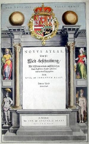
Published by Amsterdam (1634)
Quantity Available: 1
From: Libreria Antiquarius (Roma, Italy)
Seller Rating:
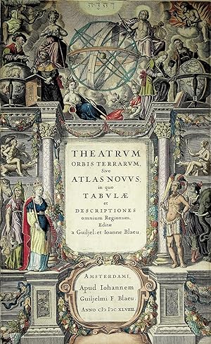
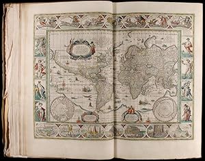
About this Item: Amsterdam, 1634. Frontespizio dell'edizione olandese dell"Atlas Novus" di Blaeu. Incisione in rame, bella coloritura coeva, in ottimo stato di conservazione. Title page of the Dutch edition of Blaeu's Atlas Novus. Copperplate with fine original hand colour, very good condition. 290 410mm. Seller Inventory # w335
Published by Blaeu 1649(orig 1635, Amsterdam (1649)
Quantity Available: 1
From: Quiet Friends IOBA (Lyndonville, NY, U.S.A.)
Seller Rating:
About this Item: Blaeu 1649(orig 1635, Amsterdam, 1649. RECENT, flawless, recoloring (illustrator). FINE main title page of the multi volumn atlas. Size inside mat 39cm X 23.5cm. Bright & very attractive hand coloring. This atlas first published in 2 vols in 1635. By 1655 it had expanded to 6. Matted & framed, under glass, likely with later hand coloring. Coloring superb. It is so good it likely had been professionally cleaned and recolored. FINE title page of the whole atlas, not just one of the parts. Seller Inventory # 001743
![Insulae Albion et Hibernia cum minoribus adjacentibus.: GREAT BRITAIN-Ireland]. MAP](https://pictures.abebooks.com/MCGAHERNBOOKS/md/md1422339660.jpg)
Published by Amsterdam. W. & J. Blaeu.1654-62. (1654)
Quantity Available: 1
From: J. Patrick McGahern Books Inc. (ABAC) (Ottawa, ON, Canada)
Seller Rating:
About this Item: Amsterdam. W. & J. Blaeu.1654-62., 1654. 47x 58.5cm, (image 38x 44cm; 15"x 17.5"), decorated cartouche, outline hand-coloured, Latin text on verso related to another map (Greenland), toning stripe along center fold, decorative watermark, cleaned with some fading to colour, some short tears on the margins, very good A very attractive map from Blaeus' "Atlas of Scotland" ( Volume V) first published in 1654. Book. Seller Inventory # 29381
Published by Thames & Hudson, London (1970)
Quantity Available: 1
From: Antipodean Books, Maps & Prints, ABAA (Garrison, NY, U.S.A.)
Seller Rating:
About this Item: Thames & Hudson, London, 1970. Condition: Fine in near fine slipcase. Limited edition. with an Introduction by R. V. Tooley and 115 Maps of Which 5 are coloured and Blaeu's title Pages in Colour. Elephant folio, unpaginated. Facsimile reprint of maps of John Blaeu of 1645 and 1654; a limited edition of 500 copies, of which this is number 242. Brown cloth covers, half red leather, with gilt rules, and gilt title on red spine. In a custom gray slipcase with dark brown edges; very good condition. Internally immaculate. Tooley states in the introduction, "known as the foremost mapmakers of their time, their fame was not confined to their native country of Holland, but reached into most of the cultured and leisured circles of Europe and even further, sumptuous examples of their atlases being sent as princely gifts to oriental potentates and ministers, as a symbol of the Republic of the United Netherlands.". Seller Inventory # 11772
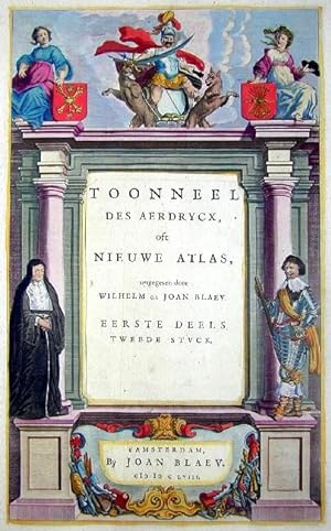
Published by Artist: Blaeu Willem Janszoon ( - 1638 ) Amsterdam; issued in: Amsterdam date: ca 1620 (1571)
Quantity Available: 1
From: Antique Sommer& Sapunaru KG (MĂĽnchen, Germany)
Seller Rating:
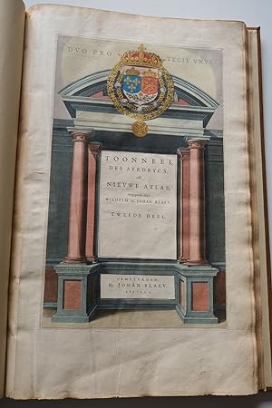
About this Item: Artist: Blaeu Willem Janszoon ( - 1638 ) Amsterdam; issued in: Amsterdam date: ca 1620, 1571. technic: Copper print; colorit: original colored; - condition: Tear on the left side perfectly restored; size (in cm): 33 x 20; Title page from the atlas.Toonneel de Aerdrycx oft nieuwe Atlas. Seller Inventory # T18_500
Quantity Available: 1
From: Kunstantiquariat Andreas Senger (Hamburg, Germany)
Seller Rating:
About this Item: 1647. Kein Einband. Condition: Gut. Es handelt sich hierbei um eine originale, altkolorierte Kupferstich-Titelseite aus Blaeus Nouvel Atlas , aus dem Jahr 1647. *** Titel: Le theatre du Monde ou Nouvel Atlas *** Gebiet bzw. Ort: Titelseite Kartograph: Willem Janszoon Blaeu (1571 - 1638) - Joan Blaeu (1596 - 1673) *** Jahr: 1647 *** Größe des Plattenbereichs: 40 cm x 25 cm *** Technik: Kupferstich *** Zustand (Perfekt/ Sehr gut/ Gut/ Ordentlich/ Mäßig/ Schlecht): In gutem Erhaltungszustand. Altersgemäß leicht gebräunt. *** Bemerkungen: Seltenes, sehr dekorativ altkoloriertes Titelblatt. Dargestellt sind im unteren Bereich des Blattes vier figürliche Allegorien der Kontinente (Asien, Amerika, Europa, Afrika) sowie im oberen Bereich in der Mitte eine Armillarsphäre flankiert von Apollo mit seiner Lyre, sowie Juno mit der Milchstraße. In der Mitte befinden sich zwei Geographen mit Erdgloben sowie Allegorien der vier Elemente Luft, Feuer, Erde und Wasser. - - - International buyers welcome. If you have any questions, please don't hesitate to ask. --- Auf Wunsch stellen wir Ihnen gerne ein kostenfreies Echtheitszertifikat aus --- If you wish, we will gladly provide a certificate of authenticity free of charge ---. Seller Inventory # 69556
Published by Artist: Blaeu Willem Janszoon ( - 1638 ) Amsterdam; issued in: Amsterdam date: ca 1620 (1571)
Quantity Available: 1
From: Antique Sommer& Sapunaru KG (MĂĽnchen, Germany)
Seller Rating:
About this Item: Artist: Blaeu Willem Janszoon ( - 1638 ) Amsterdam; issued in: Amsterdam date: ca 1620, 1571. technic: Copper print; colorit: original colored; - condition: Very good; size (in cm): 41 x 25; Titlepage from the Atlas of J. Blaeu. Seller Inventory # T22_500
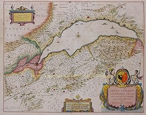
Quantity Available: 1
From: Inter-Antiquariaat Mefferdt & De Jonge (Amsterdam, Netherlands)
Seller Rating:
About this Item: "Lacus Lemanni Locorumquae Circumiacentium Accuratissima Descriptio" Kopergravure van het Meer van Genève uitgegeven door Willem Blaeu te Amsterdam als deel van zijn Novus Atlas, 1641-42. In de tijd met de hand gekleurd. Afm.: 41,5 x 52 cm. Deze prachtig gegraveerde kaart van de omgeving van het meer van Genève is gebaseerd op het werk van de Zwitserse theoloog Jacques Goulart (1580-1622). Talloze minutieuze details, zoals landgoederen, wijngaarden, parken, versterkte steden en kleine dorpjes zijn weergegeven, evenals aantekeningen over de pogingen van de hertog van Savoye om de controle over Genève te krijgen. Genève een belangrijke hanzestad, die in de Middeleeuwen handelaren uit Noord- en Zuid-Europa een marktplaats bood, was ook de stad waar een nieuwe golf van protestantisme ontstond die in de 16e-eeuw door Europa ging. De Fransman Johannes Calvijn (1509-1564) verspreidde vanaf 1641 zijn ideeën vanuit Genève en kreeg met zijn Calvinisme binnen enkele jaren voet aan de grond in Frankrijk, Duitsland en Nederland. Prijs: Euro 750,-. Seller Inventory # 2732
Published by Thames & Hudson, E-120 (1970)
Quantity Available: 1
From: Apollo Books (Charlottesville, VA, U.S.A.)
Seller Rating:
About this Item: Thames & Hudson, E-120, 1970. Unknown Binding. Leather. Elefant Folio. Thames and Hudson. 1970. 540 pgs. Illustrated with 15 Maps of Which 5 are coloured and Blaeu's title Pages in Colour. Facsimile reprint of maps of John Blaeu of 1645 and 1654; a limited edition of 500 copies, of which this copy is out of series. Bound in 3/4 red morocco leather with matching marble paper covered cloth. Leather has gilt titles with raised bands present to the spine. Boards very lightly worn to the extremities (spine lightly scuffed and worn). Text is clean and free of marks. Binding tight and solid. Tooley states in the introduction, "known as the foremost mapmakers of their time, their fame was not confined to their native country of Holland, but reached into most of the cultured and leisured circles of Europe and even further, sumptuous examples of their atlases being sent as princely gifts to oriental potentates and ministers, as a symbol of the Republic of the United Netherlands." . E-120; 16 pages. Seller Inventory # 53811
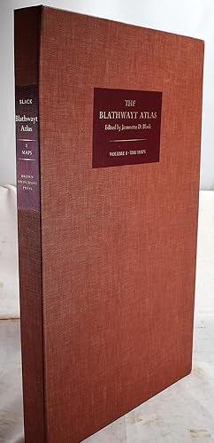
Published by Brown (1970)
Quantity Available: 1
From: Sequitur Books (Boonsboro, MD, U.S.A.)
Seller Rating:
About this Item: Brown, 1970. Hardcover. Condition: As New. First Edition. Volume 1 Maps. Fine Portfolio. A truly lovely collection. Large buckram solander box (25" x 15"). Maps are 70" x 23 1/4". 48 facsimile maps with descriptions. 8 maps printed in multicolor litholography. 40 reproduced by collotype. Hardcover. "The Blathwayt Atlas is a composite atlas consisting of thirteen manuscript and thirty-five printed maps, from various sources, dating from 1629-1683, which were probably bound together around 1683, that were in use by the office of the Committee of the Lords of Trade and Plantations. William Blathwayt was connected to the office of the Committee for Trade and Plantations from 1675 to 1696 and served thereafter as a member of the Board of Trade untll 1710. He also held the positions of surveyor and auditor general of the plantation revenues from 1680 until his death in 1717, and clerk of the Privy Council, Secretary of War, Secretary of State pro tem, and also served as a member of Parliament. By the time of his death the maps in this atlas were mostly out of date and were not retained and so this composite atlas survived in his personal library." List of the 48 maps: 1. Sellers' Map of the world; 2. To Capt. John Wood this map of the world drawn acording to Mercators projection is humbly dedicated by Robt. Morden & Willm. Berry [1676]; 3. A new map of the English plantations in America, both continent and ilands, shewing their true situation and distance, from England or one with another, by Robert Morden . and William Berry [1673]; 4. A chart of ye north part of America. For Hudson's Bay com[m]only called ye North West Passage. By Iohn Thornton. Iohn Seller. William Fisher. James Atkinson. Iohn Colson [London, 1677?]; 5. A new mapp of the north part of America from Hudson Straights commonly call'd the Norwest Passage including Newfoundland New Scotland New England Virginia Maryland & Carolena . by John Thornton [London, 1673]; 6. Le Canada, ou Nouvelle France . Par N. Sanson d'Abbeville [Paris, 1656]; 7. [Newfoundland and surrounding areas] [manuscript, before 1671?]; 8. [New England, showing Massachusetts boundaries] [1678]; 9. Novi Belgii Novaeque Angliae nec non partis Virginiae tabula multis in locis emendata a Hugo Allardt [Amsterdam, ca. 1656?]; 10. A mapp of Virginia Mary-land, New-Jarsey, New-York, & New England. By John Thornton . and Robert Greene [London, 1678-1679]; 11. A map of New England New Yorke New Iersey Mary-land & Virginia sould by Robert Morden . and by William Berry [1676]; 12. A map of New England New Yorke New Iersey Mary-land & Virginia sould by Robert Morden . and by William Berry [1676]; 13. A mapp of New Jersey, in America, by John Seller, and Willaim Fisher [London, 1677]; 14. Long Iland Sirvaide by Robartte Ryder [manuscript, 1679?]; 15. A map of some of the south and eastbounds of Pennsylvania in America, being partly inhabited, sold by John Thornton . and by John Seller [London, 1681]; 16. [Maryland by Augustine Hermann] [manuscript, 1677?]; 17. [Virginia by Augustine Hermann] [1677?]; 18. [Carolina from Roanoke River to below Hilton Head] [manuscript, 1664]; 19. [Carolina from Cape Hatteras to below Cape Romain] [manuscript, 1662]; 20. [Caroline from Cape Henry to Saint Augustine] [manuscript, 1677?]; 21. [Albermarle Sound, North Carolina, made by James Lancaster 1679] [manuscript, 1679]; 22. A mapp of Virginia discouered to ye hills, and in it's [sic] latt: from 35. deg: & 1/2 neer Florida, to 41. deg: bounds of New England. John Goddard sculp: [London, 1651 or 1652]; 23. To the right honorable Will. Earle of Craven, Pallatine and the rest of ye true and absolute lords and proprietors, of the province of Carolina. This map is humbly dedicated by Ioel Gascoyne. A new map of the country of Carolina . Sold by Ioel Gascoyne [London, [1682-1683]; 24. A mapp or Description of Sommer Islands sometime called Bermudas lying in the West Indies . [by Richard Norwood, manuscript, 1678]; 25. A chart of the Caribee Islands by Iohn Seller [ca. 1675]; 26. Les Isles Antilles &c. entre lesquelles sont les Lucayes, et les Caribes, par N. Sanson d'Abbeville] [Paris, 1656]; 27. Carte de lisle de Sainct Christophle scituee a 17 degrez 30 minutes de lat. septentrionale [Paris, ca. 1677]; 28. L'isle de la Martinique scituee a 14 degrez 30 minutes de latitude septentionale [Paris, ca. 1667]; 29. The island of Tobago by John Seller [London, 1682-1683, which is not included in Index]; 30. Mountserrat Island 1673]; 31. Isle de la Guadeloupe scituee a 16 degrez de lat. septentionale [Paris, ca. 1667]; 32. A new map of the island of Barbadoes wherein every parish, plantation, watermill, windmill & cattlemill, is decribed with the name of the present possessor, and all things els [sic] remarkable according to a late exact survey therein [London, 1675-1676]; 33. Jamaicae descriptio F. Lamb sculp. [ca. 1675]; 34. Tabula Iamaicae insulae per Edwd. Slaney [London, 1678]; 35. Novissima et accuratissima Jamaicae descriptio per Johannem Ogiluium. F. Lamb sculp [London, 1671]; 36. A new mapp of Jamaica. According to the last survey . James Moxon sculp. [London, 1677]; 37. Venezuela, cum parte australi Novae Andalusiae. Guiljelmus Blaeuw excudit. [Amsterdam, between 1629-1662]; 38. [Surinam of Commewijne Rivers] [manuscript, 1667 or later]; 39. Caerte ofte vertooninge van de riuieren van Suriname en Commewijne met verscheyde creken uyt deselue spruijtende als Para Surinoo en Cotteca ende ander meer gelyck die nu tegen woodich bewoont verden [Amsterdam, 1671]; 40. Accuratissima Brasiliae tabula . Joannes Janssonius excudit [Amsterdam, 1650 or later]; 41. Paraguay, o Prov. de Rio de la Plate cum regionibus adiacentibus Tucuman et Sta. Cruz de la Sierra . Excudebat Ioannes Ianssonius [Amsterdam, between 1630 and 1666]; 42. A new map of Magellan Straights discovered by Capt. John Narbrough. (Com[m]ander then of his His Majesties ship the Sweepstakes.) as he sayled through the sade straights. By John Thornton Iohn Seller William Fisher James Atkinson Iohn Co. Seller Inventory # 2003240003
Quantity Available: 1
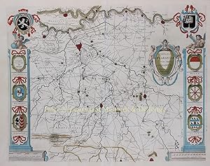
From: Inter-Antiquariaat Mefferdt & De Jonge (Amsterdam, Netherlands)
Seller Rating:
About this Item: BEROEMDE WAPENKAART VAN DE MEIERIJ VAN DEN BOSCH "Quarta Pars Brabantiae cujus caput Sylvaducis"[het vierde deel van Brabant met als hoofdstad s-Hertogenbosch], kopergravure van het oostelijke deel van Noord-Brabant, gecentreerd op Den Bosch en Eindhoven, uitgegeven te Amsterdam door Willem en Joan Blaeu als deel van Le Theatre du Monde ou Nouvel Atlas, 1634-1635. In de tijd met de hand gekleurd. Afm. 41,5 x 52 cm. Deze zgn. wapenkaart van de Meierij van s-Hertogenbosch, vervaardigd door Willebordus van der Burght, is vanwege zijn decoratieve wapenschilden en nauwkeurige topografische gegevens een van de meest geliefde kaarten uit de atlassen van de firma Blaeu. Behalve de wapenschilden van Brabant en Den Bosch (met twee Brabantse en twee Limburgse leeuwen) bovenaan, zien we de wapens van Helmond, Eindhoven, Graafschap Megen, het Land van Ravestein en Grave. Prijs: Euro 1.650,- (incl lijst). Seller Inventory # 2775
Published by t'amsterdam Johan Blaeu 1650 (1650)
Quantity Available: 1
From: Charles Russell, ABA, ILAB, est 1978 (Cirencester, United Kingdom)
Seller Rating:
About this Item: t'amsterdam Johan Blaeu 1650, 1650. Folio 21 x 14 1/2 inches, handsomely bound up in full recent calf with gilt. Bound with the general architectonic title page in fine original hand colour heightened with gold. Text in Dutch. 48 FINE HAND COLOURED, DOUBLE PAGE MAPS - being 1 general map of France, 44 regional maps of France, a large folding general map of the Mediterranean and two maps of ancient Gaul. THE FRENCH SECTION COMPLETE- with accompanying text. IN FINE CONDITION. This Dutch edition comes with exceptionally FINE FRESH ORIGINAL HAND COLOURING. Seller Inventory # 5155
![Atlas of Italy] Guil. et Joannis Blaeu: BLAEU Willem Jansz.;](https://pictures.abebooks.com/MAGGS7/md/md30447192978.jpg)
Quantity Available: 1
From: Maggs Bros. Ltd ABA, ILAB, PBFA, BA (London, United Kingdom)
Seller Rating:
About this Item: 1645. Large Folio (500 x 336 mm); engraved title-page with letter-press paste-over; sixtytwo engraved maps, all but one double-page, comprising fifty-eight of Italy and its regions, and four of Greece and regions, including Crete. 18th century mottled calf, seven raised bands, gilt floral tooling and gilt lettering to spine. Both joints split (binding still holding), boards and spine worn, tooling and lettering faded. Amsterdam : Johannes Blaeu, The Blaeu family were the pre-eminent Dutch atlas-publishers of their period. The family published their first terrestrial atlas in 1630, with the multi-volume Atlas Novus launched in 1635. They continued to enlarge the atlas over the next thirty-five years, adding new maps to expand sections, but also preparing separate volumes devoted to England and Wales, Scotland and China. This is the third volume of the Atlas Novus, devoted to Italy, the coverage of that county expanded to almost fill an entire volume, with a small section at the end of Greece. Although not technically an atlas of Italy, the suite of maps relating to Italy and its provinces represents the next geographic advance on Giovanni Antonio Magini?s atlas Italia ., the first separate printed atlas of Italy, first published in 1620 and reissued in 1632. The maps are accompanied by a descriptive geographical text in Latin. Reference: Koeman, BL 37A; the index calls for a section with maps of Scotland and Ireland but this is not, and never was, present, as usual when this volume was issued in the set with the England volume, where the maps were placed. Seller Inventory # 223306
Published by Amsterdam (1648)
Quantity Available: 1
From: Donald A. Heald Rare Books (ABAA) (New York, NY, U.S.A.)
Seller Rating:
About this Item: Amsterdam, 1648. Folio. (20 3/4 x 13 inches). French text, letterpress title on slip within hand-coloured engraved architectural border, heightened in gilt, 60 engraved general and county maps (59 double page) including general maps of Scotland and Ireland preceded by a printed divisional half-title (not called for in the index at end), all finely coloured by a contemporary hand, 71 illustrations (3 hand-coloured). Contemporary red morocco, paneled in gilt with fillets and decorative rolls, the inner panel with elaborate blocked cornerpieces of stylized scrolling foliage, a blocked central oval of scrolling flowers and foliage enclosing a small blank oval, the spine gilt in eight compartments with raised bands, each compartment with a central rose flower-head tool and a small flower-spray tool at each corner, green cloth ties, gilt edges, modern tan cloth box, brown morocco lettering-piece. An unrecorded variant edition of Blaeu's atlas of England and Wales, in a magnificent contemporary red morocco binding. The fifty-eight maps normally found in the French editions are supplemented by an appendix with a half-title and two new maps. These new maps are general maps of Scotland and Ireland, which were the first two maps completed for Blaeu's atlas of Scotland. The forthcoming publication of the Scotland atlas is announced on the half-title, but it did not appear on the market until 1654 (as volume 5 of the Theatrum). Neither Koeman nor Skelton mention a French edition with this appendix, which is normally found in the Dutch-text edition of 1647 (Koeman B145B). The ephemeral nature of this edition is confirmed by the fact that the supplement is not mentioned in the index at the end. The present atlas is volume four of the six-volume French text edition of the Theatrum (or Théâtre du Monde). The volumes of the Theatrum were published separately from 1635 to 1655. Volume 4 was introduced with French text in 1645. In its completed form, the Theatrum was the finest and most accurate atlas yet to have been published. Koeman I, Bl-42 C (not calling for the extra maps of Scotland or Ireland present here); Skelton 43. Seller Inventory # 2590
Published by Blaeu, Amsterdam (1655)
Quantity Available: 1
From: Arader Galleries - Aradernyc (New York, NY, U.S.A.)
Seller Rating:
About this Item: Blaeu, Amsterdam, 1655. Part II "Americas" of volume II (of 6) only, folio (20 4/8 x 13 6/8 inches). Text in Latin. Engraved title with letterpress title overslip, 15 engraved double-page maps ALL FINELY COLORED IN A CONTEMPORARY HAND, woodcut tail-pieces and initials (some light browning and spotting, a few marginal tears). Contemporary Dutch paneled vellum (remboitage), each cover elaborately decorated in gilt in two panels with fillets of broad floral roll tools, large floral inner corner-pieces and central floral medallion, yapp edges, all edges gilt (rebacked, lacking two pairs of ties, front cover with small split in fore-edge, one or two small stains). Provenance: Richard Green Library of Important Scientific Books, his sale, Christie's New York, 3rd December 2007, lot 256. A FINE TALL COPY WITH EXCEPTIONAL HAND-COLORING. An important part of the Latin edition of Blaeu's "Theatrum orbis terrarium." Containing fine large maps of "Americae," "Insulae Americanae," "Nova Belgica et Anglia Nova," "Barmudas," "Nova Virginiae," "Virginiae . et Floridae," "Nova Hispania et Nova Galicia," ".Novum Regnum Granatense et Popayan," "Venezuela, cum. Novae Andalusiae," "Guiana sive Amazonum Regio," "Brasilia," "Paraguay, o Prov. De Rio de la Plata cum. Tucuman et S.ta Cruz de la Sierrra," "Magellanica," "Chili," and "Peru." Of particular interest is the map of "Nova Belgica et Anglia Nova": "It's primary source is the first manuscript figurative map of Adrien Block, 1614. Indeed it is the first full representation of it in print. It is one of the earliest to name "Nieu Amsterdam" (Burden). Publication of this New World Atlas, or "Atlas Novus" was originally begun by Joannes's father Willem Blaeu with the publication in 1635 of two volumes (consisting of The World, Europe, Arctic, Scandinavia, Russia, Eastern Europe, Germany and the Low Countries; and France, Spain, Asia, Africa and America), and published in four languages (German, Dutch, Latin and French). After succeeding his father, Joannes Blaeu progressively expanded the "Atlas Novus" to six volumes by 1655, and this formed the first half the "Atlas Maior," extending to 11 or 12 volumes by 1662. Burden 241 and 242; Koeman I, Bl 24C. Seller Inventory # 001908
Published by [Amsterdam: Joannes and Willem Blaeu, 1655]. (1655)
Quantity Available: 1
From: Arader Galleries - Aradernyc (New York, NY, U.S.A.)
Seller Rating:
About this Item: [Amsterdam: Joannes and Willem Blaeu, 1655]., 1655. Full Vellum. Condition: Very Good. 1st Edition. Complete title: Novus atlas sinensis a Martino Martinio Soc. Iesu descriptus et serenessimo archidvci Leopoldo Gvilielmo Avstriaco Dedicatvs. Cum privilegio S.C. Maj. et Ordd. Foed. Belg. Folio (21 x 14 inches). Engraved allegorical title-page with original hand-colour HEIGHTENED IN GOLD (creased, edges a bit frayed), 17 fine double-page engraved maps of Asia with original hand-colour in outline (2x1 with long tear crossing the text repaired in the margin at an early date, map of Japan a bit spotted as are some text leaves, one map with short closed tear, some lower margins with pale waterstains). Contemporary Dutch gilt panelled vellum over thin paste-board with yap fore-edges, all edges gilt (lacking two pairs of ties, lightly soiled but ATTRACTIVE). FIRST AND ONLY DUTCH EDITION OF VOL. VI OF BLAEU'S SIX-VOLUME NIEUE ATLAS DEPICTING THE CHINESE EMPIRE, ITS 15 PROVINCES, AND JAPAN. The Novus Atlas Sinensis was compiled by the Italian Jesuit Martino Martini (1614-1661), and it is the first atlas of China produced in the western world, the first comprehensive visually descriptive work on China with accompanying historical texts, perhaps the first true Sino-European publications, based as it was on Chinese land surveys, and was the first of very many illustrated works and translations of works about China in the 17th and 18th centuries. "The seventeen maps are noteworthy not only for their accuracy, remarkable for the time, but also for their highly decorative cartouches featuring vignettes depicting regional Chinese dress, activities and animals. Along with the maps, the volume contains 171 pages of Latin text by Martini comprising a preface on the Far East and descriptions of each province in China as well as the Liaodong and Korean peninsulas and Japan. Also included in the volume are two separately paginated works: Jacobus Golius's De Regno Catayo Additamentum ("An Addition on the Chinese Reign") and Martini's De Bello Tartarico Historia ("History Concerning the Tartar War," 1654), both of which were also published as separate titles" (Reed and Dematte, p. 188). Martini set out for Asia in March 1640, "traveling initially to India, reaching Goa later that year, and then to China, reaching Hangzhou in 1643. After impressive missionary works--baptizing hundreds of converts in Hangzhou--Martini was called back to Rome in 1650 to represent both the accomplishments of the Jesuit mission in China and its needs. En route to Rome, he landed in Amsterdam in 1654, where he met Blaeu, and they worked together to create the Novus Atlas Sinensis. Martini had brought with him copies of Chinese atlases, among them Luo Hongxian's Guangyu tu ("Englarged Terrestrial Atlas," 1579), a Ming-dynasty atlas (based on the monumental Yuan-dynasty map compiled by Zhu Siben between 1311 and 1320) that included, apart from the general map of China, maps of the various provinces and border regions. Martini finally reached Rome at the end of 1655 but set out for China in 1657. He died in Hangzhou in 1661" (ibid.). The Blaeu family firm was founded by Willem Janzoon Blaeu (1571-1638) in 1596. He was eventually joined by his sons, Cornelius (1616-1648) and Joannes (1596-1673). The firm became the most productive cartographic establishment in the Netherlands until it was destroyed by fire in 1672. The elder Blaeu initiated the great series of atlases that culminated in the Atlas Maior, in which Joannes Blaeu incorporated much of the geographical knowledge bequeathed him by his father. REFERENCES: Koeman 2:521A; Marcia Reed and Paola Dematte, "China on Paper," Getty Research Institute, 2007. Catalogued by Kate Hunter. Atlas. Seller Inventory # 72lib202
Published by Amsterdam (1645)
Quantity Available: 1
From: Donald A. Heald Rare Books (ABAA) (New York, NY, U.S.A.)
Seller Rating:
About this Item: Amsterdam, 1645. 4 volumes, folio. (20 x 13 1/2 inches). 334 copper-engraved maps with very fine period hand-colouring. Original publisher's vellum, panelled in gilt with central gilt arabesques and corner pieces, cloth ties, modern black morocco-backed cloth boxes, gilt spines An early edition of the greatest world atlas ever produced. The Theatrum Orbis Terrarum (or Theatre du Monde, in French) marks the intermediary stage in the development of the "greatest and finest atlas ever published" (Koeman). In 1630, Willem Janzzon Blaeu, the official cartographer of the Dutch East India Company, published his first world atlas, the Atlantis Appendix, with 60 maps. The second expanded edition, with 99 maps, appeared in the following year. Blaeu continued to produce new maps at such a rate that by 1634, he abandoned the single volume format, and announced his intention to publish a new world atlas, entitled the Theatrum. This atlas, which originally incorporated most of the maps from Blaeu's Appendix, was expanded so rapidly that by 1646, when this version appeared, it consisted of four volumes with 334 maps. The acclaim that Blaeu's atlas has always received is based primarily upon its extremely high production standards. The quality of the engraving, the paper, and colouring are of the highest order, and place it in the first rank among seventeenth century illustrated books. The maps are embellished in the Baroque style, and many rank among the most beautiful ever made. Of particular note are the famous side-panelled maps of the world and four continents, sixty devoted to Great Britain (Volume IV), the map of the environs of Frankfurt (Volume I), a fine map of China and Japan (Volume III), and a series of thirteen maps of America (Volume III) that includes early and important maps of New England and the Chesapeake Bay. Volume I. Le Theatre du Monde, ou Nouvel Atlas Contenant Les Chartes et Descriptions de tous les Pais de la Terre Mis en Lumiere Par Guillaume et Jean Blaeu. Amsterdam, Johannem Guiljemi F. Blaeu:1645. Folio, two title pages, 120 maps (Koeman Bl 19B). The number and order of the maps is the same as in the French edition of 1638 (Koeman B1 16A), but with altered signatures and page numbers. Part I: World map, plus 83 maps of Germany, Scandinavia, the Arctic and eastern Europe, several oversized and folding. Part II: 36 maps of the Lowlands. Volume II. Le Theatre du Monde, ou Nouvel Atlas Mis en lumiere par Guillaume & Jean Blaeu. Seconde Partie. Amsterdam, chez Jean Blaeu: 1645. Large folio, two engraved title-pages with each title printed on slip of paper, laid down, 92 maps. (Koeman B1 18C) Collation is the same as in the French edition of 1640 (Koeman B1 17), but with altered (corrected) signatures and page numbers: Part I: 48 maps of France; Part II: 14 maps of Spain and Portugal, 12 maps of Asia, 5 maps of Africa, 13 maps of America. Volume III. Le Theatre du Monde, ou Nouvel Atlas mis en lumiere par Guillaume & Jean Blaeu. Troisieme Partie. Amsterdam, Chez Jean Blaeu: 1645. Folio, 62 maps, engraved title-page with title printed on separate slip of paper, laid down. (Koeman Bl 35F) Collation is the same as the first French edition of 1640 (Koeman Bl 35A): 58 maps of Italy and four maps of Greece. The register at the end calls for an additional four maps of Great Britain, which had been added as a supplement to the second French edition (also 1640). With the introduction in 1645 of volume IV, devoted solely to Great Britain, they were removed. Volume IV. Guil. et Joannis Blaeu Theatrum Orbis Terrarum, sive Atlas Novus, pars quarta. Amsterdam, apud Johannem Blaeu: 1646. Folio, 60 maps, several engravings of British antiquities interspersed throughout the text, engraved title page with title printed on separate slip of paper, laid down. (Koeman B1 42B) "This edition of 1646 is identical with the former [first] edition of 1645" (Koeman Bl 42A). In point of fact, this volume contains two maps, one of Scotland, the other of Ireland, that are not called for in the index. It also varies in that the inlaid title slip is in Latin rather than in French. Koeman Bl 19B; 18C; 35A; 42B. Seller Inventory # 6850
Published by Amsterdam: Joannes and Willem Blaeu, 1649 - 1647 - 1648 - 1654 - 1656. (1656)
Quantity Available: 1
From: Arader Galleries - Aradernyc (New York, NY, U.S.A.)
Seller Rating:
About this Item: Amsterdam: Joannes and Willem Blaeu, 1649 - 1647 - 1648 - 1654 - 1656., 1656. 6 volumes. Folio. 8 engraved allegorical title-pages, all but the first with printed overslips for the title and or imprint, all with EXCEPTIONAL ORIGINAL HAND-COLOUR HEIGHTENED IN GOLD, PROBABLY BY FRANS KOERTEN AND HIS STUDIO. 404 engraved maps, the majority double-page, seven folding, and some full-page, all with original hand-colour in outline, and all mounted on guards (map of Lithuania in volume one with expert repairs to folds, minor marginal tears to three maps, not affecting the images, pale marginal waterstains to the first third of volume one, volume V - Scotland - very browned, and volume VI - Asia - quite browned). Contemporary Dutch vellum over paste-board, elaborately decorated in gilt, with remains of 12 pairs of silk ties (small chip in backstrip of volume V, extremities a bit scuffed, spines lightly soiled, early bookplate removed from each paste-down). Provenance: 20th-century manuscript ex-libris on front paste-down of each volume. A FINE LARGE PAPER DELUXE COPY PROBABLY COLOURED BY FRANS KOERTEN AND HIS STUDIO. The German edition of Joannes and Willem Blaeu's "Novvus atlas", first published as three-volumes in 1641-1642 (world, the continents including fifteen maps of the Americas, northern and eastern Europe, Italy and Greece); they enlarged it to four volumes in 1646 (England); published a new edition with four volumes in 1647; and then enlarged that to five and six volumes in 1654 (Scotland) and 1655 (China) respectively. The Blaeu family firm was founded by Willem Janzoon Blaeu (1571-1638) in 1596. He was eventually joined by his sons, Cornelius (1616-1648) and Joannes (1596-1673). The firm became the most productive cartographic establishment in the Netherlands until it was destroyed by fire in 1672. The elder Blaeu initiated the great series of atlases that culminated in the "Atlas Maior". Truusje Goedings, renowned expert in Dutch colourists of the 17th-century writes of this copy: "Contemporary colour in a style very characteristic for the Blaeu atlases before the 'Atlas Maior', ie between ca. 1635-1656, and initiated by Willem Blaeu I. Archival documents reveal that colored copies could be ordered at the Blaeu firm, and were made according Blaeu's instructions from the very start. The underlying principles were the same throughout (including the 'Atlas Maior'): a lavishly coloured title-page, often more or less heightened with gold; a functional colouring of the maps and a contrasting, more extensive treatment of the map decorations. Comparison shows that except for the title-pages, and independent of their degree of luxury, the maps of early copies were coloured more soberly and have a much more open and plain style. "This large paper copy in typical Dutch gilt vellum atlas bindings has extensively and expertly coloured title-pages, each lavishly heightened with gold especially in the first and fourth volumes, with a lively variety of colours and a careful handling of details such as fruitguirlandes and clothing of figures. The cartography of the maps is executed carefully but soberly, keeping the overall view rather white: the dividing or surrounding borderlines are in general drawn in single lines, in very pale hues of rosa, yellow and green; the detailed engraved mountain- or wooded regions are not worked out but indicated in the same way as the border lines with one very light and transparant (broader) stroke of pale green or umber. Small embellishments such as boats, waves, heraldry were given their special colours, places in the regions have red dots - signs that this colouring had a somewhat more than regular character. The larger decorations, such as legends and cartouches are often remarkably worked out. With a large variety of colours in bright and vivid combinations (see especially the Italy-volume, they produce a lively contrast with the dominant white of the regions). Comparison with one volume (5) of a coloured dedication copy (to Ferdinand of Liechtenstein, to which this edition al. Seller Inventory # 72lib27

Afegeix-hi un comentari: