
The studies
In 1987 I published in print (1) a study on the origins and history of Sapri. The study started in Salerno and then continued in Naples was conducted on various fronts. The scarce information that local historiography made available and the scarce archival sources of the time, made the results uncertain but, the search for new sources, deserved further investigation and investigation. Although today there is no memory of all this, this study sheds light on some peculiar aspects and characteristics that the harsh territory of the Gulf of Policastro has had over the centuries. As we shall see, the study of the few sources that have come down to us, even if they should be further investigated, returns a small but useful contribution to the history of the 'lower Cilento' and Sapri over the centuries. In the study drawn up for the Municipality of Sapri, for the drafting of the new P.R.G. of Sapri – now preserved in the Archives of the Municipality – I wrote and reported some news and documents that from a strictly bibliographic and historiographical point of view, remain of extreme interest. In this essay I write about the oldest known portolano: "lo Compasso de Navigare", an ancient membranous codex for use by sailors dating back to 1296 stolen by the Germans in Germany and now preserved in the Berlin State Library, called Hamilton code 396. Being a document datable around 1296, it is a testimony of enormous importance for the toponyms mentioned in it and for the history of our places and our coasts in the Angevin era.
The historiographical sources for toponymy in the early Middle Ages: nautical cartography, portolans and manuscript nautical manuals.
As is known, cartography (maps), manuscript of antiquity, can provide a valid contribution to the historiography of places and toponyms, to toponymy, as through a series of information contained in it it can be traced back to the age or presence of a place, such as its toponym in antiquity or its approximate location. The ancient manuscript cartography remains a valid testimony of the past of the places and of the geography more generally. The manuscript maps in antiquity are those inserted in some manuscript codes, the Codex or illuminated codes, those not printed but written by hand, which sometimes contained attachments of considerable importance such as maps or handwritten maps. For the historical reconstruction of our lands in the medieval period, from the beginning until the sixteenth century onwards, the sources or testimonies or documentation attesting to some historical facts are scarce. In particular, in the Middle Ages until the fall of the Catalan Kingdom of Naples, there are very few sources and testimonies lost in the various successive conflicts over the centuries. In fact, part of the Angevin and then Catalan documents were definitively lost with the fires of the Bourbon archives destroyed by the Napoleonic French. The archives and libraries of sites such as the Abbey of Cava dei Tirreni or Cividale etc have been saved... Of the few sources and documentation that have come down to us, medieval cartography, and with it the nautical charts and ancient portolans, represent valid testimonies for the study of toponymy of the time. Through the medieval toponymy, which appears on ancient maps, we can support some hypotheses on the existence or not of some ancient centers. It is believed that nautical cartography began in Italy, probably because of its central location in the Mediterranean Sea. The nautical charts or medial portolani and manuscript, were geographical maps drawn up by cartographers of the time for sailors. The approximately 180 nautical charts that survived in the period between 1200 and 1400, largely of Italian production, constitute a fundamental source of knowledge in the early medieval period for these lands. In the Middle Ages, the Genoese and Venetians were renowned compilers of portolans. The portolani of the oldest date, dating back to the Middle Ages, descended directly from the peripli of Greek and Latin origin: in classical times, in the absence of real nautical charts, navigation was carried out using books describing the coast, not necessarily intended for boating, but more often consisting of reports of previous voyages, or celebrations of the deeds of leaders or rulers. Unlike nautical charts, of which there are no traces in Greek and Roman times and of which the first specimens date back to the thirteenth century, the peripli and, subsequently, the portolani make use of an uninterrupted and substantially unchanged tradition that derives from centuries of use and experience. Portolans and nautical charts, are navigation maps based on compass directions and estimated distances observed by pilots at sea. Rudimentary portolans were used since the peoples of classical antiquity. Among the oldest portolans or nautical charts we remember the peripli compiled by the Greeks. They were made in the thirteenth century in Italy, and later in Catalonia and Portugal, untilno to the fifteenth century, known for their cartographic accuracy. With the advent of widespread competition between the nations of the high seas during the Age of Discovery, Portugal and Catalonia considered such maps to be state secrets. The word comes from the Italian adjective portolano, meaning "relating to ports or ports", or "a set ofnavigation instructions". In the fourteenth century the sovereigns, especially Catalan, issued precise directives to impose the use of portolans in every ship traveling in the Mediterranean. The portolano thus becomes (right at the beginning of the fourteenth century) a working tool, which must be drawn up by professionals. The compilation of portolans (in the sense of nautical charts) quickly spread everywhere. It is through some ancient maps, pilot books, handwritten and medieval nautical maps, in which the toponym of Sapri appears, that we can say with sufficient certainty that this center, although a maritime port of minor importance (it never appears in red), has been known in antiquity. The toponym of Sapri is found, sometimes modified in Sapra or Safri, among the coastal centers counted in many nautical charts and portolani of the thirteenth and fourteenth centuries.
'Lo Compasso de navegare', the oldest known nautical manual, of the thirteenth century.
The oldest example of portolano for the Mediterranean Sea that we know is 'Lo Compasso de navegare' (4), made by an anonymous author, perhaps of Italian origin, and written in medieval vernacular. The oldest known portolano, called 'Lo Compasso de navegare', probably built in Tuscany in the same period of the war of the Vespers and the Genoese participation in military operations (4). It is the title of a manuscript work in the vernacular by an anonymous author, which cannot, however, be defined as Tuscan, Genoese or Venetian, since Catalan, Provençal, Arab and Byzantine words are frequent. The discovery of this medieval work of extreme importance for the study of toponymy and medieval cartography, is due to its discoverer, the Italian medievalist scholar Bacchisio Raimondo Motzo who discovered and studied the medieval text contained within the Hamilton Codex 396, now forgotten by scholars (4) and, preserved and kept at the Prussian State Library in Berlin (today the Berlin Municipal Library, or Handschriftenabteilung of the Staatsbibliothek in Berlin (11) and, published in 1947 by Bacchisio R. Motzo himself (5) in the work we see (Fig. 1) (4, 5).
The medievalist Bacchisio Raimondo Motzo (Bolotana, 6 March 1883 – Naples, 14 June 1970) in 1939 traced back to the mid-thirteenth century, on the basis of a careful philological comparison between four different editions of the same, the portolano of which we discuss in this article: Il Compasso da Navigare. Professor Motzo started from the discovery at the Guillot library in Alghero of a manuscript attributable to the group of portolans written by Giovanni da Uzzano and attributable to a thirteenth-century amanuensis school dedicated to Porto Pisano to the copy of portolans and nautical charts. The publication of the manuscript was accompanied by a detailed introduction in which the question of the origin and evolution of portolans and nautical charts was addressed, which as anticipated complemented each other during navigation. Professor Motzo also announced his intention to take care of the re-edition of three other portolans deriving from the Compasso da Navigare in order to create a "corpus" that would highlight the contribution made by Italy in the construction of geographical and nautical knowledge and the history of navigation. He referred in particular to the codex Grazia Pauli of the late fourteenth century, the codex Carlo di Primerano of the mid-fifteenth century and the codex of Giovanni da Uzzano of the mid-fifteenth century, which are kept in the National Library and in the Riccardiana Library of Florence, in the University Library of Cagliari and in the Österreichische Nationalbibliothek – Austrian National Library. Subsequently, in 1985, Dr. Ornella Bazurro published a Genoese portolano of the mid-sixteenth century, intended for the Doria war fleet and written by Gerolamo Azurri; this portolano refers extensively to the Compasso da Navigare dell'Uzzano, with extensive annotations, corrections and updates of the Azurri that readapted it to the needs of military ships. Many commercial ports and notes useful to merchants disappeared, in favor of shelters, hiding places, crossings and routes. Professor Motzo, analyzing the toponymy and historiography of the Mediterranean coasts, was able to estimate the first composition of the Compasso around 1250, the year of the death of Frederick II. Today the thesis of Professor Motzo is widely recognized and the Compasso da Navigare is classified as a Pisan manuscript. This text was however in use on Tuscan, Ligurian, Venetian ships, it was transcribed and glossed by Genoese, Pisan, Venetian, Spanish and Portuguese scribes and sailors.
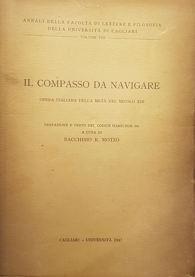
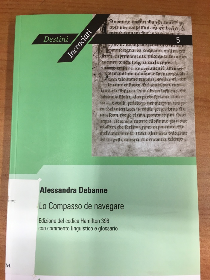
(Fig. 1) Motzo B. R., Il Compasso da navigare, Cagliari, University, 1947 (5).
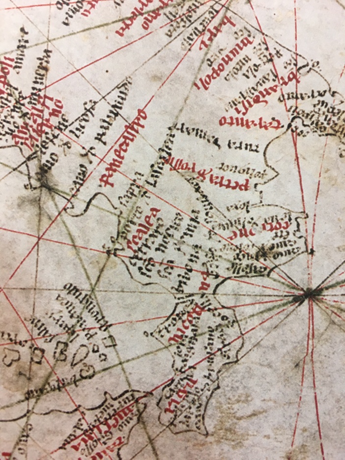
It is the oldest known portolano, relating to the whole Mediterranean that has been found to date. The medievalist scholar Bacchisio R. Motzo, in his work (Fig. 1), wrote in this regard: "The Compasso de navegare is an Italian work composed between 1250 and 1265 approximately, in two parts that complemented each other: the portolano, that is the written guide, to navigate in the Mediterranean, and the nautical chart of the Mediterranean itself". The Motzo, dates it back to the mid-thirteenth century on the basis of philological comparisons with other versions of the same text in the same period of the war of the Vespers and the Genoese participation in military operations (4), in fact, the text written in vulgar Latin, opens with the indication: "In nomine Domini Nostri Iesu Christi, amen. Incipit Liber Compassuum MCCLXXXXVI. De mense ianuari fuit inceptum opus istud". But this is the date of the copy; the primitive text of the Compasso, according to Motzo, would have been composed forty years earlier, exactly between 1250 and 1265. Compared to the original, the text presents a whole series of minor additions, expansions and remakes, as well as containing many errors due to the neglect of subsequent copyists and to having in addition the description of the coasts of the Black Sea. Recently, I was able to examine de visu the original medieval work annexed to the Codex Hamilton 396, (Fig. 2-3), preserved in the Municipal Library of Berlin and, here we report page 17r of the medieval text (which concerns our coasts), that we publish the two photoreproductions of the two original pages (Fig. 2-3) taken from the Hamilton Codex 396 and, photographed by my photographer friend Claudia Obrocki, with permission, images taken from the Handschriftenabteilung of the Staatsbibliothek Berlin (11). What does the original medieval text of pages 16r and 17r of Codex Hamilton 396 (Figs. 2-3) say?. Recently, the scholar Alessandra Debanne has revised and translated the text published by Motzo (Fig. 1), publishing it in one of her texts where she takes care of the translation of the medieval text of the Hamilton Codex 396 (Figs. 2-3-4), of the original written text in a Gothic tiny book of the late thirteenth century. The image of Fig. 4, illustrates the translation of page n. 17r of the 'Lo Compasso de navegare' (5): "Capo d(e) Mene(r)ba. Primariamente d(e) Menerba a Salerno xxx mil (lara) / p(er) greco verlo levante. De Salerno a lo capo de la Li/cosa l mil(lara) entre mecco dì e sirocco. De Licosa /20/ al capo de Palanua l mil(lara) p(er) sirocco ver lo leva(n)te. / De Palanuda a Panicastro xxv mil (lara) per greco v(er)lo levante. De Panicastro in Scalea xxv mil(lara) for / mecco di ver lo sirocco. Sopre Scalea à I ° island etc ... etc.." (4, 5, p. 17r) (Fig. 3).

(Fig. 2) Codex Hamilton 396 – page 16v (Lo Compasso de navegare), anonymous, January 1296 (original). Photo by Claudia Obrocki, 2017, with kind permission images taken from the Handschriftenabteilung of the Staatsbibliothek in Berlin (11).

(Fig. 3) Codex Hamilton 396, page 17 r of the Compasso de navegare, anonymous, January 1296 (original). Photo by Claudia Obrocki, 2017, with kind permission for the publication of images taken from the Handschriftenabteilung of the Staatsbibliothek in Berlin.

(Fig. 4)Â Lo Compasso de navegare, pag. 17 r translated and edited by Debanne Alessandra (5)
"Lo Compasso de navegare", cites 'Palanuda' (Palinuro), 'Panicastro' (Policastro) and Scalea and does not speak of Sapri. However, it should be noted that from the examination of the original medieval text, also for other coasts, the work limits itself to indicating the distances in miles from one important port to another, citing only the toponyms of the major ports and, leaving out the ports and minor seaports. We believe that the medieval work mentioned only the major seaports or free ports, those that in the 'Carta Pisana' (Fig. 2-3), are marked in red) and it is for this reason that it does not mention the port or seaport of Sapri which instead appears on the probable nautical chart attached to it, the Carta nautica called Carta Pisana (Fig. 5), where instead it appears with the toponym of 'Sapra'.

(Fig. 5) The nautical chart called 'Carta Pisana', of 1290 c. (7-8-9).
Antonelli (...), in this regard writes: "the oldest known portolano, called 'Compasso da navegare', was built in Tuscany and in the same period of the Carta Pisana" (XIII century), where among the ports and minor ports (marked in black), after 'Panecastro' (Policastro), includes the seaport of 'Sapra' (Fig. 5). In fact, looking at the 'Carta Pisana', nautical chart of the same period and perhaps annexed to the medieval text of the "Compasso de navegare", as claimed by the same discoverer Prof. Motzo: "... .. just that same map (or a similar one) was added to him.", you can see the major ports or free ports marked in red to distinguish them from the minor ones which was to be the port or seaport of 'Sapra' which also appears. The seaports marked in red in the 'Carta Pisana, are precisely those that the medieval anonymous text reports namely 'Salerno', Panecastro' and 'Scalea' (Fig. 6).
(Fig. 6) 'Carta Pisana' – detail of the Italian coast taken from the 'Carta Pisana'. The image is taken from the text by Jerry Brotton (9)
The toponym of 'Sapra' in the Carta detta Pisana, the oldest known (about 1290).
The fact that the toponym of Sapri is not mentioned in the medieval text does not mean that at the time Sapri did not exist but it means that the maritime port of Sapri was a minor port of call compared to the major ones such as Policastro which is mentioned. Moreover, as we have had the opportunity to ascertain and, as claimed by the same discoverer of the medieval manuscript text, Prof. Motzo, referring to the 'Carta Pisana' (where instead Sapri appears with the toponym of 'Sapra'): "... Just that same card (or a similar one) was added to him." The toponym of Sapri, is mentioned among the seaports of the 'Carta Pisana', of the same period of the medieval text. We can say with extreme certainty that Sapri, is mentioned in the 'Carta Pisana' with the toponym of 'Sapra'. The distinguished scholar of toponymy and ancient cartography Roberto Almagià , in one of his studies (7), pointed out that the toponym of Sapri, appears among the coastal towns of some medieval geographical and nautical maps. But, in the interesting prospectus of Almagià (7), we read that Sapri, or its ancient toponym, is not counted in the oldest known map, the 'Carta Pisana'. According to the prospectus of Almagià (7), on the 'Carta Pisana', there is only the toponym of 'Panecastro' (Policastro), as can be read in the prospectus reproduced here (Fig. 5). But this is not the case. We do not know why the illustrious scholar took this blunder, perhaps he had not examined de visu the authentic paper preserved in Paris. Sapri is counted among the ports or seaports of the Carta Pisana (8), with the toponym of Sapra together with Policastro (Panecastro), Palinuro (Cauo de Palinudo), Portum (perhaps Maratea) and Scalea (Fig. 5).

( Fig. 7) Prospectus taken from Almagià R., Toponomastica dell'Italia in alcune carte nautiche medioevali, stà in 'Monumenta Italia Cartographica', I.P.S., Firenze, 1929, Forni editore, Appendix I, p. 68.
Sapri in the nautical chart called Pisana, of 1290
Sapri, on the other hand, is counted with the ancient toponym of 'Sapra', in the nautical chart called 'Carta Pisana' (8), of which we have spoken in our study published here (Fig. 2), as can be clearly seen in the image that we publish here (Fig. 3), taken from the oldest known nautical chart 'Carta Pisana' (Fig. 2). At the height of the Tyrrhenian coasts of southern Italy and Cilento, you can see the toponyms of the seaports of 'Cauo Palanudo' (Capo Palinuro), Panecastro (Policastro), Sa- pra' or Saprà (?), Portum (at Maratea) and Scalea. The seaport of Sa- pra or Saprà (?) is black and is located right at the Gulf of Policastro. Policastro, which at the time (about 1290) was an important seaport and free port, is marked with the color red (Fig. 2). The discovery of the toponym Sapra, testifies and proves the documented existence of a landing or a port known by the name of Sapra in the thirteenth century and perhaps even earlier.
In the thirteenth century, Sapra or Portum
The absence of a Portum or the fief of Sapri, on the Angevin registers, which censused the population (1, 2, 3) which, at the time of the military operations of the war of the Vespers (1282-1302), had significantly decreased the number of inhabitants of the small coastal town of Sapri, does not prove that it did not exist at all. In fact, the Genoese presence in our area, the presence in our area of men from the Maritime Republic of Genoa, justifies the presence of the port of call of Sapri or 'Portum' on the first nautical charts or manuscript portolans that have come down to us and drawn up at that time, mainly by Genoese cartographers, paid by the Maritime Republic of Genoa who participated in military operations for the conquest of the Angevin Kingdom of Naples (3). We believe that Policastro or 'Panecastro' did not have a port but that its port was the natural bay of Sapri.
References:
(...) Attanasio F., "Sapri, incursioni nella notte dei tempi", stà in "I Corsivi", Dicembre 1987, Anno II, n. 12, pp. 9-10; the article was cited by Cesarino F., La Lucania del Barone Antonini, stà in "I Corsivi", n. 3, 1988; "I villaggi deserti del Cilento", rivista 'i Corsivi', Gen.- Feb., 1988, anno III, n. 1-2, Sapri, pp. 12-13; "La pittura locale a Villa Guariglia", magazine "I Corsivi", July 1987, year II, n. 7, Sapri, p. 29; "Notizie storiche su Castelruggero", magazine "I Corsivi", Sapri, dic. 1988, year II, n. 12, pp. 13-14; "Per un centro di storia cilentana", magazine "I Corsivi", Sapri, Nov. 1986, year I, n. 9, p. 23; "Per un' area di riequilibrio naturale", magazine "I Corsivi", August 1986, year I, n. 6, Sapri, p. 17; "Le fortificazioni primo-ottocentesche del litorale saprese attraverso alcuni disegni inediti", rivista 'Progetto', Salerno, Luglio 1994, anno V, n. 2., pp. 3-4; "Per una politica del recupero", Rivista 'Progetto', Salerno, May 1994, Year V, n. 1, pag. 11; "I villaggi deserti del Cilento", "Progetto", Salerno, April 1995, year VI, n. 2, p. 16; "Analysis on the historical-urban evolution of Sapri", signed by me, for the new General Town Plan (P.R.G.) of the Municipality of Sapri, drawn up by Prof. Francesco Forte, 1998; see also: 'The oldest maps of Italy annexed to the oldest known Greek codices', is on the web magazine 'Zedinfo', edited by Tonino Pitarresi, Palermo, ed. ZED, January 2018, available at: http://www.zedinfo.it/?p=9840
![]()
(Fig....) Attanasio Francesco, Sapri, incursioni nella notte dei tempi, stà nella rivista "I Corsivi", n. 12, Sapri, Dicembre 1987, pp. 9-10
(1) Natella P. Peduto P., 'Pixous – Policastro', excerpt from the I.G.M. MAGAZINE 'L'Universo', ed. I.G.M. Firenze, Anno LIII, N. 3, May-June 1973, p. 512 et seq. (Archivio Storico Attanasio)
(2) Volpe F., Il Cilento nel secolo XVII, ed. Ferraro, Napoli, 1981, p. 236.
(3) State Archives of Naples, Angevin Chancellery, Reg. 31°. Il documento pubblicato dal Volpe F., Il Cilento nel secolo XVII, ed. Ferraro, Napoli, 1981, p. 236.
(4) In 1947 Bachisio Raimondo MOTZO, published the text of a medieval portolan, the Codex Hamilton 396 (Ms. Hamilton 396), then kept at the Prussian State Library in Berlin (now the Berlin Municipal Library or Handschriftenabteilung of the Staatsbibliothek in Berlin), an anonymous text, dated 1296, entitled Compasso de Navegare. It is the oldest portolan relative to the whole Mediterranean that has been found to date. It is an Italian opera written in the vernacular, which cannot, however, be defined as Tuscan, Genoese or Venetian, since Catalan, Provençal, Arab and Byzantine words are frequent. One could speak, as Motzo said, of a "lingua franca" deriving from the fusion of different idioms and dialects, which was spoken by sailors from all over the Latin world to understand each other. Motzo's work was not limited to the publication of this manuscript, which was also very precious for the amount of data contained and for its originality, but was accompanied by a long introductory part in which the question of the origin and evolution of portolans and nautical charts was addressed, which, born at the same time, complemented each other during navigation. The Motzo also announced his intention to take care of the printing of three other portolani deriving from the Compasso and thus make a "Corpus" that would highlight the contribution made by Italy to the history of navigation. He referred, in particular, to the codices of Grazia Pauli (late fourteenth century), Carlo di Primerano (mid-fifteenth century) and Giovanni da Uzzano (mid-fifteenth century), some specimens of which are kept in the National Library and in the Riccardiana Library of Florence and in the University Library of Cagliari. Advancing age prevented Motzo from completing his project, which was interrupted with the transcription of the three manuscripts. Codex Hamilton 396 – The so-called Hamilton Codex is currently housed in the Prussian State Library in Berlin. Written on good parchment, measure cm. 21 x 14 and consists of 107 cards. The writing is a gothic book of the late thirteenth century. As far as the content is concerned, it is divided into three parts. The first describes the coasts from Cape St. Vincent in Portugal to Gibraltar; followed by the coasts of Catalonia, France, Italy, the Balkan peninsula up to Istanbul, Anatolia, Syria, Palestine and even North Africa up to Cape Spartel, and finally the Atlantic coasts of Morocco up to Saffì. The distances between the different locations calculated in miles are specified, always associated with the directions given according to the wind rose (or compass). There is also information on the seabed, currents, shoals, prevailing winds and docking and disembarkation procedures. The second part has a double object: on the one hand it collects a large number of crossings or paths through the open sea (pelei or pileggi) from one point to another generally distant from continental and island coasts, with mention of distances and directions; on the other hand it describes the circumnavigation of the great islands: the Balearic Islands, Sardinia, Corsica, Sicily, the Egadi, the Aeolian Islands, Malta, Crete, Milos, Cyprus. The third part, containing the description of the Black Sea coasts, is certainly a later addition being found after the explicit. The manuscript is of Italian origin. According to Motzo it was composed in Tuscany, more precisely in Pisa. In fact, the description of the Catalan, French and Provençal coasts, southern Italy and the Adriatic is rather summarized, compared to that of the Ligurian, Tuscan, Corsican and Sardinian coasts. This leads to the exclusion of Catalans, French, Provençals, but also southern Italians and Venetians. Two long signs of reference to the beginning of map 14, description of Porto Pisano, and at the beginning of map 15, description of Monte Argentario with Porto Ercole and Porto Santo Stefano, which are not reflected in the rest of the manuscript, reconnect it with Tuscany. In all probability it must have belonged to a Pisan navigator. The bottom of the language of the Compasso, although with infiltration of other languages and dialects, is substantially Tuscan, not cleaned of literary use, but as it was spoken by sailors accustomed to going from port to port. The Compass did not originally include the description of the Black Sea coasts. If the author had been a Genoese he would certainly not have omitted to describe it, since the Genoese interests in that sea are very strong.
(5) This is the aforementioned portolano published by B. R. MOTZO under the title: Il Compasso da Navigare, opera italiana detta metà del secolo XIII, stà in Annali della Facoltà di Lettere e Filosofia dell'Università di Cagliari, Cagliari, voI. VIII, 1947, p. 166; the page of the original text of 1296, here reported and translated by Debanne A., Lo Compasso de navegare, Edition of the Codex Hamilton 396, Publisher Peter Lang Gmbh, Internationaler Verlag Der W, 2011, pag. 48. the page of the original text of 1296, reported here and translated by Debanne is page no. 17 r (Fig. 4).
(6) De La Ronciere A. M. , M. Mollat Du Jourdin, I portolani, carte nautiche dal XIII al XVII secolo, ed. Bramante, Milano, 1992, pag. 193. The 'Compasso de navegare' (4:5) is also mentioned by the distinguished French scholars Monique De La Ronciere and Michel Mollat du Jourdin who, in their book for the types of Bramante, (6), referring to the navigator of the thirteenth century, write in this regard:Â "He has, among other things, a book of the sea, a kind of nautical manual dating back to the periples of Antiquity. The oldest currently existing, the Compasso da navigare, is kept at the Berlin Municipal Library (Ms Hamilton 397) for the sailor of the time it was what the "portolano" was for the navigator of our days. It bears the date of January 1296 and would be from the same period as the 'Pisan Charter'. According to Professor Motzo, that same card (or a similar one) was added to him. Despite being complementary, the manual and paper will have different fortunes; currently the ancient manual is much rarer than the nautical chart of which we count, for the fourteenth and fifteenth centuries, a hundred specimens.
(7) (Fig. 5) Almagià R., Toponomastica dell'Italia in alcune carte nautiche medioevali, stà in Monumenta Italia Cartographica, I.P.S., Firenze, 1929, Forni editore, Appendix I, I – Coste liguri e tirreniche della penisola, p. 68.
(8) ibid., this map reproduced in the text of Almagià R., op. cit. cit., tav. III, p. 3, we believe it was reported 'Sapra' and not 'Saprì'. We publish the one taken from the text of De La Ronciere A. M. , M. Mollat Du Jourdin, I portolani, carte nautiche dal XIII al XVII secolo, ed. Bramante, Milano, 1992, Tav. 1.
(9) (Figs. 5 and 6) from Brotton J., The Great Maps, ed. Gribaudo, 2014, pp. 52, 53.
Afegeix-hi un comentari: